
파일:Hilo after Tsunami 1960.jpg
미리 보기 크기: 756 × 600 픽셀 다른 해상도: 303 × 240 픽셀 | 605 × 480 픽셀 | 838 × 665 픽셀
원본 파일 (838 × 665 픽셀, 파일 크기: 185 KB, MIME 종류: image/jpeg)
파일 설명
| 설명 |
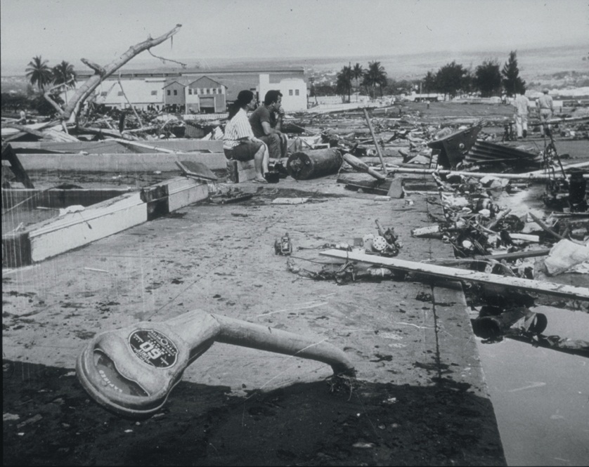
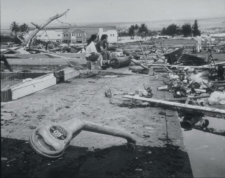
English: Tsunami Generated by Earthquake of May 22, 1960, Coast of Chile
The Waiakea area of Hilo, Hawaii, 10,000 km from the generating area. Parking meters were bent by the force of the debris-filled waves. Note the scattered debris and the gutted foundation. This tsunami, generated by the earthquake off the coast of central Chile, affected the entire Pacific Basin. One of the most seriously affected areas was Hilo, Hawaii, where 61 deaths and $24 million in damage occurred. In the area of maximum destruction, only buildings of reinforced concrete or structural steel, and a few others sheltered by these buildings, remained standing -- and even these were generally gutted. Frame buildings either were crushed or floated early to the limits of flooding. Photo credit: U.S. Navy |
| 날짜 | |
| 출처 | http://www.ngdc.noaa.gov/nndc/struts/results?EQ_0=4227&t=101634&s=80&d=80 |
| 저자 | US Navy |
라이선스
 | ||
| 이 저작물은 모든 저작인접권을 포함한 저작권법하의 규제로부터 자유로운 것으로 확인되었습니다. | ||
파일 역사
날짜/시간 링크를 클릭하면 해당 시간의 파일을 볼 수 있습니다.
| 날짜/시간 | 섬네일 | 크기 | 사용자 | 설명 | |
|---|---|---|---|---|---|
| 현재 | 2010년 3월 22일 (월) 06:06 | | 838 × 665 (185 KB) | Q-ß | {{Information |Description={{en|1=Tsunami Generated by Earthquake of May 22, 1960, Coast of Chile The Waiakea area of Hilo, Hawaii, 10,000 km from the generating area. Parking meters were bent by the force of the debris-filled waves. Note the scattered de |
이 파일을 사용하는 문서
다음 문서 1개가 이 파일을 사용하고 있습니다:
이 파일을 사용하고 있는 모든 위키의 문서 목록
다음 위키에서 이 파일을 사용하고 있습니다:
- ckb.wikipedia.org에서 이 파일을 사용하고 있는 문서 목록
- de.wikipedia.org에서 이 파일을 사용하고 있는 문서 목록
- el.wikipedia.org에서 이 파일을 사용하고 있는 문서 목록
- en.wikipedia.org에서 이 파일을 사용하고 있는 문서 목록
- es.wikipedia.org에서 이 파일을 사용하고 있는 문서 목록
- fa.wikipedia.org에서 이 파일을 사용하고 있는 문서 목록
- fy.wikipedia.org에서 이 파일을 사용하고 있는 문서 목록
- id.wikipedia.org에서 이 파일을 사용하고 있는 문서 목록
- ja.wikipedia.org에서 이 파일을 사용하고 있는 문서 목록
- nl.wikipedia.org에서 이 파일을 사용하고 있는 문서 목록
- pl.wikipedia.org에서 이 파일을 사용하고 있는 문서 목록
- pt.wikipedia.org에서 이 파일을 사용하고 있는 문서 목록