
파일:Gillespie and Cambria in Portage.jpg

미리 보기 크기: 800 × 532 픽셀 다른 해상도: 320 × 213 픽셀 | 640 × 426 픽셀 | 1,024 × 681 픽셀 | 1,280 × 851 픽셀 | 2,560 × 1,702 픽셀 | 6,016 × 4,000 픽셀
원본 파일 (6,016 × 4,000 픽셀, 파일 크기: 6.34 MB, MIME 종류: image/jpeg)
|
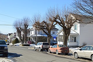
This is an image of a place or building that is listed on the National Register of Historic Places in the United States of America. Its reference number is 95000890. |
| 카메라 위치 | | 이 지역의 다른 사진을 보기: OpenStreetMap |
|---|
| 설명 |
English: Houses on the northern side of Gillespie Street at the Cambria Street intersection in Portage, Pennsylvania, United States. This neighborhood is part of the Portage Historic District, a historic district that is listed on the National Register of Historic Places. |
||
| 날짜 | 촬영 날짜: 2015년 2월 28일 | ||
| 출처 | 자작 | ||
| 저자 | Nyttend | ||
| 저작권 (이 파일을 인용하기) |
|
파일 역사
날짜/시간 링크를 클릭하면 해당 시간의 파일을 볼 수 있습니다.
| 날짜/시간 | 섬네일 | 크기 | 사용자 | 설명 | |
|---|---|---|---|---|---|
| 현재 | 2015년 3월 7일 (토) 14:17 | | 6,016 × 4,000 (6.34 MB) | Nyttend | {{NRHP|95000890}} {{Location|40|23|12|N|78|40|29|W}} {{Information |Description={{en|Houses on the northern side of Gillespie Street at the Cambria Street intersection in {{w|Portage, Pennsylvania|Portage}}, {{w|Pennsylvania}}, {{w|United States}}. Th... |
이 파일을 사용하는 문서
다음 문서 1개가 이 파일을 사용하고 있습니다:
이 파일을 사용하고 있는 모든 위키의 문서 목록
다음 위키에서 이 파일을 사용하고 있습니다:
- ar.wikipedia.org에서 이 파일을 사용하고 있는 문서 목록
- ceb.wikipedia.org에서 이 파일을 사용하고 있는 문서 목록
- ce.wikipedia.org에서 이 파일을 사용하고 있는 문서 목록
- cy.wikipedia.org에서 이 파일을 사용하고 있는 문서 목록
- en.wikipedia.org에서 이 파일을 사용하고 있는 문서 목록
- es.wikipedia.org에서 이 파일을 사용하고 있는 문서 목록
- eu.wikipedia.org에서 이 파일을 사용하고 있는 문서 목록
- fr.wikipedia.org에서 이 파일을 사용하고 있는 문서 목록
- ht.wikipedia.org에서 이 파일을 사용하고 있는 문서 목록
- it.wikipedia.org에서 이 파일을 사용하고 있는 문서 목록
- lld.wikipedia.org에서 이 파일을 사용하고 있는 문서 목록
- pl.wikipedia.org에서 이 파일을 사용하고 있는 문서 목록
- pt.wikipedia.org에서 이 파일을 사용하고 있는 문서 목록
- sr.wikipedia.org에서 이 파일을 사용하고 있는 문서 목록
- szl.wikipedia.org에서 이 파일을 사용하고 있는 문서 목록
- tl.wikipedia.org에서 이 파일을 사용하고 있는 문서 목록
- tt.wikipedia.org에서 이 파일을 사용하고 있는 문서 목록
- uk.wikipedia.org에서 이 파일을 사용하고 있는 문서 목록
- ur.wikipedia.org에서 이 파일을 사용하고 있는 문서 목록
- uz.wikipedia.org에서 이 파일을 사용하고 있는 문서 목록
- vi.wikipedia.org에서 이 파일을 사용하고 있는 문서 목록
- www.wikidata.org에서 이 파일을 사용하고 있는 문서 목록
- zh-min-nan.wikipedia.org에서 이 파일을 사용하고 있는 문서 목록