
파일:French and Indian War map.png
미리 보기 크기: 561 × 599 픽셀 다른 해상도: 225 × 240 픽셀 | 449 × 480 픽셀 | 719 × 768 픽셀 | 958 × 1,024 픽셀 | 2,128 × 2,274 픽셀
원본 파일 (2,128 × 2,274 픽셀, 파일 크기: 858 KB, MIME 종류: image/png)
파일 설명
| 설명 |
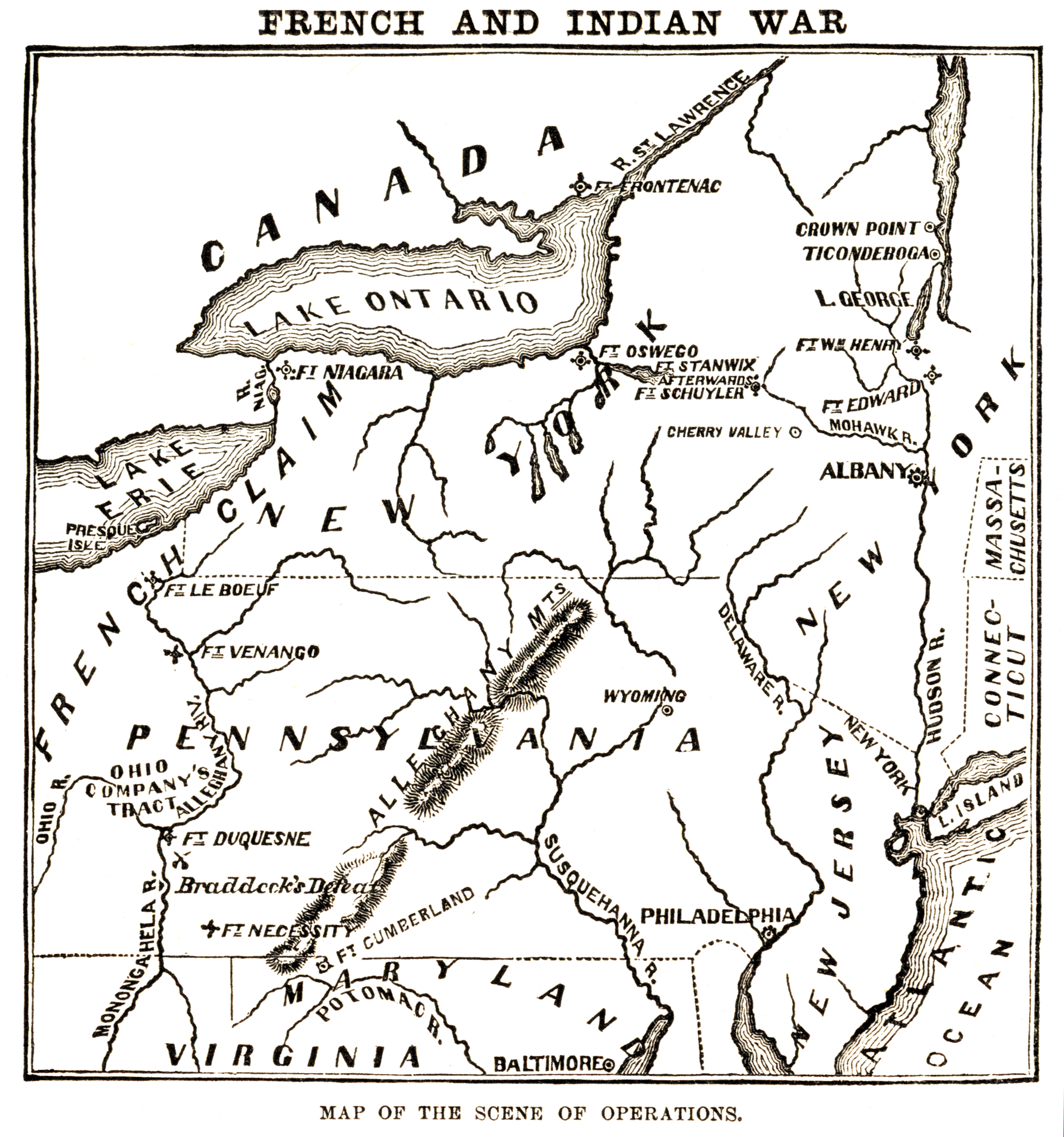
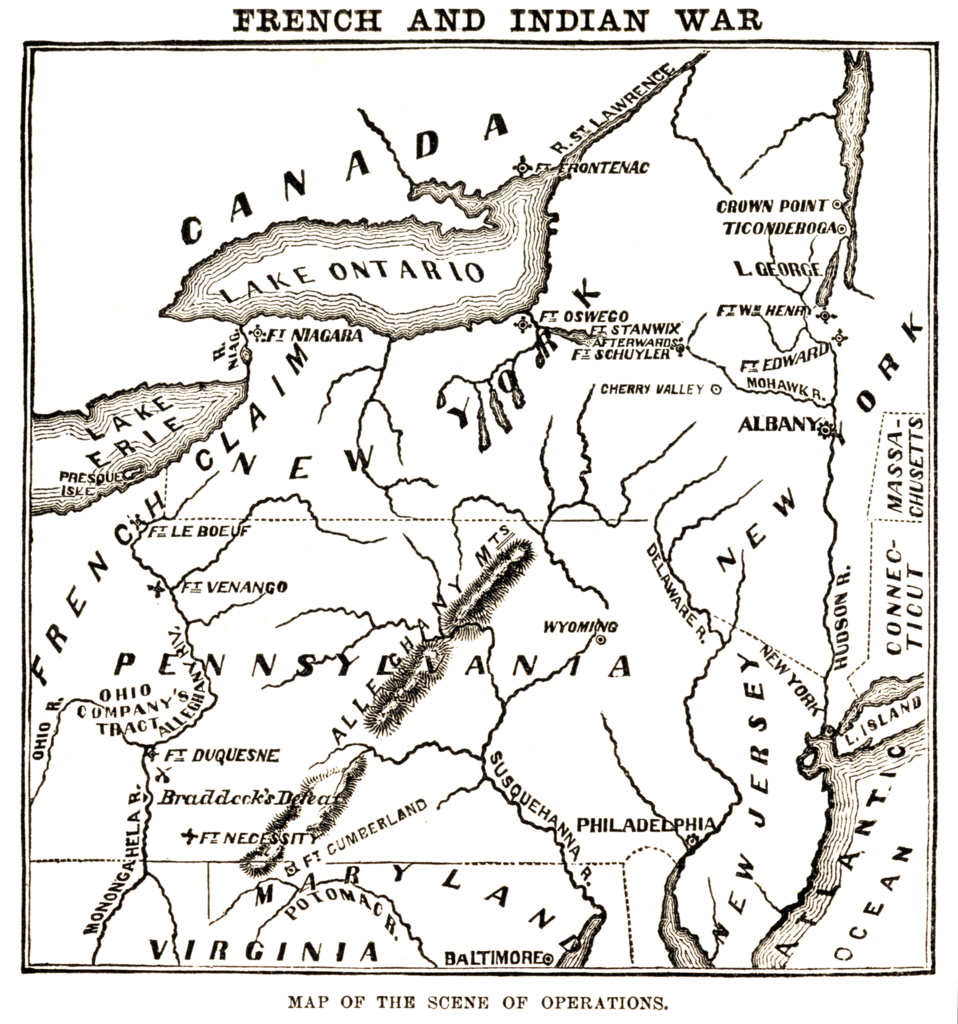
English: Map of the "scene of operations" of the en:French and Indian War. |
| 출처 | Harper's Encyclopedia of United States History, Harper & Brothers, 1905. |
| 저자 | Harper & Brothers |
라이선스
|
이 작품은 미국, 그리고 저작권 보호 기간이 저작자 사후 70년, 또는 그 이하인 모든 국가에서 퍼블릭 도메인입니다.
| |
| 이 저작물은 모든 저작인접권을 포함한 저작권법하의 규제로부터 자유로운 것으로 확인되었습니다. | |
기존 올리기 기록
The original description page was here. All following user names refer to en.wikipedia.
- 2006-05-02 01:31 Nonenmac 2128×2274×8 (878312 bytes) Map of the "scene of operations" of the [[French and Indian War]]. {{Harper's Encyclopedia of US History}}
파일 역사
날짜/시간 링크를 클릭하면 해당 시간의 파일을 볼 수 있습니다.
| 날짜/시간 | 섬네일 | 크기 | 사용자 | 설명 | |
|---|---|---|---|---|---|
| 현재 | 2008년 1월 6일 (일) 06:31 | | 2,128 × 2,274 (858 KB) | Tomia | full resolution from en: |
| 2007년 5월 12일 (토) 16:45 |  | 561 × 599 (318 KB) | איתן6 | {{Information |Description= |Source=ויקיפדיה |Date= |Author= }} |
이 파일을 사용하는 문서
이 파일을 사용하는 문서가 없습니다.
이 파일을 사용하고 있는 모든 위키의 문서 목록
다음 위키에서 이 파일을 사용하고 있습니다:
- ca.wikipedia.org에서 이 파일을 사용하고 있는 문서 목록
- en.wikipedia.org에서 이 파일을 사용하고 있는 문서 목록
- es.wikipedia.org에서 이 파일을 사용하고 있는 문서 목록
- it.wikipedia.org에서 이 파일을 사용하고 있는 문서 목록
- ja.wikipedia.org에서 이 파일을 사용하고 있는 문서 목록
- nn.wikipedia.org에서 이 파일을 사용하고 있는 문서 목록
- no.wikipedia.org에서 이 파일을 사용하고 있는 문서 목록
- pt.wikipedia.org에서 이 파일을 사용하고 있는 문서 목록
- ru.wikipedia.org에서 이 파일을 사용하고 있는 문서 목록
- sh.wikipedia.org에서 이 파일을 사용하고 있는 문서 목록
- sv.wikipedia.org에서 이 파일을 사용하고 있는 문서 목록
- uk.wikipedia.org에서 이 파일을 사용하고 있는 문서 목록
- www.wikidata.org에서 이 파일을 사용하고 있는 문서 목록
- zh.wikipedia.org에서 이 파일을 사용하고 있는 문서 목록