
파일:Emancipation Proclamation.PNG
미리 보기 크기: 800 × 520 픽셀 다른 해상도: 320 × 208 픽셀 | 640 × 416 픽셀 | 1,024 × 665 픽셀 | 1,513 × 983 픽셀
원본 파일 (1,513 × 983 픽셀, 파일 크기: 54 KB, MIME 종류: image/png)

|
이 그림 파일은 벡터 SVG 형식으로 다시 만들어야 합니다. SVG의 장점에 대해서는 여기(영어)를 참고해 주십시오. 만약 이 그림의 SVG 버전이 이미 존재한다면 이 틀을 {{vector version available|새 파일 이름.svg}}으로 대체해 주십시오.
|
파일 설명
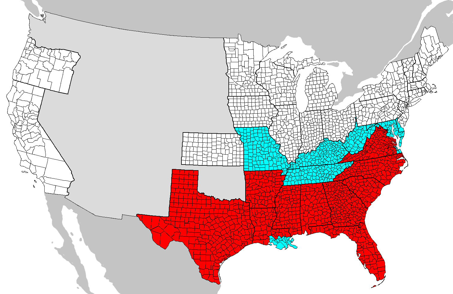
| 설명 | Map of counties covered (red) and not covered (blue) by the Emancipation Proclamation. Map needs updating as these county boundaries reflect modern boundaries and not those during 1862, with some counties displayed on this map not existing at the time. |
| 날짜 | (UTC) |
| 출처 | |
| 저자 |
|
| 이 그림은 수정된 그림으로, 원래 그림에서 디지털 변환이 이루어진 그림입니다. 수정 사항 : Added colors. 원래의 그림 : Map of USA with county outlines.png:
|

|
GNU 자유 문서 사용 허가서 1.2판 또는 자유 소프트웨어 재단에서 발행한 이후 판의 규정에 따라 본 문서를 복제하거나 개작 및 배포할 수 있습니다. 본 문서에는 변경 불가 부분이 없으며, 앞 표지 구절과 뒷 표지 구절도 없습니다. 본 사용 허가서의 전체 내용은 GNU 자유 문서 사용 허가서 부분에 포함되어 있습니다. |
| 이 파일은 크리에이티브 커먼즈 저작자표시-동일조건변경허락 3.0 Unported 라이선스로 배포됩니다. | ||
| ||
| 이 라이선스 틀은 GFDL 라이선스 변경의 일부로 이 파일에 추가되었습니다. |
== 기존 올리기 기록 == blue This image is a derivative work of the following images:
- Image:Map_of_USA_with_county_outlines.png licensed with GFDL
- 2008-01-23T04:41:16Z Speight 1513x983 (100713 Bytes) Fix San Francisco Bay and Puget Sound
- 2006-11-23T22:53:51Z Ibagli 1513x983 (169345 Bytes) more fixes
- 2006-11-23T22:53:05Z Ibagli 1513x983 (169416 Bytes) Reverted to earlier revision
- 2006-11-23T22:52:41Z Ibagli 1513x983 (184378 Bytes) more fixes
- 2006-11-23T02:16:28Z Ibagli 1513x983 (169416 Bytes) fix lake St. Clair
- 2005-08-28T20:57:13Z Huhsunqu 1513x983 (169340 Bytes) *{{es}} Mapa de los [[Estados Unidos de América]] mostrando los los límites de estados miembros y sus condados. Versión a colores de la adaptación hecha por [[en:User:Wapcaplet|Wapcaplet]] del mapa de dominio público del
Uploaded with derivativeFX
파일 역사
날짜/시간 링크를 클릭하면 해당 시간의 파일을 볼 수 있습니다.
| 날짜/시간 | 섬네일 | 크기 | 사용자 | 설명 | |
|---|---|---|---|---|---|
| 현재 | 2020년 6월 14일 (일) 09:46 | | 1,513 × 983 (54 KB) | JasonAQuest | remove non-states |
| 2008년 6월 1일 (일) 13:31 |  | 1,513 × 983 (171 KB) | SFGiants | {{Information |Description=== Summary == Map of counties covered and not covered by the Emancipation Proclamation. |Source=*Image:Map_of_USA_with_county_outlines.png |Date=2008-06-01 04:29 (UTC) |Author=*derivative w |
이 파일을 사용하는 문서
다음 문서 1개가 이 파일을 사용하고 있습니다:
이 파일을 사용하고 있는 모든 위키의 문서 목록
다음 위키에서 이 파일을 사용하고 있습니다:
- cs.wikipedia.org에서 이 파일을 사용하고 있는 문서 목록
- da.wikipedia.org에서 이 파일을 사용하고 있는 문서 목록
- el.wikipedia.org에서 이 파일을 사용하고 있는 문서 목록
- en.wikipedia.org에서 이 파일을 사용하고 있는 문서 목록
- en.wikibooks.org에서 이 파일을 사용하고 있는 문서 목록
- fi.wikipedia.org에서 이 파일을 사용하고 있는 문서 목록
- fr.wikipedia.org에서 이 파일을 사용하고 있는 문서 목록
- he.wikipedia.org에서 이 파일을 사용하고 있는 문서 목록
- it.wikipedia.org에서 이 파일을 사용하고 있는 문서 목록
- ja.wikipedia.org에서 이 파일을 사용하고 있는 문서 목록
- simple.wikipedia.org에서 이 파일을 사용하고 있는 문서 목록
- sr.wikipedia.org에서 이 파일을 사용하고 있는 문서 목록
- zh.wikipedia.org에서 이 파일을 사용하고 있는 문서 목록