
파일:Egypt Sudan claims.svg

SVG 파일의 PNG 형식의 미리보기 크기: 400 × 600 픽셀. 다른 해상도: 160 × 240 픽셀 | 320 × 480 픽셀 | 512 × 768 픽셀 | 682 × 1,024 픽셀 | 1,365 × 2,048 픽셀
원본 파일 (SVG 파일, 실제 크기 512 × 768 픽셀, 파일 크기: 461 KB)
파일 설명
| 설명 |
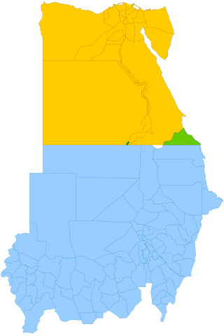
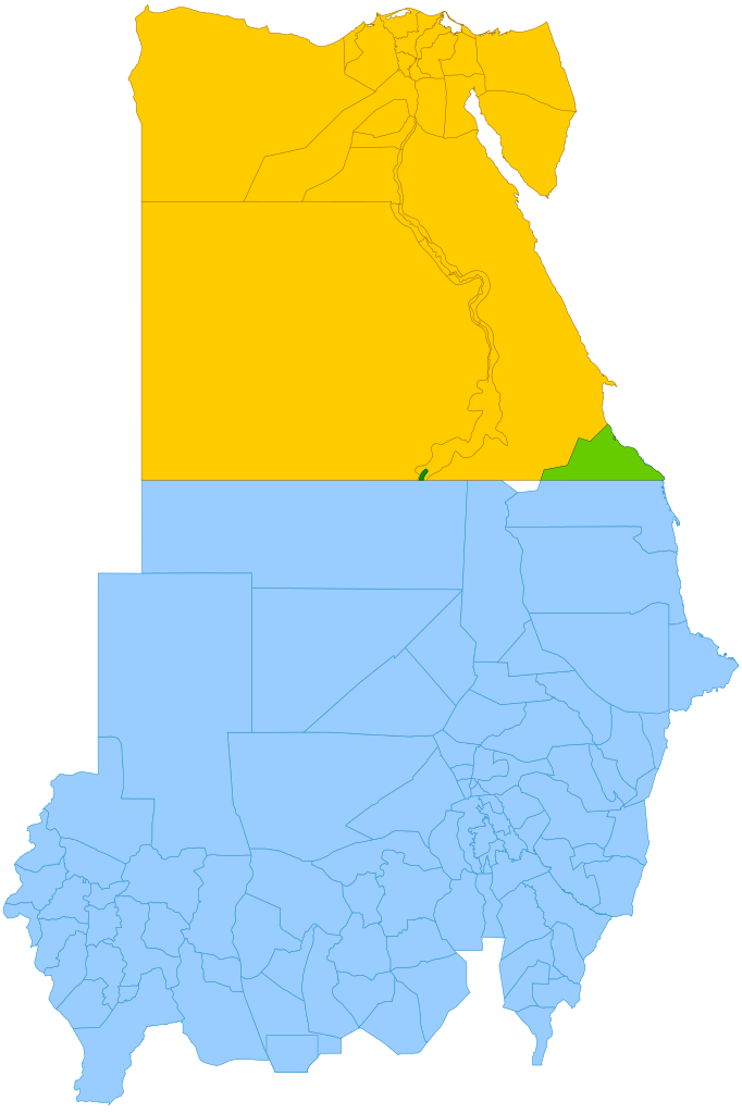
English: Simplified map showing Egypt's claim (yellow and green), Sudan's claim (blue and green), the Hala'ib Triangle (light green), Wadi Halfa Salient (dark green) and Bir Tawil (white). |
| 날짜 | (UTC) |
| 출처 |
이 파일은 다음에 의해 파생됨: |
| 저자 | |
| SVG 발전 |

라이선스
이 파일은 크리에이티브 커먼즈 저작자표시-동일조건변경허락 3.0 Unported 라이선스로 배포됩니다.
- 이용자는 다음의 권리를 갖습니다:
- 공유 및 이용 – 저작물의 복제, 배포, 전시, 공연 및 공중송신
- 재창작 – 저작물의 개작, 수정, 2차적저작물 창작
- 다음과 같은 조건을 따라야 합니다:
- 저작자표시 – 적절한 저작자 표시를 제공하고, 라이센스에 대한 링크를 제공하고, 변경사항이 있는지를 표시해야 합니다. 당신은 합리적인 방식으로 표시할 수 있지만, 어떤 방식으로든 사용권 허가자가 당신 또는 당신의 사용을 지지하는 방식으로 표시할 수 없습니다.
- 동일조건변경허락 – 만약 당신이 이 저작물을 리믹스 또는 변형하거나 이 저작물을 기반으로 제작하는 경우, 당신은 당신의 기여물을 원저작물과 동일하거나 호환 가능한 라이선스에 따라 배포하여야 합니다.
기존 올리기 기록
This image is a derivative work of the following images:
- File:Political_Regions_of_Sudan,_July_2010.svg licensed with Cc-zero
- File:Egypt_location_map.svg licensed with Cc-by-sa-3.0, GFDL
- 2011-04-17T16:03:10Z NordNordWest 1055x973 (359140 Bytes) upd
- 2010-03-07T17:03:18Z NordNordWest 1055x973 (566369 Bytes) resize
- 2009-09-03T10:48:31Z NordNordWest 1055x956 (565065 Bytes)
- 2009-05-23T19:10:12Z NordNordWest 1056x959 (570357 Bytes) corr
- 2008-08-10T11:12:09Z NordNordWest 1056x957 (503154 Bytes) {{Information |Description= {{de|Positionskarte von [[:de:Ägypten|Ägypten]]}} Quadratische Plattkarte, N-S-Streckung 110 %. Geographische Begrenzung der Karte: * N: 32.1° N * S: 21.3° N * W: 24.2° O * O: 37.3° O {{en|Lo
Uploaded with derivativeFX
파일 역사
날짜/시간 링크를 클릭하면 해당 시간의 파일을 볼 수 있습니다.
| 날짜/시간 | 섬네일 | 크기 | 사용자 | 설명 | |
|---|---|---|---|---|---|
| 현재 | 2021년 10월 13일 (수) 20:15 | | 512 × 768 (461 KB) | Cmglee | Shade Wadi Halfa Salient as per http://commons.wikimedia.org/wiki/File_talk:Egypt_Sudan_claims.svg#Wadi_Halfa_Salient |
| 2019년 2월 16일 (토) 21:58 |  | 512 × 768 (461 KB) | AntiCompositeNumber | Avoid messing with file structure so much when <!-- --> will work | |
| 2019년 2월 16일 (토) 21:51 |  | 512 × 768 (465 KB) | AntiCompositeNumber | Remove striping that makes image harder to see per request at e n:Wikipedia:Graphics_Lab/Map_workshop | |
| 2018년 6월 22일 (금) 02:47 |  | 512 × 768 (461 KB) | Cmglee | Add white background as per File_talk:Egypt_Sudan_claims.svg#Bir_Tawil_area | |
| 2015년 11월 9일 (월) 02:44 |  | 512 × 768 (460 KB) | McGeddon | Remove unnecessary captions, image is colour-coded. | |
| 2013년 1월 12일 (토) 06:28 |  | 512 × 768 (461 KB) | Cmglee | Update colours and label alignment. | |
| 2013년 1월 12일 (토) 06:19 |  | 512 × 768 (461 KB) | Cmglee | == {{int:filedesc}} == {{Information |Description={{en|Map showing political regions of Sudan as of July 2006.}} {{legend|#8cc63f|Darfur}} {{legend|#fb6282|Nuba Mountains and Blue Nile}} {{legend|#f7931d|North Sudan}} {{legend|#800080|Eastern Front, ar... |
이 파일을 사용하는 문서
다음 문서 1개가 이 파일을 사용하고 있습니다:
이 파일을 사용하고 있는 모든 위키의 문서 목록
다음 위키에서 이 파일을 사용하고 있습니다:
- ar.wikipedia.org에서 이 파일을 사용하고 있는 문서 목록
- arz.wikipedia.org에서 이 파일을 사용하고 있는 문서 목록
- az.wikipedia.org에서 이 파일을 사용하고 있는 문서 목록
- be.wikipedia.org에서 이 파일을 사용하고 있는 문서 목록
- cs.wikipedia.org에서 이 파일을 사용하고 있는 문서 목록
- da.wikipedia.org에서 이 파일을 사용하고 있는 문서 목록
- de.wikipedia.org에서 이 파일을 사용하고 있는 문서 목록
- de.wikivoyage.org에서 이 파일을 사용하고 있는 문서 목록
- el.wikipedia.org에서 이 파일을 사용하고 있는 문서 목록
- en.wikipedia.org에서 이 파일을 사용하고 있는 문서 목록
- en.wikivoyage.org에서 이 파일을 사용하고 있는 문서 목록
- eo.wikipedia.org에서 이 파일을 사용하고 있는 문서 목록
- es.wikipedia.org에서 이 파일을 사용하고 있는 문서 목록
- fi.wikipedia.org에서 이 파일을 사용하고 있는 문서 목록
- fr.wikipedia.org에서 이 파일을 사용하고 있는 문서 목록
- gl.wikipedia.org에서 이 파일을 사용하고 있는 문서 목록
- id.wikipedia.org에서 이 파일을 사용하고 있는 문서 목록
- it.wikipedia.org에서 이 파일을 사용하고 있는 문서 목록
- ja.wikipedia.org에서 이 파일을 사용하고 있는 문서 목록
- ja.wikivoyage.org에서 이 파일을 사용하고 있는 문서 목록
- ms.wikipedia.org에서 이 파일을 사용하고 있는 문서 목록
- nl.wikipedia.org에서 이 파일을 사용하고 있는 문서 목록
- no.wikipedia.org에서 이 파일을 사용하고 있는 문서 목록
- pt.wikipedia.org에서 이 파일을 사용하고 있는 문서 목록
- ro.wikipedia.org에서 이 파일을 사용하고 있는 문서 목록
- so.wikipedia.org에서 이 파일을 사용하고 있는 문서 목록
- sr.wikipedia.org에서 이 파일을 사용하고 있는 문서 목록
- uk.wikipedia.org에서 이 파일을 사용하고 있는 문서 목록
- vi.wikipedia.org에서 이 파일을 사용하고 있는 문서 목록
- www.wikidata.org에서 이 파일을 사용하고 있는 문서 목록
- zh.wikipedia.org에서 이 파일을 사용하고 있는 문서 목록
이 파일의 더 많은 사용 내역을 봅니다.