
파일:Democratic Party presidential primaries results by county, 2016.svg

SVG 파일의 PNG 형식의 미리보기 크기: 800 × 507 픽셀. 다른 해상도: 320 × 203 픽셀 | 640 × 406 픽셀 | 1,024 × 649 픽셀 | 1,280 × 811 픽셀 | 2,560 × 1,623 픽셀 | 989 × 627 픽셀
원본 파일 (SVG 파일, 실제 크기 989 × 627 픽셀, 파일 크기: 1.3 MB)
파일 설명
| 설명 |
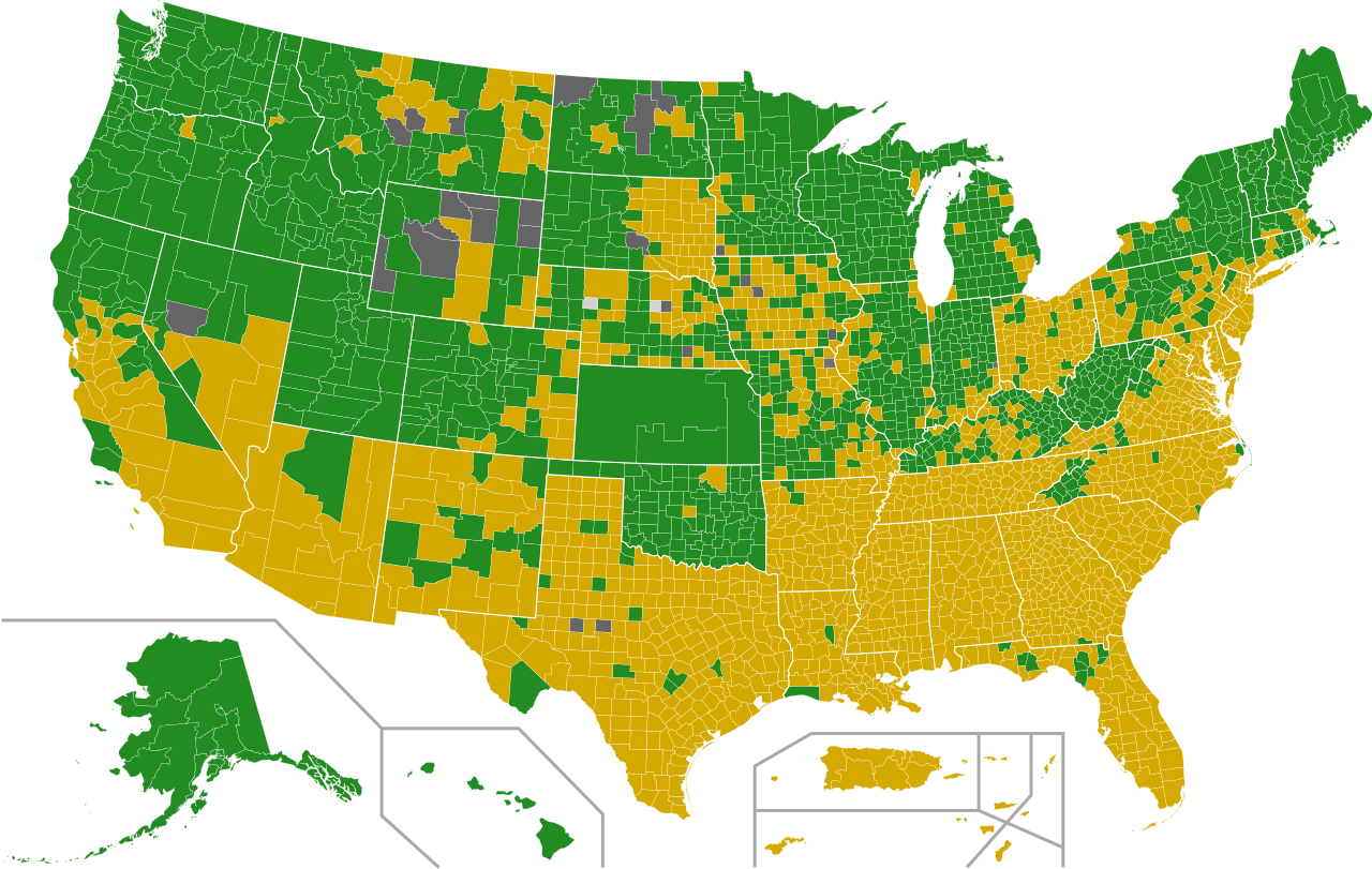
English: Map of the Democratic Party (United States) presidential primaries, 2016 by county.
Hillary Clinton Bernie Sanders Tie No results |
||||||||||||||
| 날짜 | |||||||||||||||
| 출처 |
이 파일은 다음에 의해 파생됨: USA Counties.svg |
||||||||||||||
| 저자 | Ali Zifan, Prcc27, AHC300, Jc86035, Abjiklam, Magog the Ogre, Sleepingstar, Jvikings1, JCRules, Kingofthedead, Tld1060 와 Gage | ||||||||||||||
| 저작권 (이 파일을 인용하기) |
나는 아래 작품의 저작권자로서, 이 저작물을 다음과 같은 라이선스로 배포합니다:
|
||||||||||||||
| 다른 버전 |
[]
|
||||||||||||||
| SVG 발전 | 이 SVG 파일의 소스 코드를 1001가지의 실수입니다. 이 W3C-무효 벡터 그림은 Other tools(으)로 제작되었습니다. |
.svg)
.svg)


.svg)
.svg)
_by_election_methods,_2016_(Republican_Party).svg)
.svg)


.svg)
.svg)
.svg)


.svg)
.svg)
_by_election_methods,_2016_(Democratic_Party).svg)


| 주석 | 이 이미지에는 주석이 있습니다: 공용에서 주석을 보기 |
파일 역사
날짜/시간 링크를 클릭하면 해당 시간의 파일을 볼 수 있습니다.
| 날짜/시간 | 섬네일 | 크기 | 사용자 | 설명 | |
|---|---|---|---|---|---|
| 현재 | 2016년 12월 12일 (월) 06:51 | | 989 × 627 (1.3 MB) | WikiBunny2K1 | Corrected some Nebraska counties |
| 2016년 12월 12일 (월) 06:44 |  | 989 × 627 (1.3 MB) | WikiBunny2K1 | Removed unnecessary data | |
| 2016년 7월 7일 (목) 08:02 |  | 989 × 627 (1.35 MB) | Tdl1060 | Sonoma County, CA for Sanders per http://vote.sos.ca.gov/returns/maps/president/party/democratic/ | |
| 2016년 7월 2일 (토) 10:40 |  | 989 × 627 (1.35 MB) | Tdl1060 | Updated El Dorado County, CA. Won by Sanders per http://vote.sos.ca.gov/returns/maps/president/party/democratic/ | |
| 2016년 6월 24일 (금) 09:01 |  | 989 × 627 (1.35 MB) | Tdl1060 | Updated CA per http://vote.sos.ca.gov/returns/maps/president/party/democratic/ | |
| 2016년 6월 15일 (수) 10:09 |  | 989 × 627 (1.62 MB) | Kingofthedead | DC for Hillary. Map's done! | |
| 2016년 6월 15일 (수) 10:09 |  | 989 × 627 (1.33 MB) | Tdl1060 | DC for Hillary Clinton | |
| 2016년 6월 14일 (화) 03:51 |  | 989 × 627 (1.35 MB) | Tdl1060 | Updated CA counties per http://vote.sos.ca.gov/returns/maps/president/party/democratic/ | |
| 2016년 6월 9일 (목) 08:48 |  | 989 × 627 (1.62 MB) | Kingofthedead | fix | |
| 2016년 6월 9일 (목) 01:18 |  | 990 × 627 (1.75 MB) | Spesh531 | with north dakota |
이 파일을 사용하는 문서
다음 문서 1개가 이 파일을 사용하고 있습니다:
이 파일을 사용하고 있는 모든 위키의 문서 목록
다음 위키에서 이 파일을 사용하고 있습니다:
- cs.wikipedia.org에서 이 파일을 사용하고 있는 문서 목록
- da.wikipedia.org에서 이 파일을 사용하고 있는 문서 목록
- de.wikipedia.org에서 이 파일을 사용하고 있는 문서 목록
- en.wikipedia.org에서 이 파일을 사용하고 있는 문서 목록
- es.wikipedia.org에서 이 파일을 사용하고 있는 문서 목록
- fr.wikipedia.org에서 이 파일을 사용하고 있는 문서 목록
- nl.wikipedia.org에서 이 파일을 사용하고 있는 문서 목록
- no.wikipedia.org에서 이 파일을 사용하고 있는 문서 목록
- pl.wikipedia.org에서 이 파일을 사용하고 있는 문서 목록
- pt.wikipedia.org에서 이 파일을 사용하고 있는 문서 목록
- simple.wikipedia.org에서 이 파일을 사용하고 있는 문서 목록