
파일:Cotedazur.png
미리 보기 크기: 800 × 498 픽셀 다른 해상도: 320 × 199 픽셀 | 640 × 398 픽셀 | 826 × 514 픽셀
원본 파일 (826 × 514 픽셀, 파일 크기: 453 KB, MIME 종류: image/png)
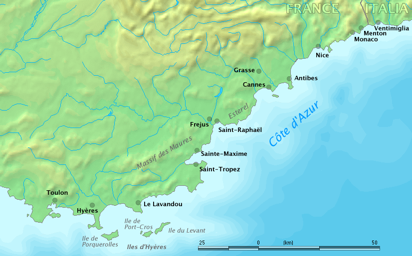
Map of Côte d'Azur, France
Original work by Markus Bernet, background map courtesy of www.demis.nl[dead link].

|
이 파일을 사용하지 말고, 대신 File:Côte d’Azur overview map.png을 사용해 주시기 바랍니다.
|

|
This image is in the public domain because it came from the site https://www.demis.nl/products/web-map-server/examples/ and was released by the copyright holder. Permission is granted to copy, distribute and/or modify this map since it is based on free of copyright images from: www.demis.nl. See also approval email on de.wp and its clarification.
|
| This work has been released into the public domain by its copyright holder, www.demis.nl. This applies worldwide. 만약 저작권의 포기가 법률적으로 가능하지 않은 경우, www.demis.nl은 이 작품을 법적으로 허용되는 한도 내에서 누구나 자유롭게 어떤 목적으로도 제한 없이 사용할 수 있도록 허용합니다.
|
derivative works
이 파일은 다음으로 파생됨: Fort de Brégançon location.png
파일 역사
날짜/시간 링크를 클릭하면 해당 시간의 파일을 볼 수 있습니다.
| 날짜/시간 | 섬네일 | 크기 | 사용자 | 설명 | |
|---|---|---|---|---|---|
| 현재 | 2006년 3월 28일 (화) 18:32 | | 826 × 514 (453 KB) | MRB | Map of ''Côte d'Azur'', France Original work by Markus Bernet, background map courtesy of [http://www.demis.nl/mapserver/mapper.asp www.demis.nl]. {{Demis-pd}} |
이 파일을 사용하는 문서
이 파일을 사용하는 문서가 없습니다.
이 파일을 사용하고 있는 모든 위키의 문서 목록
다음 위키에서 이 파일을 사용하고 있습니다:
- ar.wikipedia.org에서 이 파일을 사용하고 있는 문서 목록
- bg.wikipedia.org에서 이 파일을 사용하고 있는 문서 목록
- el.wikipedia.org에서 이 파일을 사용하고 있는 문서 목록
- en.wikipedia.org에서 이 파일을 사용하고 있는 문서 목록
- fa.wikipedia.org에서 이 파일을 사용하고 있는 문서 목록
- fr.wikipedia.org에서 이 파일을 사용하고 있는 문서 목록
- uk.wikipedia.org에서 이 파일을 사용하고 있는 문서 목록