
파일:British Empire.png
미리 보기 크기: 800 × 351 픽셀 다른 해상도: 320 × 140 픽셀 | 640 × 281 픽셀 | 1,425 × 625 픽셀
원본 파일 (1,425 × 625 픽셀, 파일 크기: 41 KB, MIME 종류: image/png)
파일 설명
| 설명 |
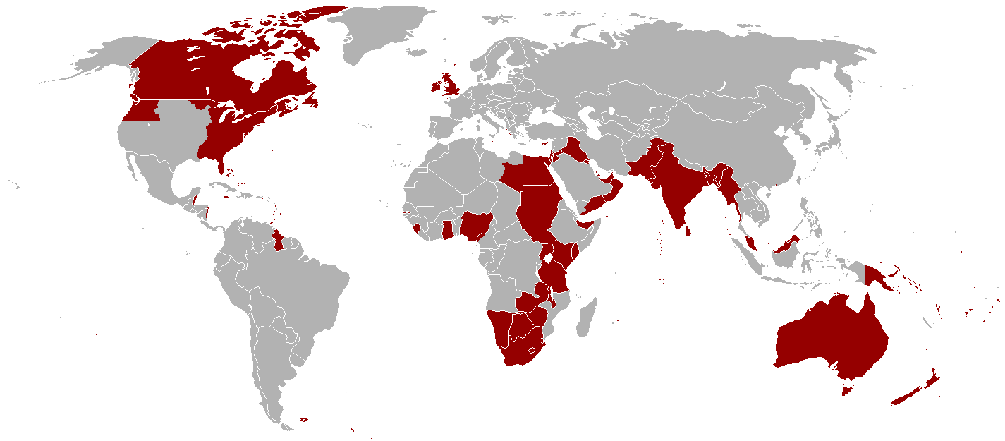
English: Map of all the offical territorial claims of the British Empire that it ever held. (Do keep in mind that Oregon Territory was shared with the United States and south-east Libya was shared with Italy in a disputed part of what was then known as Italian North Africa). |
| 날짜 | 2005년 1월 2일 (원본 올리기 일시) |
| 출처 | Information gathered throughout the English Wikipedia |
| 저자 | Ramirez72, Andersmusician, Vadac |
| 저작권 (이 파일을 인용하기) |
Released into the public domain (by the author). |
라이선스
이 파일은 크리에이티브 커먼즈 저작자표시-동일조건변경허락 2.5 일반 라이선스로 배포됩니다.
- 이용자는 다음의 권리를 갖습니다:
- 공유 및 이용 – 저작물의 복제, 배포, 전시, 공연 및 공중송신
- 재창작 – 저작물의 개작, 수정, 2차적저작물 창작
- 다음과 같은 조건을 따라야 합니다:
- 저작자표시 – 적절한 저작자 표시를 제공하고, 라이센스에 대한 링크를 제공하고, 변경사항이 있는지를 표시해야 합니다. 당신은 합리적인 방식으로 표시할 수 있지만, 어떤 방식으로든 사용권 허가자가 당신 또는 당신의 사용을 지지하는 방식으로 표시할 수 없습니다.
- 동일조건변경허락 – 만약 당신이 이 저작물을 리믹스 또는 변형하거나 이 저작물을 기반으로 제작하는 경우, 당신은 당신의 기여물을 원저작물과 동일하거나 호환 가능한 라이선스에 따라 배포하여야 합니다.
파일 역사
날짜/시간 링크를 클릭하면 해당 시간의 파일을 볼 수 있습니다.
| 날짜/시간 | 섬네일 | 크기 | 사용자 | 설명 | |
|---|---|---|---|---|---|
| 현재 | 2021년 10월 31일 (일) 17:16 | | 1,425 × 625 (41 KB) | Randomastwritter | jubaland |
| 2010년 12월 14일 (화) 10:16 |  | 1,425 × 625 (51 KB) | Vadac | Clearer version which includes a huge amount of missing territory in the western region of British America which was part of the British Empire from 1763-1783. | |
| 2005년 1월 2일 (일) 10:05 |  | 1,357 × 628 (24 KB) | Nickshanks | Territories once under administration from London. Excludes parts of France (not sure what to include), British Antarctic Territories, and many small Pacific and Indian Ocean islands. {{PD}} |
이 파일을 사용하는 문서
이 파일을 사용하는 문서가 없습니다.
이 파일을 사용하고 있는 모든 위키의 문서 목록
다음 위키에서 이 파일을 사용하고 있습니다:
- da.wikipedia.org에서 이 파일을 사용하고 있는 문서 목록
- en.wikipedia.org에서 이 파일을 사용하고 있는 문서 목록
- he.wikipedia.org에서 이 파일을 사용하고 있는 문서 목록
- nn.wikipedia.org에서 이 파일을 사용하고 있는 문서 목록
- no.wikipedia.org에서 이 파일을 사용하고 있는 문서 목록