
파일:AustriaHungaryWWI.gif
미리 보기 크기: 681 × 599 픽셀 다른 해상도: 273 × 240 픽셀 | 545 × 480 픽셀 | 776 × 683 픽셀
원본 파일 (776 × 683 픽셀, 파일 크기: 98 KB, MIME 종류: image/gif)
파일 설명
| 설명 |
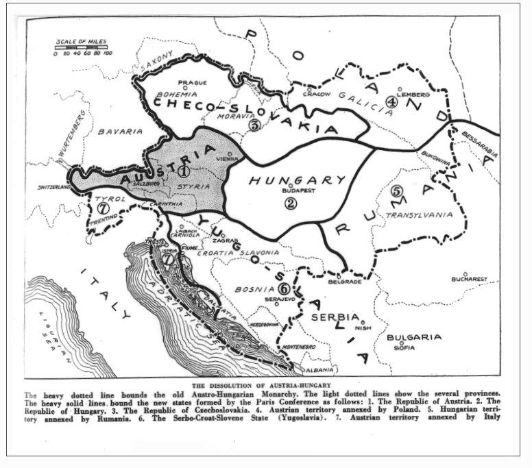
English: Drafted borders of Austria-Hungary in the Treaty of Trianon and Saint Germain. (map as published in the magazine; may differ from the later implementation of the treaty) |
| 날짜 | |
| 출처 |
https://babel.hathitrust.org/cgi/pt?id=iau.31858029095456;view=1up;seq=427 (Jump to 391) The Independent (New York), June 14, vol. 98, 1919, p. 391 (Primary source, if any, not cited) |
| 저자 | The Independent |
기존 올리기 기록
The original description page was here. All following user names refer to en.wikipedia.
- 2009-01-20 00:44 Bizso 776×683 (100493 bytes)
라이선스
| 이 파일은 크리에이티브 커먼즈 저작자표시-동일조건변경허락 3.0 Unported 라이선스로 배포됩니다. 면책 조항이 적용됩니다. | ||
| ||
| 이 라이선스 틀은 GFDL 라이선스 변경의 일부로 이 파일에 추가되었습니다. |

|
GNU 자유 문서 사용 허가서 1.2판 또는 자유 소프트웨어 재단에서 발행한 이후 판의 규정에 따라 본 문서를 복제하거나 개작 및 배포할 수 있습니다. 본 문서에는 변경 불가 부분이 없으며, 앞 표지 구절과 뒷 표지 구절도 없습니다. 본 사용 허가서의 전체 내용은 GNU 자유 문서 사용 허가서 부분에 포함되어 있습니다. 면책 조항이 적용됩니다. |
or
This media file is in the public domain in the United States. This applies to U.S. works where the copyright has expired, often because its first publication occurred prior to January 1, 1929, and if not then due to lack of notice or renewal. See this page for further explanation.
|
 | |
 |
This image might not be in the public domain outside of the United States; this especially applies in the countries and areas that do not apply the rule of the shorter term for US works, such as Canada, Mainland China (not Hong Kong or Macao), Germany, Mexico, and Switzerland. The creator and year of publication are essential information and must be provided. See Wikipedia:Public domain and Wikipedia:Copyrights for more details.
|
파일 역사
날짜/시간 링크를 클릭하면 해당 시간의 파일을 볼 수 있습니다.
| 날짜/시간 | 섬네일 | 크기 | 사용자 | 설명 | |
|---|---|---|---|---|---|
| 현재 | 2022년 1월 26일 (수) 14:39 | | 776 × 683 (98 KB) | GPinkerton | Reverted to version as of 22:53, 20 January 2009 (UTC) COM:CROP, manipulation of historical images |
| 2021년 12월 27일 (월) 20:11 |  | 762 × 642 (97 KB) | Claude Zygiel | Sub-Carpathian Ruthenia never was Polish, this is not a "historical map" but an error of a newspaper: correcting it is not "manipulation". | |
| 2021년 9월 27일 (월) 13:31 |  | 776 × 683 (98 KB) | GPinkerton | Reverted to version as of 22:53, 20 January 2009 (UTC) COM:CROP, manipulation of historical images | |
| 2020년 7월 23일 (목) 18:27 |  | 762 × 642 (97 KB) | Claude Zygiel | Better (see [https://commons.wikimedia.org/wiki/File:Dissolution_of_Austria-Hungary.png]) | |
| 2009년 1월 21일 (수) 07:53 |  | 776 × 683 (98 KB) | Bizso | {{Information |Description={{en|New hand-drawn borders of Austria-Hungary in the Treaty of Trianon and Saint Germain.}} |Source=Transferred from [http://en.wikipedia.org en.wikipedia]; transfer was stated to be made by User:Bizso.<br/> (Original text |
이 파일을 사용하는 문서
다음 문서 1개가 이 파일을 사용하고 있습니다:
이 파일을 사용하고 있는 모든 위키의 문서 목록
다음 위키에서 이 파일을 사용하고 있습니다:
- azb.wikipedia.org에서 이 파일을 사용하고 있는 문서 목록
- bg.wikipedia.org에서 이 파일을 사용하고 있는 문서 목록
- ca.wikipedia.org에서 이 파일을 사용하고 있는 문서 목록
- cy.wikipedia.org에서 이 파일을 사용하고 있는 문서 목록
- el.wikipedia.org에서 이 파일을 사용하고 있는 문서 목록
- en.wikipedia.org에서 이 파일을 사용하고 있는 문서 목록
- ga.wikipedia.org에서 이 파일을 사용하고 있는 문서 목록
- gl.wikipedia.org에서 이 파일을 사용하고 있는 문서 목록
- he.wikipedia.org에서 이 파일을 사용하고 있는 문서 목록
- hr.wikipedia.org에서 이 파일을 사용하고 있는 문서 목록
- hy.wikipedia.org에서 이 파일을 사용하고 있는 문서 목록
- id.wikipedia.org에서 이 파일을 사용하고 있는 문서 목록
- it.wikipedia.org에서 이 파일을 사용하고 있는 문서 목록
- lv.wikipedia.org에서 이 파일을 사용하고 있는 문서 목록
- pnb.wikipedia.org에서 이 파일을 사용하고 있는 문서 목록
- pt.wikipedia.org에서 이 파일을 사용하고 있는 문서 목록
- ru.wikipedia.org에서 이 파일을 사용하고 있는 문서 목록
- sh.wikipedia.org에서 이 파일을 사용하고 있는 문서 목록
- simple.wikipedia.org에서 이 파일을 사용하고 있는 문서 목록
- sk.wikipedia.org에서 이 파일을 사용하고 있는 문서 목록
- th.wikipedia.org에서 이 파일을 사용하고 있는 문서 목록
- ur.wikipedia.org에서 이 파일을 사용하고 있는 문서 목록
- vi.wikipedia.org에서 이 파일을 사용하고 있는 문서 목록
- zh.wikipedia.org에서 이 파일을 사용하고 있는 문서 목록