
파일:Atu feb 21 2011.jpg

미리 보기 크기: 459 × 599 픽셀 다른 해상도: 184 × 240 픽셀 | 368 × 480 픽셀 | 588 × 768 픽셀 | 784 × 1,024 픽셀 | 1,569 × 2,048 픽셀 | 7,200 × 9,400 픽셀
원본 파일 (7,200 × 9,400 픽셀, 파일 크기: 8.58 MB, MIME 종류: image/jpeg)
| 주의 | 이 그림은 크기가 상당히 크며, 일부 브라우저의 경우 그림을 실제 크기로 표시할 때 프로그램이 멈출 수 있습니다. 이 경우, '최대 해상도' 링크 위에서 마우스 오른쪽 버튼을 눌러서 컴퓨터 파일로 저장한 다음, 포토샵이나 GIMP 같은 편집기를 이용해서 파일을 열어 주세요. |
|---|
파일 설명
| 설명 |
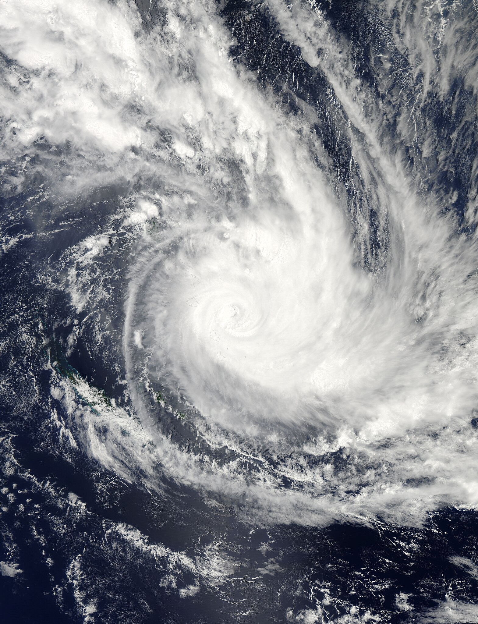
English: Tropical Cyclone Atu raged over the southern Pacific Ocean in late February 2011, stretching from New Caledonia to Fiji. The U.S. Navy’s Joint Typhoon Warning Center (JTWC) reported that, as of 8:00 p.m. local time on February 21, Atu was located roughly 115 nautical miles (215 kilometers) east-southeast of Port Vila, Vanuatu. The storm had maximum sustained winds of 100 knots (185 kilometers per hour) and gusts up to 125 knots (230 kilometers per hour).
The Moderate Resolution Imaging Spectroradiometer (MODIS) on NASA’s Aqua satellite captured this natural-color image around 11:30 a.m. local time on February 21, 2011. The center of the storm appears just east of the Vanuatu archipelago. The JTWC forecast that Atu would accelerate roughly toward the southeast, and would probably intensify slightly over the next 24 hours. After about 36 hours, however, Atu was expected to quickly weaken, thanks to increasing vertical wind shear and lower sea surface temperatures. |
| 날짜 | |
| 출처 | http://earthobservatory.nasa.gov/NaturalHazards/view.php?id=49381 |
| 저자 | NASA images courtesy Jeff Schmaltz, MODIS Rapid Response Team at NASA GSFC. Caption by Michon Scott. |
라이선스
| 이 파일은 NASA에서 제작하였으므로 퍼블릭 도메인입니다. NASA의 저작권 정책에 따르면 NASA의 자료는 명시하지 않는 이상 저작권의 보호를 받지 않습니다. (Template:PD-USGov, 또는 NASA 저작권 정책 문서, JPL 그림 사용 정책을 참고하세요.) | ||
 |
주의사항:
|
파일 역사
날짜/시간 링크를 클릭하면 해당 시간의 파일을 볼 수 있습니다.
| 날짜/시간 | 섬네일 | 크기 | 사용자 | 설명 | |
|---|---|---|---|---|---|
| 현재 | 2023년 8월 13일 (일) 22:59 | | 7,200 × 9,400 (8.58 MB) | Nino Marakot | Original image |
| 2011년 2월 22일 (화) 04:50 |  | 7,200 × 9,400 (11.26 MB) | Supportstorm | {{Information |Description ={{en|1=Tropical Cyclone Atu raged over the southern Pacific Ocean in late February 2011, stretching from New Caledonia to Fiji. The U.S. Navy’s Joint Typhoon Warning Center (JTWC) reported that, as of 8:00 p.m. local time |
이 파일을 사용하는 문서
다음 문서 1개가 이 파일을 사용하고 있습니다:
이 파일을 사용하고 있는 모든 위키의 문서 목록
다음 위키에서 이 파일을 사용하고 있습니다:
- en.wikipedia.org에서 이 파일을 사용하고 있는 문서 목록
- pt.wikipedia.org에서 이 파일을 사용하고 있는 문서 목록
- ru.wikipedia.org에서 이 파일을 사용하고 있는 문서 목록
- zh.wikipedia.org에서 이 파일을 사용하고 있는 문서 목록