
파일:Atlantic cable Map.jpg
미리 보기 크기: 800 × 322 픽셀 다른 해상도: 320 × 129 픽셀 | 640 × 257 픽셀
원본 파일 (1,493 × 600 픽셀, 파일 크기: 163 KB, MIME 종류: image/jpeg)
| 설명 |
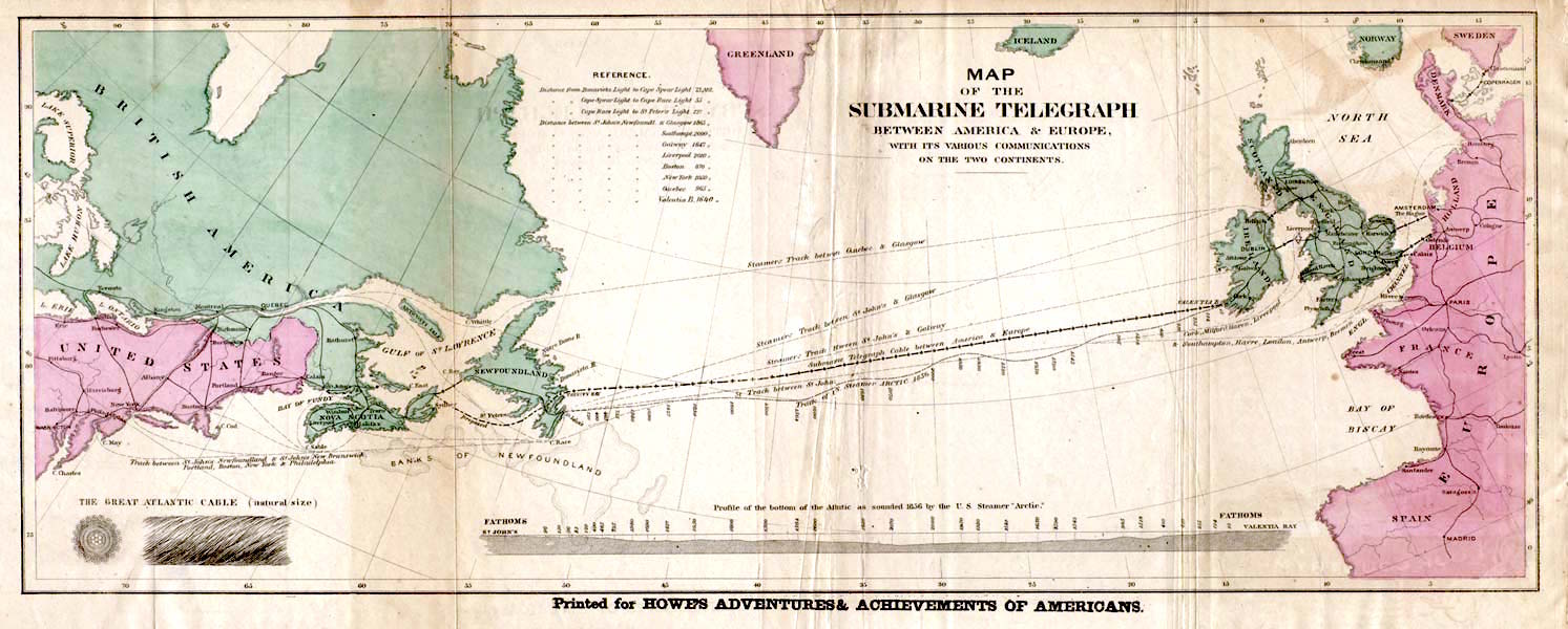
English: Map of the 1858 Atlantic Cable route (from http://atlantic-cable.com/Maps/index.htm).
Français : Carte des routes de câbles sous-marins transatlatiques de 1858.
Русский: Карта прокладки телеграфного кабеля через Атлантику в 1858 г.
Українська: Карта першого трансатлантичного телеграфного кабеля в 1858 р. |
| 날짜 | the 1858 |
| 출처 | Howe's Adventures & Achievements of Americans; en:Image:Atlantic_cable_Map.jpg |
| 저자 | 미상 |
| 저작권 (이 파일을 인용하기) |
English: Image is out of copyright, but the scan used here was sourced from http://atlantic-cable.com/Maps/index.htm without my permission (I am the site owner). I grant permission for use of the scan on Wikipedia.
Українська: Зображення не захищене авторським правом, але сканування, яке тут використовується, було отримано з http://atlantic-cable.com/Maps/index.htm без мого дозволу (я власник сайту). Надаю дозвіл на використання сканування у Вікіпедії. |
|
이 작품은 미국, 그리고 저작권 보호 기간이 저작자 사후 70년, 또는 그 이하인 모든 국가에서 퍼블릭 도메인입니다.
| |
| 이 저작물은 모든 저작인접권을 포함한 저작권법하의 규제로부터 자유로운 것으로 확인되었습니다. | |
This media file is in the public domain in the United States. This applies to U.S. works where the copyright has expired, often because its first publication occurred prior to January 1, 1929, and if not then due to lack of notice or renewal. See this page for further explanation.
|
 | |
 |
This image might not be in the public domain outside of the United States; this especially applies in the countries and areas that do not apply the rule of the shorter term for US works, such as Canada, Mainland China (not Hong Kong or Macao), Germany, Mexico, and Switzerland. The creator and year of publication are essential information and must be provided. See Wikipedia:Public domain and Wikipedia:Copyrights for more details.
|
파일 역사
날짜/시간 링크를 클릭하면 해당 시간의 파일을 볼 수 있습니다.
| 날짜/시간 | 섬네일 | 크기 | 사용자 | 설명 | |
|---|---|---|---|---|---|
| 현재 | 2018년 1월 29일 (월) 23:35 | 1,493 × 600 (163 KB) | Soerfm | Color, brightness | |
| 2006년 3월 10일 (금) 00:53 | 1,493 × 600 (136 KB) | Jailbird | Map of the 1858 Atlantic Cable route from Frank Leslie's Illustrated Newspaper, August 21, 1858 from en:Image:Atlantic_cable_Map.jpg {{PD-Old}} |
이 파일을 사용하는 문서
다음 문서 2개가 이 파일을 사용하고 있습니다:
이 파일을 사용하고 있는 모든 위키의 문서 목록
다음 위키에서 이 파일을 사용하고 있습니다:
- az.wikipedia.org에서 이 파일을 사용하고 있는 문서 목록
- be-tarask.wikipedia.org에서 이 파일을 사용하고 있는 문서 목록
- bs.wikipedia.org에서 이 파일을 사용하고 있는 문서 목록
- ca.wikipedia.org에서 이 파일을 사용하고 있는 문서 목록
- cs.wikipedia.org에서 이 파일을 사용하고 있는 문서 목록
- de.wikipedia.org에서 이 파일을 사용하고 있는 문서 목록
- en.wikipedia.org에서 이 파일을 사용하고 있는 문서 목록
- en.wikibooks.org에서 이 파일을 사용하고 있는 문서 목록
- en.wikivoyage.org에서 이 파일을 사용하고 있는 문서 목록
- eo.wikipedia.org에서 이 파일을 사용하고 있는 문서 목록
- es.wikipedia.org에서 이 파일을 사용하고 있는 문서 목록
- et.wikipedia.org에서 이 파일을 사용하고 있는 문서 목록
- eu.wikipedia.org에서 이 파일을 사용하고 있는 문서 목록
- fa.wikipedia.org에서 이 파일을 사용하고 있는 문서 목록
- fi.wikipedia.org에서 이 파일을 사용하고 있는 문서 목록
- fr.wikipedia.org에서 이 파일을 사용하고 있는 문서 목록
- 1866
- Câble sous-marin
- Extel
- Câbles télégraphiques transatlantiques
- Discussion:Câbles télégraphiques transatlantiques
- Wikipédia:Statistiques des anecdotes de la page d'accueil/Visibilité des anecdotes (2021)
- Discussion:Câbles télégraphiques transatlantiques/LSV 19995
- Wikipédia:Statistiques des anecdotes de la page d'accueil/Visibilité des anecdotes (2021)/2021 04
- Projet:Aide et accueil/Twitter/Tweets/archives/avril 2021
- Wikipédia:Le saviez-vous ?/Archives/2021
- Wikipédia:Le Bistro/5 août 2022
- Télégraphie électrique
- gd.wikipedia.org에서 이 파일을 사용하고 있는 문서 목록
- id.wikipedia.org에서 이 파일을 사용하고 있는 문서 목록
- io.wikipedia.org에서 이 파일을 사용하고 있는 문서 목록
- it.wikipedia.org에서 이 파일을 사용하고 있는 문서 목록
- ja.wikipedia.org에서 이 파일을 사용하고 있는 문서 목록
이 파일의 더 많은 사용 내역을 봅니다.