
파일:Asou-Bay ria coast aerial photograph.JPG
미리 보기 크기: 800 × 599 픽셀 다른 해상도: 320 × 239 픽셀 | 640 × 479 픽셀 | 1,024 × 766 픽셀 | 1,280 × 958 픽셀 | 2,560 × 1,915 픽셀 | 3,487 × 2,609 픽셀
원본 파일 (3,487 × 2,609 픽셀, 파일 크기: 3.63 MB, MIME 종류: image/jpeg)
파일 설명
| 설명 |
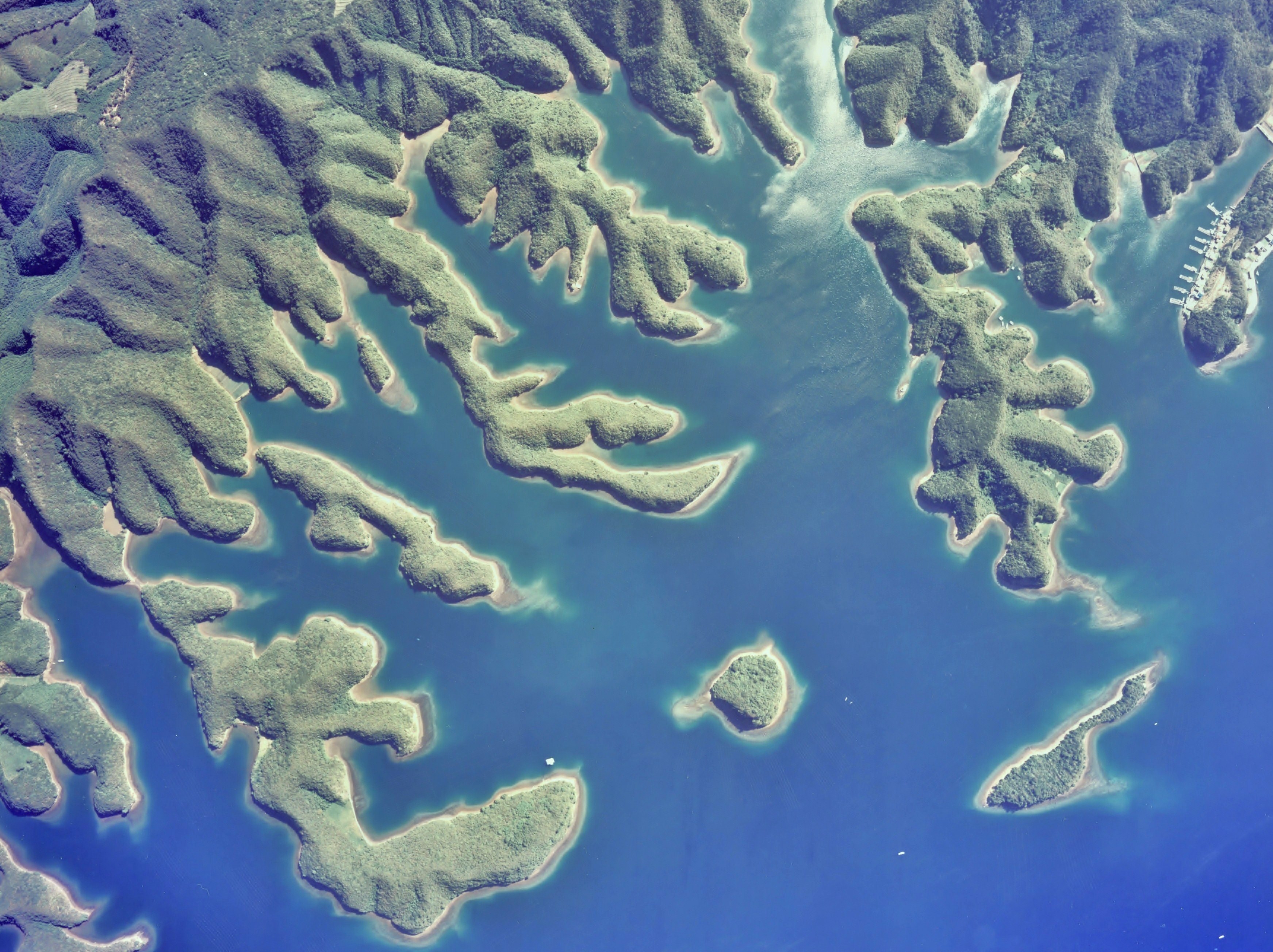
English: Gulf of Asou-Bay ria coast(drowned valley)aerial photograph in Tsushima Island Japan
日本語: 対馬、浅茅湾大千切島付近のリアス式海岸(溺れ谷)地形の空中写真。Cku-77-1_c16_13-1を使用。 |
| 날짜 | |
| 출처 | 国土情報ウェブマッピングシステム |
| 저자 | 国土交通省 |
| 대상 위치 | | 이 지역의 다른 사진을 보기: OpenStreetMap |
|---|
라이선스

|
이 파일의 저작권자인 일본 국토교통성은 저작권자를 명시하는 조건에 따라 누구에게나 어떤 목적으로든지 제한 없이 사용할 수 있도록 허용하였습니다. 재배포나 이차적 저작물 작성 및 상업적 이용 등이 허용됩니다. |
저작자표시:
Copyright © National Land Image Information (Color Aerial Photographs), Ministry of Land, Infrastructure, Transport and Tourism
|
 |
This image is copyrighted by the Ministry of Land, Infrastructure, Transport and Tourism of Japan. For terms of use, see the stipulation to use of National Land Information (in Japanese) and message from MLIT (in Japanese and English). When you display this image on an article, include the following phrase in the description: "Made based on National Land Image Information (Color Aerial Photographs), Ministry of Land, Infrastructure, Transport and Tourism".
|
파일 역사
날짜/시간 링크를 클릭하면 해당 시간의 파일을 볼 수 있습니다.
| 날짜/시간 | 섬네일 | 크기 | 사용자 | 설명 | |
|---|---|---|---|---|---|
| 현재 | 2010년 12월 4일 (토) 11:11 | | 3,487 × 2,609 (3.63 MB) | さかおり | {{Information |Description={{en|1=Gulf of Asou-Bay ria coast(drowned valley)aerial photograph in Tsushima Island Japan {{en|1={{ja|1=対馬、浅茅湾大千切島付近のリアス式海岸(溺れ谷)地形の空中写真。Cku-77-1_c16_13-1を� |
이 파일을 사용하는 문서
다음 문서 1개가 이 파일을 사용하고 있습니다:
이 파일을 사용하고 있는 모든 위키의 문서 목록
다음 위키에서 이 파일을 사용하고 있습니다:
- bn.wikipedia.org에서 이 파일을 사용하고 있는 문서 목록
- en.wikipedia.org에서 이 파일을 사용하고 있는 문서 목록
- ja.wikipedia.org에서 이 파일을 사용하고 있는 문서 목록
- ms.wikipedia.org에서 이 파일을 사용하고 있는 문서 목록
- nl.wikipedia.org에서 이 파일을 사용하고 있는 문서 목록
- nl.wiktionary.org에서 이 파일을 사용하고 있는 문서 목록
- no.wikipedia.org에서 이 파일을 사용하고 있는 문서 목록