
파일:Asia Europe transcontinental.png

미리 보기 크기: 763 × 599 픽셀 다른 해상도: 306 × 240 픽셀 | 611 × 480 픽셀 | 978 × 768 픽셀 | 1,268 × 996 픽셀
원본 파일 (1,268 × 996 픽셀, 파일 크기: 46 KB, MIME 종류: image/png)
| 설명 |
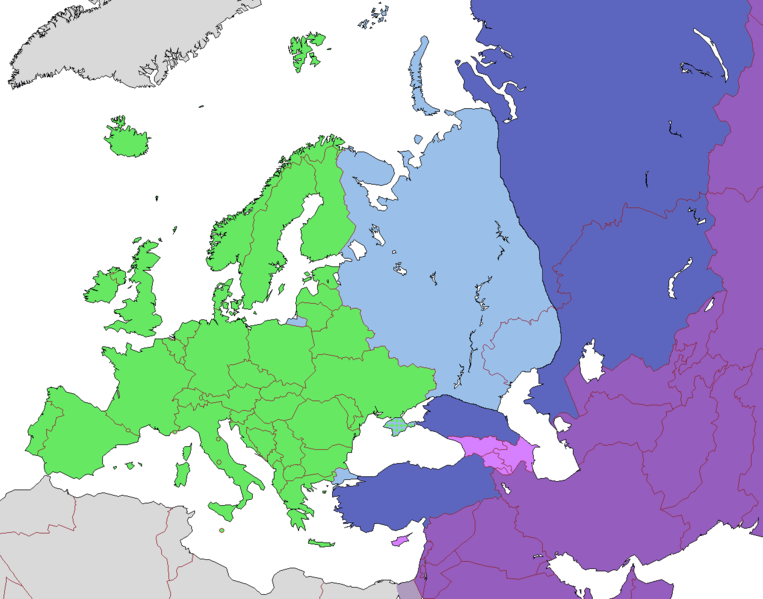
English: Map of Europe, indicating continental boundary (by Britannica and Great Soviet Encyclopedia) and transcontinental states.
States geographically in Europe (excepting overseas possessions)
Transcontinental states, European territory
Transcontinental states, Asian territory
Asian countries, sometimes referred to as Europe according to political, economic, and historical and cultural criteria (Azerbaijan, Armenia, Georgia, Cyprus)
Geographically Asian states (island states of Cyprus and Bahrain usually grouped with Asia geographically)
Asian part of Egypt Русский: Карта Европы с указанием границ частей света (по БСЭ и Британнике) и трансконтинентальных государств.
Государства, расположенные в Европе (за исключением заморских владений)
Трансконтинентальные государства, европейская территория
Трансконтинентальные государства, азиатская территория
Государства Азии, иногда относимые к Европе по политическим, экономическим, и историко-культурным критериям
Государства, расположенные в Азии
Азиатская часть Египта |
| 날짜 | |
| 출처 | |
| 저자 |
.png)
라이선스
이 파일은 크리에이티브 커먼즈 저작자표시-동일조건변경허락 3.0 Unported 라이선스로 배포됩니다.
- 이용자는 다음의 권리를 갖습니다:
- 공유 및 이용 – 저작물의 복제, 배포, 전시, 공연 및 공중송신
- 재창작 – 저작물의 개작, 수정, 2차적저작물 창작
- 다음과 같은 조건을 따라야 합니다:
- 저작자표시 – 적절한 저작자 표시를 제공하고, 라이센스에 대한 링크를 제공하고, 변경사항이 있는지를 표시해야 합니다. 당신은 합리적인 방식으로 표시할 수 있지만, 어떤 방식으로든 사용권 허가자가 당신 또는 당신의 사용을 지지하는 방식으로 표시할 수 없습니다.
- 동일조건변경허락 – 만약 당신이 이 저작물을 리믹스 또는 변형하거나 이 저작물을 기반으로 제작하는 경우, 당신은 당신의 기여물을 원저작물과 동일하거나 호환 가능한 라이선스에 따라 배포하여야 합니다.
| 주석 | 이 이미지에는 주석이 있습니다: 공용에서 주석을 보기 |
파일 역사
날짜/시간 링크를 클릭하면 해당 시간의 파일을 볼 수 있습니다.
| 날짜/시간 | 섬네일 | 크기 | 사용자 | 설명 | |
|---|---|---|---|---|---|
| 현재 | 2022년 11월 14일 (월) 19:23 | | 1,268 × 996 (46 KB) | Рагин1987 | Highlighted with a light purple hue the countries of Asia, sometimes attributed to Europe according to political, economic, and historical and cultural criteria (Transcaucasia, Cyprus). |
| 2022년 8월 29일 (월) 21:02 |  | 1,268 × 996 (46 KB) | Рагин1987 | Small correction | |
| 2020년 2월 18일 (화) 16:03 |  | 1,268 × 996 (56 KB) | Insider | fix: mixed color. not dark blue | |
| 2020년 2월 18일 (화) 15:55 |  | 1,268 × 996 (60 KB) | Insider | Reverted to version as of 07:01, 13 October 2014 (UTC) Crimea that is Europe | |
| 2020년 2월 10일 (월) 18:04 |  | 1,268 × 996 (84 KB) | Compu wiki | Крым — это Россия. Crimea is Russia. | |
| 2014년 10월 13일 (월) 16:01 |  | 1,268 × 996 (60 KB) | Insider | Reverted to version as of 10:10, 1 July 2014 Crimea that is Europe | |
| 2014년 10월 11일 (토) 21:31 |  | 1,268 × 996 (84 KB) | Michael1238 | Crimea | |
| 2014년 7월 1일 (화) 19:10 |  | 1,268 × 996 (60 KB) | Insider | {{Information |Description={{en|1= Map of Europe, indicating continental boundary and transcontinental states. {{legend|#67e836|States geographically in Europe (excepting overseas possessions; island states UK, Ireland, Iceland and Malta usually group... |
이 파일을 사용하는 문서
이 파일을 사용하는 문서가 없습니다.
이 파일을 사용하고 있는 모든 위키의 문서 목록
다음 위키에서 이 파일을 사용하고 있습니다:
- hy.wikipedia.org에서 이 파일을 사용하고 있는 문서 목록
- kk.wikipedia.org에서 이 파일을 사용하고 있는 문서 목록
- ru.wikipedia.org에서 이 파일을 사용하고 있는 문서 목록