
파일:Aksai Chin Sino-Indian border map.png

원본 파일 (624 × 872 픽셀, 파일 크기: 102 KB, MIME 종류: image/png)
파일 설명

|
이 그림은 벡터 그래픽 버전(SVG)이 있습니다. 래스터(비트맵) 그림 대신 벡터 그래픽 그림을 사용하는 것이 좋습니다.
File:Aksai Chin Sino-Indian border map.png → File:Aksai Chin Sino-Indian border map.svg
|
 |
| 설명 |
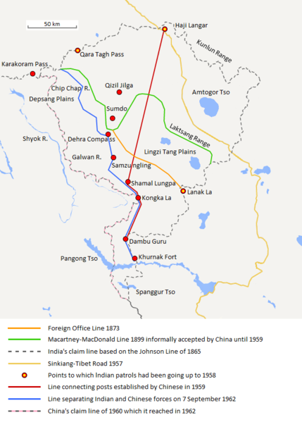
English: The map shows the Indian and Chinese claims of the border in the Aksai Chin region, the Macartney-MacDonald line, the Foreign Office Line, as well as the progress of Chinese forces as they occupied areas during the Sino-Indian War. |
| 날짜 | |
| 출처 | 자작 |
| 저자 | The Discoverer |
The Macartney-MacDonald line is described as follows: "From the Karakoram Pass the crests of the range run nearly east for about half a degree, and then turn south to a little below the 35th parallel.. Rounding... the source of the Karakash, the line of hills to be followed runs north-east to a point east of Kizil Jilga and from there, in a south-easterly direction, follows the Lak Tsung (Lokzhung) Range until that meets a spur.. which has hitherto been shown on our maps as the eastern boundary of Ladakh.[1]
The Macartney-MacDonald line was never accepted by China, although they informally indicated acceptance on certain occasions:
- Woodman, Dorothy (1969년) Himalayan Frontiers: A Political Review of British, Chinese, Indian, and Russian Rivalries, Praeger, p. 102 "The proposed boundary seems never to have been considered in the same form again until Alastair Lamb revived it in 1964."
- Lamb, Alastair (1965). "Treaties, Maps and the Western Sector of the Sino-Indian Boundary Dispute". The Australian Year Book of International Law. "Unfortunately, the Chinese never replied formally to the note, though they indicated informally on a number of occasions their agreement as to its boundary alignment."
In 1959, Chou confirmed the new Chinese claim line to Nehru.
References: [2] archive copy at the Wayback Machine [3] [4] [5] [6] Map on last page archive copy at the Wayback Machine [7]
![[2]](http://cpasindia.org/images/sino-india1.jpg)
![[3]](http://www.frontline.in/static/html/fl2018/images/20030912002104801.jpg)
![[4]](http://www.frontline.in/static/html/fl2018/images/20030912002104802.jpg)
![[5]](http://www.frontline.in/static/html/fl2320/images/20061020001608505.jpg)
![[6]](http://www.indiandefencereview.com/wp-content/uploads/2013/06/Aksai-Chin-GOI-Map.jpg)
라이선스
- 이용자는 다음의 권리를 갖습니다:
- 공유 및 이용 – 저작물의 복제, 배포, 전시, 공연 및 공중송신
- 재창작 – 저작물의 개작, 수정, 2차적저작물 창작
- 다음과 같은 조건을 따라야 합니다:
- 저작자표시 – 적절한 저작자 표시를 제공하고, 라이센스에 대한 링크를 제공하고, 변경사항이 있는지를 표시해야 합니다. 당신은 합리적인 방식으로 표시할 수 있지만, 어떤 방식으로든 사용권 허가자가 당신 또는 당신의 사용을 지지하는 방식으로 표시할 수 없습니다.
- 동일조건변경허락 – 만약 당신이 이 저작물을 리믹스 또는 변형하거나 이 저작물을 기반으로 제작하는 경우, 당신은 당신의 기여물을 원저작물과 동일하거나 호환 가능한 라이선스에 따라 배포하여야 합니다.
파일 역사
날짜/시간 링크를 클릭하면 해당 시간의 파일을 볼 수 있습니다.
| 날짜/시간 | 섬네일 | 크기 | 사용자 | 설명 | |
|---|---|---|---|---|---|
| 현재 | 2020년 9월 8일 (화) 05:06 | | 624 × 872 (102 KB) | The Discoverer | Removed Tibet-Sinkiang boundary, added label for Amtogor Tso. |
| 2020년 6월 9일 (화) 11:51 |  | 624 × 872 (102 KB) | MarkH21 | Intended change from the last edit (i.e. latest version with "informally" per references in talk discussion) | |
| 2020년 6월 9일 (화) 11:29 |  | 624 × 872 (101 KB) | MarkH21 | Reverted to version as of 00:21, 7 February 2018 (UTC) This was the previous version; the addition of “accepted by China until 1959” was the contested change, not the revert to the original description (the refs are also now dead, but previously said tacit acceptance which isn’t outright acceptance) | |
| 2018년 4월 24일 (화) 04:37 |  | 624 × 872 (102 KB) | The Discoverer | Reverted to version as of 09:10, 13 December 2017 (UTC) The file of 12 December removes a statement that is supported by the source. As per COM:OVERWRITE, "Controversial or contested changes should be uploaded to a separate filename" | |
| 2018년 2월 7일 (수) 09:21 |  | 624 × 872 (101 KB) | 樂號 | Reverted to version as of 23:05, 12 December 2017 (UTC) | |
| 2017년 12월 13일 (수) 18:10 |  | 624 × 872 (102 KB) | The Discoverer | Reverted to version as of 11:07, 19 February 2017 (UTC) The file of 12 December removes a statement that is supported by the source. As per COM:OVERWRITE, "Controversial or contested changes should be uploaded to a separate filename" | |
| 2017년 12월 13일 (수) 08:05 |  | 624 × 872 (101 KB) | 樂號 | Macartney–MacDonald Line is only proposed by Britain No official accept made by China | |
| 2017년 2월 19일 (일) 20:07 |  | 624 × 872 (102 KB) | The Discoverer | Added Karakoram Pass and Kunlun Range | |
| 2015년 4월 2일 (목) 00:26 |  | 624 × 872 (59 KB) | RokerHRO | optipng -o7 -i0 → 40.77% decrease | |
| 2014년 10월 3일 (금) 00:00 |  | 624 × 872 (99 KB) | The Discoverer | Uploaded correct file with scale added. |
이 파일을 사용하는 문서
다음 문서 1개가 이 파일을 사용하고 있습니다:
이 파일을 사용하고 있는 모든 위키의 문서 목록
다음 위키에서 이 파일을 사용하고 있습니다:
- ar.wikipedia.org에서 이 파일을 사용하고 있는 문서 목록
- ast.wikipedia.org에서 이 파일을 사용하고 있는 문서 목록
- as.wikipedia.org에서 이 파일을 사용하고 있는 문서 목록
- az.wikipedia.org에서 이 파일을 사용하고 있는 문서 목록
- bh.wikipedia.org에서 이 파일을 사용하고 있는 문서 목록
- bn.wikipedia.org에서 이 파일을 사용하고 있는 문서 목록
- ca.wikipedia.org에서 이 파일을 사용하고 있는 문서 목록
- de.wikipedia.org에서 이 파일을 사용하고 있는 문서 목록
- en.wikipedia.org에서 이 파일을 사용하고 있는 문서 목록
- es.wikipedia.org에서 이 파일을 사용하고 있는 문서 목록
- fr.wikipedia.org에서 이 파일을 사용하고 있는 문서 목록
- hi.wikipedia.org에서 이 파일을 사용하고 있는 문서 목록
- id.wikipedia.org에서 이 파일을 사용하고 있는 문서 목록
- it.wikipedia.org에서 이 파일을 사용하고 있는 문서 목록
- ja.wikipedia.org에서 이 파일을 사용하고 있는 문서 목록
- ka.wikipedia.org에서 이 파일을 사용하고 있는 문서 목록
- kn.wikipedia.org에서 이 파일을 사용하고 있는 문서 목록
- lv.wikipedia.org에서 이 파일을 사용하고 있는 문서 목록
- ml.wikipedia.org에서 이 파일을 사용하고 있는 문서 목록
- ms.wikipedia.org에서 이 파일을 사용하고 있는 문서 목록
- nl.wikipedia.org에서 이 파일을 사용하고 있는 문서 목록
- no.wikipedia.org에서 이 파일을 사용하고 있는 문서 목록
- or.wikipedia.org에서 이 파일을 사용하고 있는 문서 목록
- pl.wikipedia.org에서 이 파일을 사용하고 있는 문서 목록
- pt.wikipedia.org에서 이 파일을 사용하고 있는 문서 목록
- ro.wikipedia.org에서 이 파일을 사용하고 있는 문서 목록
- ru.wikipedia.org에서 이 파일을 사용하고 있는 문서 목록
- ru.wikinews.org에서 이 파일을 사용하고 있는 문서 목록
- sr.wikipedia.org에서 이 파일을 사용하고 있는 문서 목록
- ta.wikipedia.org에서 이 파일을 사용하고 있는 문서 목록
- te.wikipedia.org에서 이 파일을 사용하고 있는 문서 목록
- uk.wikipedia.org에서 이 파일을 사용하고 있는 문서 목록
- vi.wikipedia.org에서 이 파일을 사용하고 있는 문서 목록
이 파일의 더 많은 사용 내역을 봅니다.