
파일:2011-02-13-chemin.jpg

미리 보기 크기: 800 × 528 픽셀 다른 해상도: 320 × 211 픽셀 | 640 × 423 픽셀 | 1,024 × 676 픽셀 | 1,280 × 845 픽셀 | 2,560 × 1,691 픽셀 | 4,182 × 2,762 픽셀
원본 파일 (4,182 × 2,762 픽셀, 파일 크기: 11.3 MB, MIME 종류: image/jpeg)
파일 설명
| 설명 |
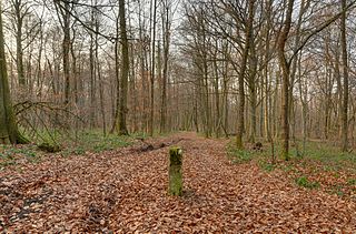
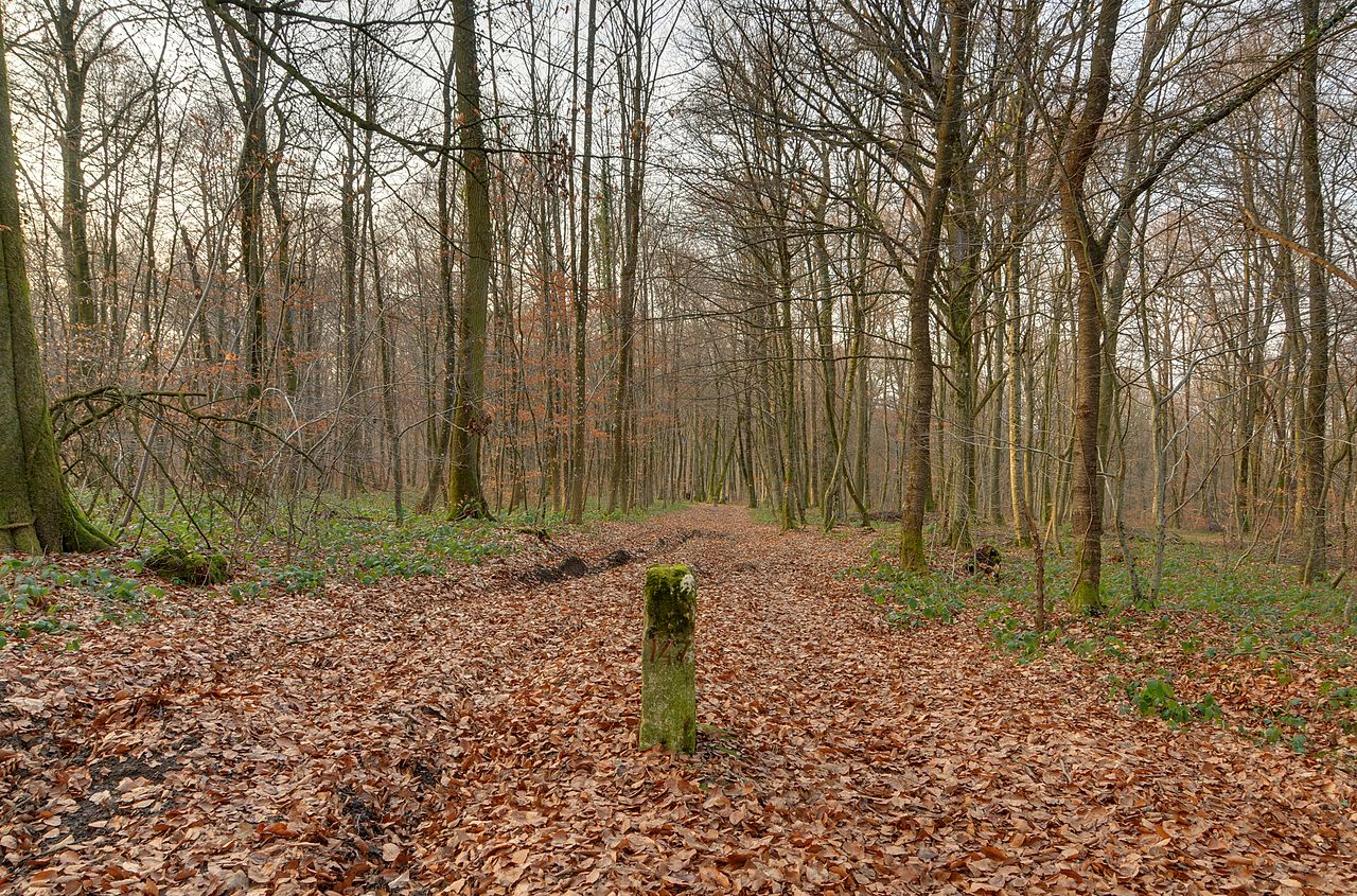
이 파일은 Commonist로 업로드되었습니다. 이 사진은 Nikon D300로 촬영하였습니다. Deutsch: Die schweizerisch-französische Grenze zwischen dem Departement Territoire-de-Belfort, Frankreich, und dem Kanton Jura, Schweiz. Auf diesem Bild ist links die Schweiz und rechts Frankreich. Eine zweite Grenzmarkierung ist im Hintergrund sichtbar. Dieses Foto ist ein Hochkontrastbild (HDR). English: The Swiss-French border between the department of Territoire-de-Belfort, France, and the canton of Jura, Switzerland. It is visible in this picture (left Switzerland, right France) – the second boundary marker is visible in the background (HDR) Español: La frontera franco-suiza, entre el cantón del Jura (Suiza, a la izquierda) y el departamento del Territorio de Belfort (Francia, a la derecha). La materializan los dos hitos fronterizos visibles en la foto (el segundo hito es visible en el fondo). (Imagen de gama dinámica amplia) Français : La frontière franco-suisse entre le département du Territoire-de-Belfort, France, et le canton du Jura, Suisse. Elle est matérialisée via les deux bornes frontières visibles sur cette photo (la 2e borne est visible en arrière-plan) (image à grande gamme dynamique). |
||||||||||||||||||||||
| 날짜 | |||||||||||||||||||||||
| 출처 | 자작 | ||||||||||||||||||||||
| 저자 |
|
||||||||||||||||||||||

| 카메라 위치 | | 이 지역의 다른 사진을 보기: OpenStreetMap |
|---|
라이선스
이 파일은 크리에이티브 커먼즈 저작자표시 3.0 Unported 라이선스로 배포됩니다.
- 이용자는 다음의 권리를 갖습니다:
- 공유 및 이용 – 저작물의 복제, 배포, 전시, 공연 및 공중송신
- 재창작 – 저작물의 개작, 수정, 2차적저작물 창작
- 다음과 같은 조건을 따라야 합니다:
- 저작자표시 – 적절한 저작자 표시를 제공하고, 라이센스에 대한 링크를 제공하고, 변경사항이 있는지를 표시해야 합니다. 당신은 합리적인 방식으로 표시할 수 있지만, 어떤 방식으로든 사용권 허가자가 당신 또는 당신의 사용을 지지하는 방식으로 표시할 수 없습니다.
| 주석 | 이 이미지에는 주석이 있습니다: 공용에서 주석을 보기 |
수상
|
이 이미지는 2011년 9월 3일의 오늘의 이미지로 선정되었습니다. 이미지 설명은 다음과 같습니다. English: The Swiss-French border is visible in this picture (left Switzerland, right France) – the second boundary marker is visible in the background (HDR) 다른 언어들:
Deutsch: Die französisch-schweizerische Grenze ist auf diesem Bild zu sehen (links Schweiz, rechts Frankreich) – der zweite Grenzstein ist im Hintergrund erkennbar (Hochkontrastbild) Eesti: Prantsusmaa–Šveitsi piir (Šveits vasakul, Prantsusmaa paremal) English: The Swiss-French border is visible in this picture (left Switzerland, right France) – the second boundary marker is visible in the background (HDR) Español: La frontera francosuiza puede verse en esta imagen HDR (Suiza a la izquierda, Francia a la derecha). Un segundo mojón es visible al fondo. Français : La frontière franco-suisse est matérialisée via les deux bornes frontière visible sur cette photo (la 2e borne est visible en arrière-plan) (image à grande gamme dynamique). Italiano: In questa immagine è visibile il confine franco-svizzero, a sinistra la Svizzera a destra la Francia. Un secondo cippo di confine è visibile in lontananza. Nederlands: De te bezoeken grens tussen Zwitserland en Frankrijk (aan de linkerkant Zwitserland, aan de rechterkant Frankrijk). Op de voorgrond een grenspaal. Română: Granița franco-elvețiană se poate vedea în această imagine (stânga Elveția, dreapta Franța) – al doilea marcator de graniță este vizibil în fundal (HDR). Suomi: Sveitsin ja Ranskan välinen valtakunnanraja (vasemmalla Sveitsi, oikealla Ranska) – toinen rajamerkki on nähtävillä taustalla (HDR-kuva). Українська: Швейцарсько-французький кордон (зліва Швейцарія, справа Франція), наступний межевий стовбець видно глибоко на задньому плані (тоноване HDRI зображення). 中文: 瑞士和法国的边界,左边是瑞士,右边是法国。 |
파일 역사
날짜/시간 링크를 클릭하면 해당 시간의 파일을 볼 수 있습니다.
| 날짜/시간 | 섬네일 | 크기 | 사용자 | 설명 | |
|---|---|---|---|---|---|
| 현재 | 2011년 2월 15일 (화) 02:35 | | 4,182 × 2,762 (11.3 MB) | ComputerHotline |
이 파일을 사용하는 문서
다음 문서 1개가 이 파일을 사용하고 있습니다:
이 파일을 사용하고 있는 모든 위키의 문서 목록
다음 위키에서 이 파일을 사용하고 있습니다:
- ar.wikipedia.org에서 이 파일을 사용하고 있는 문서 목록
- ba.wikipedia.org에서 이 파일을 사용하고 있는 문서 목록
- be-tarask.wikipedia.org에서 이 파일을 사용하고 있는 문서 목록
- bn.wikipedia.org에서 이 파일을 사용하고 있는 문서 목록
- ca.wikipedia.org에서 이 파일을 사용하고 있는 문서 목록
- crh.wikipedia.org에서 이 파일을 사용하고 있는 문서 목록
- cv.wikipedia.org에서 이 파일을 사용하고 있는 문서 목록
- en.wikipedia.org에서 이 파일을 사용하고 있는 문서 목록
- fa.wikipedia.org에서 이 파일을 사용하고 있는 문서 목록
- hu.wikipedia.org에서 이 파일을 사용하고 있는 문서 목록
- kk.wikipedia.org에서 이 파일을 사용하고 있는 문서 목록
- lbe.wikipedia.org에서 이 파일을 사용하고 있는 문서 목록
- mg.wikipedia.org에서 이 파일을 사용하고 있는 문서 목록
- nn.wikipedia.org에서 이 파일을 사용하고 있는 문서 목록
- nn.wikiquote.org에서 이 파일을 사용하고 있는 문서 목록
- os.wikipedia.org에서 이 파일을 사용하고 있는 문서 목록
- pl.wikipedia.org에서 이 파일을 사용하고 있는 문서 목록
- pt.wikipedia.org에서 이 파일을 사용하고 있는 문서 목록
- rm.wikipedia.org에서 이 파일을 사용하고 있는 문서 목록
- ru.wikipedia.org에서 이 파일을 사용하고 있는 문서 목록
- ru.wikinews.org에서 이 파일을 사용하고 있는 문서 목록
- sah.wikipedia.org에서 이 파일을 사용하고 있는 문서 목록
- sv.wikipedia.org에서 이 파일을 사용하고 있는 문서 목록
- uk.wikipedia.org에서 이 파일을 사용하고 있는 문서 목록
- vi.wikipedia.org에서 이 파일을 사용하고 있는 문서 목록
- xal.wikipedia.org에서 이 파일을 사용하고 있는 문서 목록
- zh.wikipedia.org에서 이 파일을 사용하고 있는 문서 목록