
파일:1922 Index of Great Trigonometrical Survey of India.jpg
원본 파일 (5,560 × 4,448 픽셀, 파일 크기: 16.54 MB, MIME 종류: image/jpeg)
파일 설명
| 묘사 |
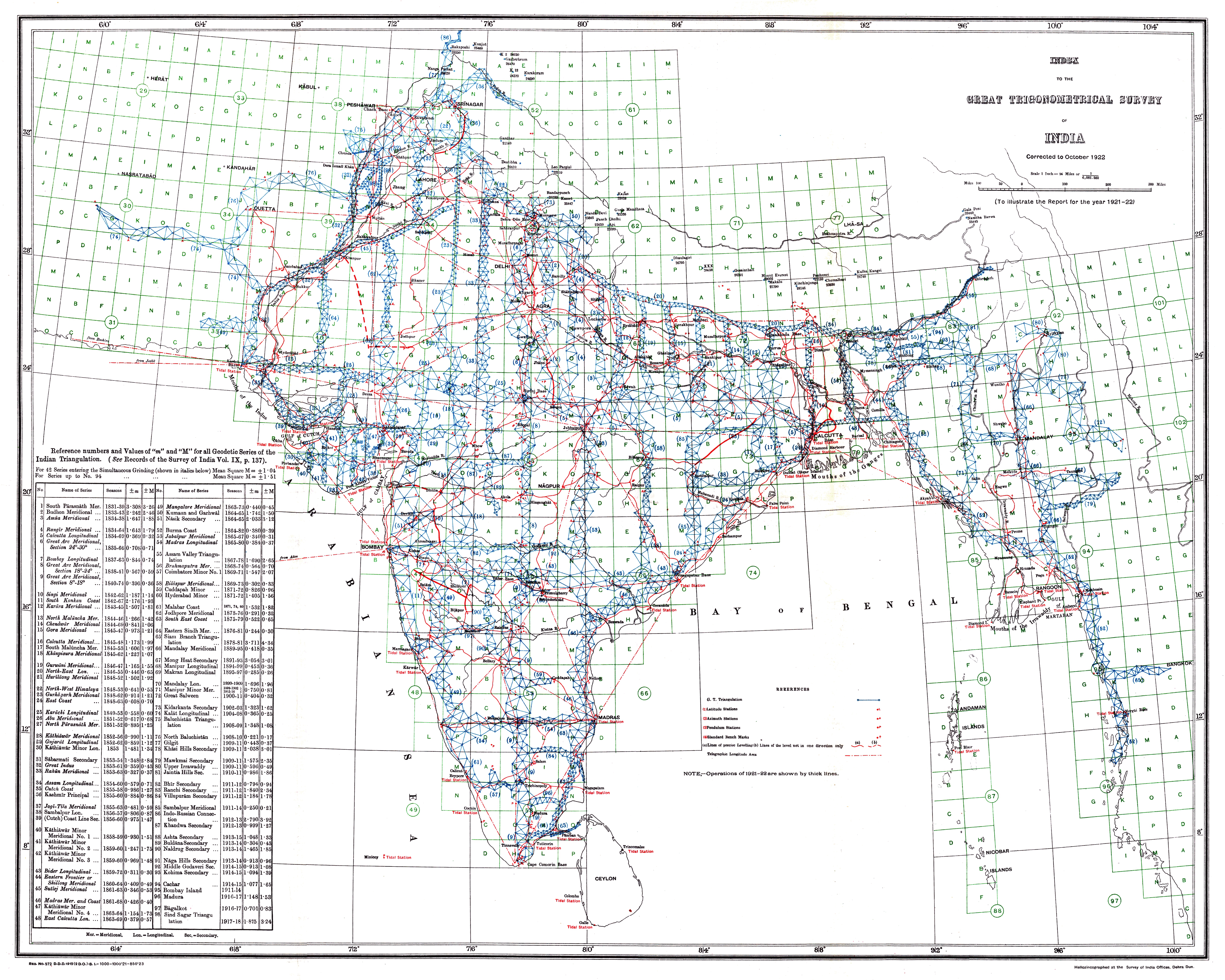
Index to the Great Trigonometrical Survey of India (1922). India is shown on a 1-degree grid of green lines. The blue triangles indicate the Great Trigonometrical w:triangulation measurements. Triangulation series are indicated by a number in parentheses. These series are described in the table at the bottom left. The red dash-dot lines are telegraph longitude area. Among the many accomplishments of the Survey were the demarcation of the British territories in India and the measurement of the height of the Himalayan giants: Everest, K2, and Kanchenjunga. |
|||||||||
| 날짜 | ||||||||||
| 출처 | Report of the Survey of India for 1921–22 | |||||||||
| 창작자 |
Survey of India, Government of India |
|||||||||
| 지리 정보 | ||||||||||
| 영역 상자 |
|
|||||||||
| 지리 참고 | ||||||||||
라이선스
This work is in the public domain in India because its term of copyright has expired.
The Indian Copyright Act applies in India to works first published in India. According to the Indian Copyright Act, 1957, as amended up to Act No. 27 of 2012 (Chapter V, Section 25):
|
 |
이 작품은 1929년 1월 1일 이전에 출판하였으므로 미국에서 퍼블릭 도메인입니다.
퍼블릭 도메인 작품을 공용에 올리기 위해서는 미국과 작품의 제작 국가에서 저작권이 만료되어야 합니다. 미국에서 제작된 작품이 아닐 경우, 제작 국가에서의 저작권 상태를 나타내는 저작권 태그를 반드시 추가로 부착해야 합니다.
|
수상
|
파일 역사
날짜/시간 링크를 클릭하면 해당 시간의 파일을 볼 수 있습니다.
| 날짜/시간 | 섬네일 | 크기 | 사용자 | 설명 | |
|---|---|---|---|---|---|
| 현재 | 2013년 9월 26일 (목) 17:59 | | 5,560 × 4,448 (16.54 MB) | Shyamal | {{Information |Description=Index to the Great Trigonometrical Survey of India (1922) |Source=Report of the Survey of India for 1921-22 |Date=1922 |Author=Survey of India, Government of India |Permission={{PD-1923}} |other_versions= }} [[Category:Maps... |
이 파일을 사용하는 문서
다음 문서 1개가 이 파일을 사용하고 있습니다:
이 파일을 사용하고 있는 모든 위키의 문서 목록
다음 위키에서 이 파일을 사용하고 있습니다:
- en.wikipedia.org에서 이 파일을 사용하고 있는 문서 목록
- Great Trigonometrical Survey
- Wikipedia:Featured pictures/Diagrams, drawings, and maps/Maps
- Wikipedia:WikiProject India/Recognized content
- Wikipedia:WikiProject India/Main page featured content
- Portal:India/Recognized content
- Wikipedia:Featured picture candidates/File:1922 Index of Great Trigonometrical Survey of India.jpg
- Wikipedia:Featured picture candidates/March-2022
- Wikipedia:Featured pictures thumbs/73
- User talk:Ixtal/Archives/2022/March
- Wikipedia:Wikipedia Signpost/2022-04-24/Featured content
- Wikipedia:Wikipedia Signpost/Single/2022-04-24
- Template:POTD/2025-08-15
- Wikipedia:Picture of the day/August 2025
- User:Ixtal/Contributions
- fr.wikipedia.org에서 이 파일을 사용하고 있는 문서 목록
- kn.wikipedia.org에서 이 파일을 사용하고 있는 문서 목록
- mr.wikipedia.org에서 이 파일을 사용하고 있는 문서 목록
- sh.wikipedia.org에서 이 파일을 사용하고 있는 문서 목록
- ta.wikipedia.org에서 이 파일을 사용하고 있는 문서 목록