
파일:1776 Rennell - Dury Wall Map of Bihar and Bengal, India - Geographicus - BaharBengal-dury-1776.jpg

미리 보기 크기: 800 × 527 픽셀 다른 해상도: 320 × 211 픽셀 | 640 × 422 픽셀 | 1,024 × 675 픽셀 | 1,280 × 843 픽셀 | 2,560 × 1,687 픽셀 | 9,106 × 6,000 픽셀
원본 파일 (9,106 × 6,000 픽셀, 파일 크기: 16.86 MB, MIME 종류: image/jpeg)
파일 설명
| 주의 | 이 그림은 크기가 상당히 크며, 일부 브라우저의 경우 그림을 실제 크기로 표시할 때 프로그램이 멈출 수 있습니다. 이 경우, '최대 해상도' 링크 위에서 마우스 오른쪽 버튼을 눌러서 컴퓨터 파일로 저장한 다음, 포토샵이나 GIMP 같은 편집기를 이용해서 파일을 열어 주세요. |
|---|
| 제목 |
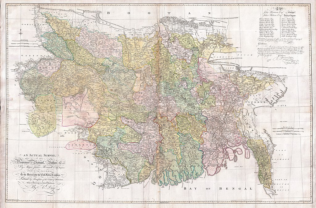
An Actual Survey, of the Provinces of Bengal, Bahar & c. by Major James Rennell Esq. Engineer to the Honorable the East India Company. Published by Permission of the Court of Directors from a Drawing in their Possession by A. Dury. |
|||||||||
| 묘사 |
English: An altogether spectacular wall sized map of those parts of Bengal and Bihar, India. Follows the course of the Ganges River from Varanasi (Benares) eastward to the Ganges Delta and the Bay of Bengal. Includes Varanasi (Benares), Dacca (Dahka, Bengladesh), and Patna among many other important Indian cities. Bounded on the north by the Himalaya Mountains and the border with Bhutan. One of the first accurate maps of the interior of India. Laid out from primary surveys done by James Rennell, the first modern cartographer to map the interior of India. Notes cities, markets, battlefields, fortresses, roads, rivers, offers political commentary, and features some geographical references. Elaborate title in the lower left quadrant. Upper right quadrant features a dedication and letter of thanks written by Andrew Dury, the publisher, to the board of the East India Company. This is the first edition of this rare map – 1776 – as published by Dury. Later editions were published by Sayer and Bennet and by Laurie and Whittle.
Another high quality digitisation is available at the David Rumsey Historical Map Collection: [1] This map was published by Laurie and Whittle, as mentioned in the description by Geographicus for the 1776 map, in 1794. Regions are demarcated in coloured outlines instead of filled colours. A higher quality digitisation than that of Geographicus. Contains parts that are missing at the central vertical fold in the Geographicus digitisation of the 1776 map. Viewable in online Flash viewer and downloadable in MrSID format. |
|||||||||
| 날짜 | (dated) | |||||||||
| 출처 |
The Bengal Atlas ??, Rennell, James, (1779 first edition)
|
|||||||||
| 창작자 | ||||||||||
| 지리 정보 | ||||||||||
| 영역 상자 |
|
|||||||||
| 지리 참고 | ||||||||||
| 보관 기록 자료 | ||||||||||
| 일련 번호 |
Geographicus link: BaharBengal-dury-1776 |
|||||||||
| 크기 | 높이: 39 in (99 cm); 너비: 59 in (149.8 cm) | |||||||||

|
이 사진은 가치있는 사진 조건을 만족하며, 다음 분야에서 공용에서 가장 가치있는 사진으로 여겨집니다: Old maps of Bengal from 1776 by Major James Rennell. 이 사진에 관한 토론을 여기에서 보실 수 있습니다. |
라이선스
|
이 작품은 미국, 그리고 저작권 보호 기간이 저작자 사후 100년, 또는 그 이하인 모든 국가에서 퍼블릭 도메인입니다. 이 작품은 1929년 1월 1일 이전에 출판하였으므로 미국에서 퍼블릭 도메인입니다. | |
| 이 저작물은 모든 저작인접권을 포함한 저작권법하의 규제로부터 자유로운 것으로 확인되었습니다. | |
파일 역사
날짜/시간 링크를 클릭하면 해당 시간의 파일을 볼 수 있습니다.
| 날짜/시간 | 섬네일 | 크기 | 사용자 | 설명 | |
|---|---|---|---|---|---|
| 현재 | 2011년 3월 17일 (목) 17:39 | | 9,106 × 6,000 (16.86 MB) | BotMultichill | {{subst:User:Multichill/Geographicus |link=http://www.geographicus.com/P/AntiqueMap/BaharBengal-dury-1776 |product_name=1776 Rennell - Dury Wall Map of Bihar and Bengal, India |map_title=An Actual Survey, of the Provinces of Bengal, Bahar & c. by Major Ja |
이 파일을 사용하는 문서
다음 문서 1개가 이 파일을 사용하고 있습니다:
이 파일을 사용하고 있는 모든 위키의 문서 목록
다음 위키에서 이 파일을 사용하고 있습니다:
- ar.wikipedia.org에서 이 파일을 사용하고 있는 문서 목록
- as.wikipedia.org에서 이 파일을 사용하고 있는 문서 목록
- azb.wikipedia.org에서 이 파일을 사용하고 있는 문서 목록
- bn.wikipedia.org에서 이 파일을 사용하고 있는 문서 목록
- bn.wikisource.org에서 이 파일을 사용하고 있는 문서 목록
- cs.wikipedia.org에서 이 파일을 사용하고 있는 문서 목록
- el.wikipedia.org에서 이 파일을 사용하고 있는 문서 목록
- en.wikipedia.org에서 이 파일을 사용하고 있는 문서 목록
- es.wikipedia.org에서 이 파일을 사용하고 있는 문서 목록
- fa.wikipedia.org에서 이 파일을 사용하고 있는 문서 목록
- fr.wikipedia.org에서 이 파일을 사용하고 있는 문서 목록
- hi.wikipedia.org에서 이 파일을 사용하고 있는 문서 목록
- ja.wikipedia.org에서 이 파일을 사용하고 있는 문서 목록
- ml.wikipedia.org에서 이 파일을 사용하고 있는 문서 목록
- mt.wikipedia.org에서 이 파일을 사용하고 있는 문서 목록
- ne.wikipedia.org에서 이 파일을 사용하고 있는 문서 목록
- nl.wikipedia.org에서 이 파일을 사용하고 있는 문서 목록
- pnb.wikipedia.org에서 이 파일을 사용하고 있는 문서 목록
- sa.wikipedia.org에서 이 파일을 사용하고 있는 문서 목록
이 파일의 더 많은 사용 내역을 봅니다.