
파일:Roman Empire full map.jpg

원본 파일 (1,166 × 942 픽셀, 파일 크기: 367 KB, MIME 종류: image/jpeg)
파일 설명
| 설명 |
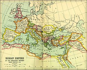
English: The Roman Empire at its greatest extent |
| 출처 |
This map of the Roman Empire was scanned from pages 16 & 17 of the 1907 Atlas of Ancient and Classical Geography in the Everyman Library, published by J.M. Dent & Sons Ltd. and is, by Canadian and US copyright law, in the public domain. It can be found for educational purposes in different universities and libraries, for instance, http://people.ucalgary.ca/~vandersp/Courses/maps/basicmap.html |
| 저자 |
라이선스
|
이 그림은 2차원 저작물에 대한 사진 복제본으로, 원본 저작물은 현재 저작권이 풀려 있는 퍼블릭 도메인 하에 있으며, 구체적인 정보는 아래와 같습니다.
위키미디어 재단에서는 2차원 저작물의 사진 복제본에 대해서 ‘2차원 퍼블릭 도메인의 사진 복제본은 역시 퍼블릭 도메인이라고 생각하며, 또한 이러한 주장은 일반적인 퍼블릭 도메인에 대한 개념으로, 이에 대한 반대는 일반적으로 사용되는 퍼블릭 도메인의 개념 자체를 반대하는 것이다’라고 입장을 밝혔습니다. 자세한 설명은 PD-Art 틀을 사용하는 경우 문서를 참조해주세요. 따라서, 이 사진 복제본은 역시 퍼블릭 도메인으로 간주됩니다. 그림을 사용할 때에는 해당 국가와 지역의 법을 확인해 주시기 바랍니다. 경우에 따라서는 관할 구역의 법에 의해 사용이 제한되어 있을 수 있습니다. 자세한 사항은 PD-Art 틀을 사용하는 경우를 확인해주세요. {{PD-Art}} template without license parameter: please specify why the underlying work is public domain in both the source country and the United States
(Usage: {{PD-Art|1=|deathyear=''year of author's death''|country=''source country''}}, where parameter 1= can be PD-old-auto, PD-old-auto-expired, PD-old-auto-1996, PD-old-100 or similar. See Commons:Multi-license copyright tags for more information.) | ||||
기존 올리기 기록
For the Common Good 도구를 사용하여 en.wikipedia에서 공용으로 옮겨왔습니다.
| 날짜/시간 | 크기 | 사용자 | 설명 |
|---|---|---|---|
| 20:24, 5 July 2010 | 1,166 × 942 (375,960 bytes) | w:en:Beao (토론 | 기여) | |
| 12:02, 23 March 2010 | 1,200 × 980 (321,311 bytes) | w:en:Aregakn (토론 | 기여) | "The roman Empire at it's greatest extent" This map of the Roman Empire was scanned from pages 16 & 17 of a 1925 reprint of the 1907 Atlas of Ancient and Classical Geography in the Everyman Library, published by J.M. Dent & Sons Ltd. and is, by Canadian |
파일 역사
날짜/시간 링크를 클릭하면 해당 시간의 파일을 볼 수 있습니다.
| 날짜/시간 | 섬네일 | 크기 | 사용자 | 설명 | |
|---|---|---|---|---|---|
| 현재 | 2015년 4월 3일 (금) 12:47 | | 1,166 × 942 (367 KB) | OgreBot | (BOT): Reverting to most recent version before archival |
| 2015년 4월 3일 (금) 12:47 |  | 1,200 × 980 (314 KB) | OgreBot | (BOT): Uploading old version of file from en.wikipedia; originally uploaded on 2010-03-23 12:02:42 by Aregakn | |
| 2015년 4월 1일 (수) 00:41 |  | 1,166 × 942 (367 KB) | Toxwiki96 | Transferred from en.wikipedia: see original upload log above |
이 파일을 사용하는 문서
다음 문서 1개가 이 파일을 사용하고 있습니다:
이 파일을 사용하고 있는 모든 위키의 문서 목록
다음 위키에서 이 파일을 사용하고 있습니다:
- en.wikipedia.org에서 이 파일을 사용하고 있는 문서 목록
- it.wikibooks.org에서 이 파일을 사용하고 있는 문서 목록