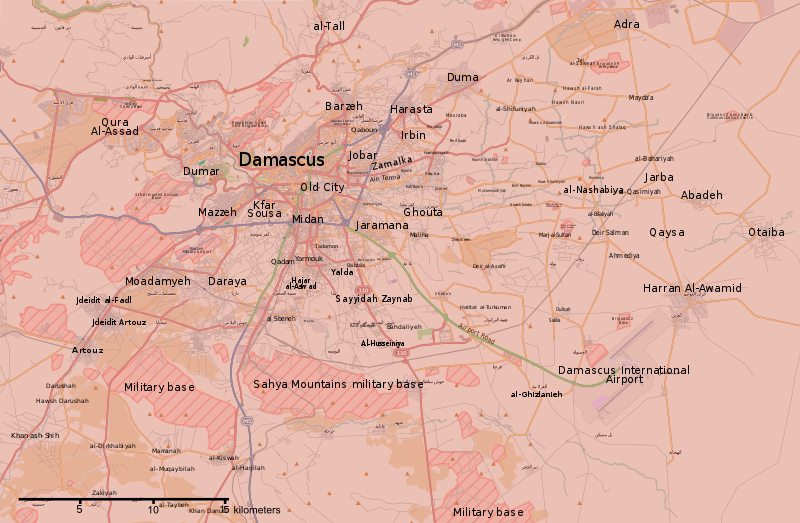
파일:Rif Damashq.svg

SVG 파일의 PNG 형식의 미리보기 크기: 800 × 523 픽셀. 다른 해상도: 320 × 209 픽셀 | 640 × 418 픽셀 | 1,024 × 670 픽셀 | 1,280 × 837 픽셀 | 2,560 × 1,674 픽셀 | 1,485 × 971 픽셀
원본 파일 (SVG 파일, 실제 크기 1,485 × 971 픽셀, 파일 크기: 7.38 MB)
파일 역사
날짜/시간 링크를 클릭하면 해당 시간의 파일을 볼 수 있습니다.
| 날짜/시간 | 섬네일 | 크기 | 사용자 | 설명 | |
|---|---|---|---|---|---|
| 현재 | 2018년 5월 22일 (화) 11:15 |  | 1,485 × 971 (7.38 MB) | Kami888 | damascus cleared |
| 2018년 5월 8일 (화) 14:56 |  | 1,485 × 971 (7.38 MB) | Kami888 | updates | |
| 2018년 5월 5일 (토) 03:00 |  | 1,485 × 971 (7.38 MB) | Kami888 | Evacuation of HTS and other non-ISIS rebels, ISIS pocket reported to be split in two. | |
| 2018년 4월 30일 (월) 03:41 |  | 1,485 × 971 (7.39 MB) | Kami888 | ISIS withdrew from Qadam http://www.syriahr.com/en/?p=90681 | |
| 2018년 4월 26일 (목) 22:34 |  | 1,485 × 971 (7.39 MB) | Kami888 | Taking update from https://pbs.twimg.com/media/Dbp4AVbX0AAxqSe.jpg:large as the only source that I know of that reports on situation in south damascus | |
| 2018년 4월 14일 (토) 11:42 |  | 1,485 × 971 (7.39 MB) | Kami888 | Army of Islam evacuated from Douma | |
| 2018년 4월 2일 (월) 08:19 |  | 1,485 × 971 (7.45 MB) | Kami888 | FAR and HTS evacuated to Idlib http://www.syriahr.com/2018/03/31/%d8%a8%d8%a7%d8%b3%d8%aa%d8%ab%d9%86%d8%a7%d8%a1-%d8%af%d9%88%d9%85%d8%a7-%d9%82%d9%88%d8%a7%d8%aa-%d8%a7%d9%84%d9%86%d8%b8%d8%a7%d9%85-%d8%aa%d9%81%d8%b1%d8%b6-%d8%b3%d9%8a%d8%b7%d8%b1%d8%aa/ | |
| 2018년 3월 27일 (화) 12:16 |  | 1,485 × 971 (7.71 MB) | Kami888 | Changed Harasta to red per suggestion on talk page. Other towns still evacuating. | |
| 2018년 3월 25일 (일) 19:43 |  | 1,485 × 971 (7.76 MB) | Kami888 | Changed Ein Terma/Hazeh. Evacuation from the other towns still appears to be ongoing. | |
| 2018년 3월 20일 (화) 21:00 |  | 1,485 × 971 (7.77 MB) | Kami888 | south Qadam to contested |
이 파일을 사용하는 문서
다음 문서 1개가 이 파일을 사용하고 있습니다:
이 파일을 사용하고 있는 모든 위키의 문서 목록
다음 위키에서 이 파일을 사용하고 있습니다:
- ar.wikipedia.org에서 이 파일을 사용하고 있는 문서 목록
- be.wikipedia.org에서 이 파일을 사용하고 있는 문서 목록
- en.wikipedia.org에서 이 파일을 사용하고 있는 문서 목록
- es.wikipedia.org에서 이 파일을 사용하고 있는 문서 목록
- fa.wikipedia.org에서 이 파일을 사용하고 있는 문서 목록
- fo.wikipedia.org에서 이 파일을 사용하고 있는 문서 목록
- hu.wikipedia.org에서 이 파일을 사용하고 있는 문서 목록
- hy.wikipedia.org에서 이 파일을 사용하고 있는 문서 목록
- id.wikipedia.org에서 이 파일을 사용하고 있는 문서 목록
- ku.wikipedia.org에서 이 파일을 사용하고 있는 문서 목록
- pa.wikipedia.org에서 이 파일을 사용하고 있는 문서 목록
- pl.wikipedia.org에서 이 파일을 사용하고 있는 문서 목록
- pt.wikipedia.org에서 이 파일을 사용하고 있는 문서 목록
- ru.wikipedia.org에서 이 파일을 사용하고 있는 문서 목록
- tr.wikipedia.org에서 이 파일을 사용하고 있는 문서 목록
- www.wikidata.org에서 이 파일을 사용하고 있는 문서 목록
- zh.wikipedia.org에서 이 파일을 사용하고 있는 문서 목록


