
파일:Paul Oct 15 2012 1815Z.jpg

미리 보기 크기: 457 × 600 픽셀 다른 해상도: 183 × 240 픽셀 | 366 × 480 픽셀 | 585 × 768 픽셀 | 780 × 1,024 픽셀 | 1,560 × 2,048 픽셀 | 6,400 × 8,400 픽셀
원본 파일 (6,400 × 8,400 픽셀, 파일 크기: 7.28 MB, MIME 종류: image/jpeg)
파일 설명
| 설명 |
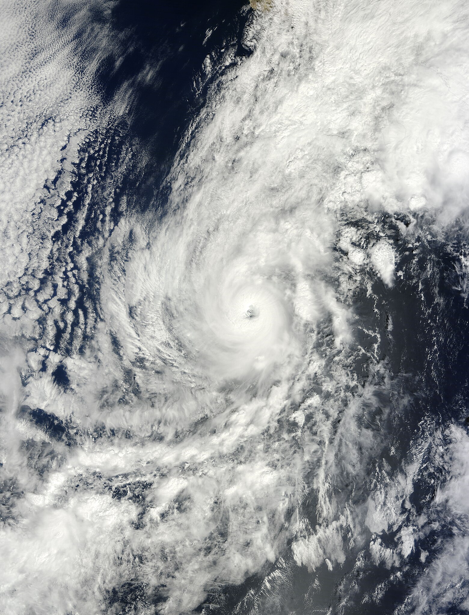
English: Paul formed as a tropical storm over the eastern Pacific Ocean on October 13, 2012. By October 15, when the Moderate Resolution Imaging Spectroradiometer (MODIS) on NASA’s Terra satellite captured this natural-color image, Paul was a hurricane bearing down on Baja California.
At roughly the same time that MODIS captured this image, the U.S. National Hurricane Center (NHC) reported that Paul had maximum sustained winds of 90 miles (150 kilometers) per hour. At 11:00 a.m. Pacific Daylight Time on October 16, Paul’s wind speeds were the same, and the center of the storm was located about 45 miles (70 kilometers) south of Cabo San Lazaro. The NHC reported that Paul was moving northwards at about 18 miles (28 kilometers) per hour, and was expected to make landfall within a few hours. The NHC warned of strong winds, heavy rains, and a dangerous storm surge for parts of Baja. |
| 날짜 | |
| 출처 | https://lance.modaps.eosdis.nasa.gov/cgi-bin/imagery/single.cgi?image=Paul.A2012289.1815.2km.jpg |
| 저자 | NASA image courtesy Jeff Schmaltz, LANCE MODIS Rapid Response Team at NASA GSFC. Caption by Michon Scott. |
| 저작권 (이 파일을 인용하기) |
Public Domain |
라이선스
| 이 파일은 NASA에서 제작하였으므로 퍼블릭 도메인입니다. NASA의 저작권 정책에 따르면 NASA의 자료는 명시하지 않는 이상 저작권의 보호를 받지 않습니다. (Template:PD-USGov, 또는 NASA 저작권 정책 문서, JPL 그림 사용 정책을 참고하세요.) | ||
 |
주의사항:
|
파일 역사
날짜/시간 링크를 클릭하면 해당 시간의 파일을 볼 수 있습니다.
| 날짜/시간 | 섬네일 | 크기 | 사용자 | 설명 | |
|---|---|---|---|---|---|
| 현재 | 2023년 8월 25일 (금) 21:36 | | 6,400 × 8,400 (7.28 MB) | Nino Marakot | Original image |
| 2012년 10월 17일 (수) 14:05 |  | 6,053 × 8,234 (13.13 MB) | Earth100 | Best version | |
| 2012년 10월 16일 (화) 14:24 |  | 6,000 × 8,366 (6.19 MB) | Earth100 | User created page with UploadWizard |
이 파일을 사용하는 문서
다음 문서 1개가 이 파일을 사용하고 있습니다:
이 파일을 사용하고 있는 모든 위키의 문서 목록
다음 위키에서 이 파일을 사용하고 있습니다:
- de.wikipedia.org에서 이 파일을 사용하고 있는 문서 목록
- en.wikipedia.org에서 이 파일을 사용하고 있는 문서 목록
- es.wikipedia.org에서 이 파일을 사용하고 있는 문서 목록
- fr.wikipedia.org에서 이 파일을 사용하고 있는 문서 목록
- pt.wikipedia.org에서 이 파일을 사용하고 있는 문서 목록
- zh.wikipedia.org에서 이 파일을 사용하고 있는 문서 목록