
파일:Warning sign in cologne.jpg

미리 보기 크기: 771 × 600 픽셀 다른 해상도: 309 × 240 픽셀 | 617 × 480 픽셀 | 987 × 768 픽셀 | 1,280 × 996 픽셀 | 2,119 × 1,649 픽셀
원본 파일 (2,119 × 1,649 픽셀, 파일 크기: 920 KB, MIME 종류: image/jpeg)
|

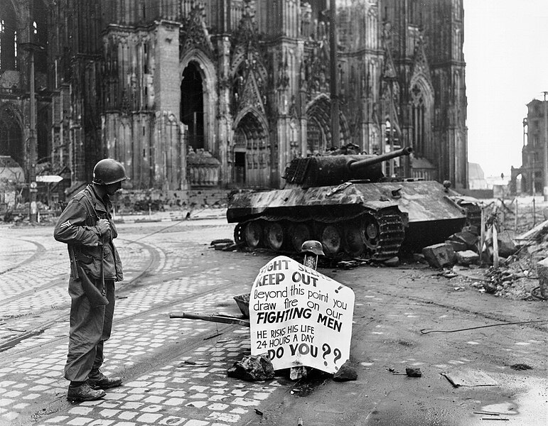
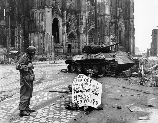
이 이미지는 2006년 5월 30일의 오늘의 이미지로 선정되었습니다. 이미지 설명은 다음과 같습니다. English: A Cpl. of 82nd Airborne Division reads a warning sign in the street Cologne, Germany, 4 April 1945. 다른 언어들:
Bahasa Melayu: Seorang Korporal dari 82nd Airborne Division membaca sebuah tanda amaran di jalan Cologne, Jerman, 4 April 1945. Català: Un soldat americá mira un cartell davant la catedral de Colonia Čeština: Voják čtoucí varování, Kolín nad Rýnem, Německo, 4. dubna 1945 Cymraeg: Milwr Americanaidd yn darllen arwydd o rybudd o yng Nghwlen (Cologne), yr Almaen, 4ydd o Ebrill 1945. Dansk: En amerikansk korporal i 82nd Airborne Division læsende et advarselsskilt i Köln, 4. april 1945. Deutsch: Ein Korporal der 82nd Airborne Division der U.S. Armee liest ein Warnschild auf der Straße; Köln, Deutschland, 4. April 1945. English: A Cpl. of 82nd Airborne Division reads a warning sign in the street Cologne, Germany, 4 April 1945. Español: Un soldado americano lee un cartel ante la catedral de Colonia Français : Un caporal de la U.S. 82nd Airborne Division (82e division aéroportée américaine) lisant un avertissement dans une rue de Cologne, Allemagne, le 4 avril 1945 Galego: Un cabo da 82 División Aerotransportada le un aviso nunha rúa de Colonia, Alemaña, 4 de abril de 1945. Lëtzebuergesch: E Kaperol vun der 82nd Airborne Division vun der U.S. Arméi liest e Warnschëld op enger Strooss zu Köln, Däitschland, 4. Abrëll 1945. Polski: Kapral 82 dywizji powietrzno-desantowej czyta napis ostrzegawczy na ulicy Kolonii. Niemcy, 4 kwietnia 1945. Português: Um soldado americano lendo um cartaz diante da catedral de Colônia, Alemanha em 4 de abril de 1945. Suomi: Alikersantti 82. maahanlaskudivisioonasta, tunnettu myös nimellä "All-Americas", lukee varoituskylttiä Kölnissä, Saksassa, 4. huhtikuuta 1945 Svenska: En amerikansk soldat läser en varningsskylt på en gata i Köln den 4 april 1945. العربية : كولن، ألمانيا، 4 أبريل 1945. |
This image was selected as picture of the day on Vietnamese Wikipedia.
|
파일 설명
| 설명 |
English: Original caption: Cologne, Germany - Cpl. Luther E. Boger, Concord, N.C., skytrooper, reads a warning sign in the street. This street leads to the Rhine River and is under observation of the Germans who occupy a stronghold there. Cpl. Boger is with the 82nd Airborne Division. 4 April 1945. The German tank is burnt out and the torsion-bars have been destroyed by the immense heat of the fire.
|
| 날짜 | 촬영 날짜: 1945년 4월 4일 |
| 출처 | US-Army history images (jpeg) |
| 저자 | Post processing by User:W.wolny |
| 다른 버전 |
.jpg)
| 카메라 위치 | | 이 지역의 다른 사진을 보기: OpenStreetMap |
|---|
라이선스
|
|
 |
파일 역사
날짜/시간 링크를 클릭하면 해당 시간의 파일을 볼 수 있습니다.
| 날짜/시간 | 섬네일 | 크기 | 사용자 | 설명 | |
|---|---|---|---|---|---|
| 현재 | 2005년 4월 20일 (수) 20:16 | | 2,119 × 1,649 (920 KB) | W.wolny |
이 파일을 사용하는 문서
다음 문서 2개가 이 파일을 사용하고 있습니다:
이 파일을 사용하고 있는 모든 위키의 문서 목록
다음 위키에서 이 파일을 사용하고 있습니다:
- ar.wikipedia.org에서 이 파일을 사용하고 있는 문서 목록
- az.wikipedia.org에서 이 파일을 사용하고 있는 문서 목록
- bg.wikipedia.org에서 이 파일을 사용하고 있는 문서 목록
- ca.wikipedia.org에서 이 파일을 사용하고 있는 문서 목록
- cs.wikipedia.org에서 이 파일을 사용하고 있는 문서 목록
- da.wikipedia.org에서 이 파일을 사용하고 있는 문서 목록
- de.wikipedia.org에서 이 파일을 사용하고 있는 문서 목록
- de.wiktionary.org에서 이 파일을 사용하고 있는 문서 목록
- el.wikipedia.org에서 이 파일을 사용하고 있는 문서 목록
- en.wikipedia.org에서 이 파일을 사용하고 있는 문서 목록
- es.wikipedia.org에서 이 파일을 사용하고 있는 문서 목록
- eu.wikipedia.org에서 이 파일을 사용하고 있는 문서 목록
- fi.wikipedia.org에서 이 파일을 사용하고 있는 문서 목록
- fr.wikipedia.org에서 이 파일을 사용하고 있는 문서 목록
- fy.wikipedia.org에서 이 파일을 사용하고 있는 문서 목록
- he.wikipedia.org에서 이 파일을 사용하고 있는 문서 목록
- hu.wikipedia.org에서 이 파일을 사용하고 있는 문서 목록
- hy.wikipedia.org에서 이 파일을 사용하고 있는 문서 목록
- hyw.wikipedia.org에서 이 파일을 사용하고 있는 문서 목록
- ia.wikipedia.org에서 이 파일을 사용하고 있는 문서 목록
- id.wikipedia.org에서 이 파일을 사용하고 있는 문서 목록
- is.wikipedia.org에서 이 파일을 사용하고 있는 문서 목록
이 파일의 더 많은 사용 내역을 봅니다.