
파일:US Navy 110320-N-OB360-166 An aerial view of ships washed ashore and overturned at a port near the Japan Air Self-Defense Force Matsushima Air Base.jpg
미리 보기 크기: 800 × 531 픽셀 다른 해상도: 320 × 212 픽셀 | 640 × 425 픽셀 | 1,024 × 680 픽셀 | 1,280 × 850 픽셀 | 2,500 × 1,660 픽셀
원본 파일 (2,500 × 1,660 픽셀, 파일 크기: 835 KB, MIME 종류: image/jpeg)
파일 설명
| 설명 |
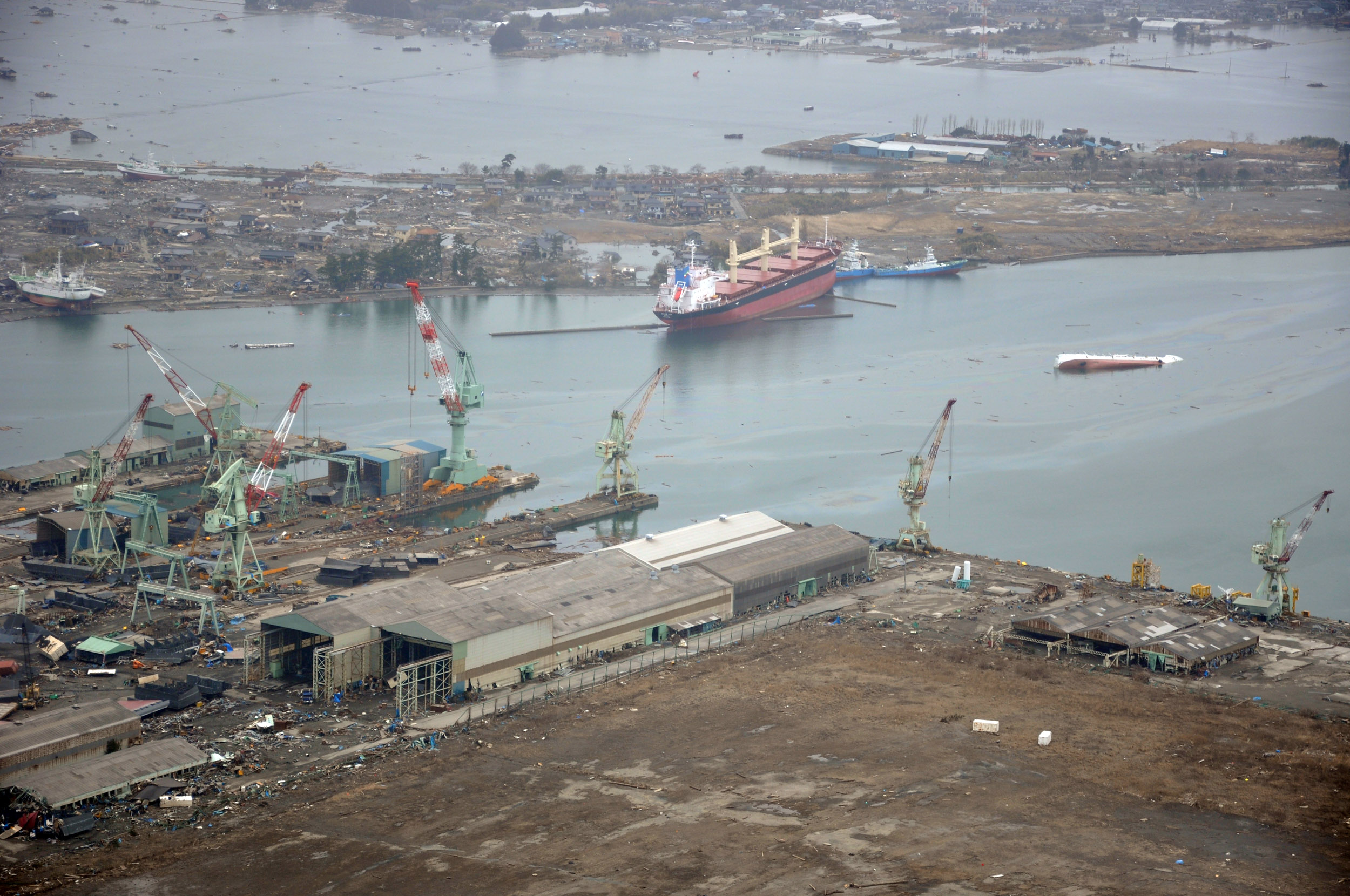
English: NORTHERN JAPAN (March 20, 2011) An aerial view of ships washed ashore and overturned at the port of Ishinomaki near the Japan Air Self-Defense Force Matsushima Air Base. The air base is serving as a refueling station for CH-46 Sea Knight helicopters assigned to Marine Medium Helicopter Squadron (HMM) 265 as they conduct humanitarian assistance missions in Northern Japan as part of Operation Tomodachi. (U.S. navy photo by Mass Communication Specialist 1st Class Ben Farone/Released)
|
|||
| 날짜 | 촬영 날짜: 2011년 3월 20일 | |||
| 출처 |
|
|||
| 저자 | U.S. navy photo by Mass Communication Specialist 1st Class Ben Farone |

| 카메라 위치 | | 이 지역의 다른 사진을 보기: OpenStreetMap |
|---|
라이선스
 | ||
| 이 저작물은 모든 저작인접권을 포함한 저작권법하의 규제로부터 자유로운 것으로 확인되었습니다. | ||
파일 역사
날짜/시간 링크를 클릭하면 해당 시간의 파일을 볼 수 있습니다.
| 날짜/시간 | 섬네일 | 크기 | 사용자 | 설명 | |
|---|---|---|---|---|---|
| 현재 | 2011년 3월 22일 (화) 11:14 | | 2,500 × 1,660 (835 KB) | BotMultichillT | == {{int:filedesc}} == {{Information |description={{en|1=NORTHERN JAPAN (March 20, 2011) An aerial view of ships washed ashore and overturned at a port near the Japan Air Self-Defense Force Matsushima Air Base. The air base is serving as a refueling stat |
이 파일을 사용하는 문서
다음 문서 1개가 이 파일을 사용하고 있습니다:
이 파일을 사용하고 있는 모든 위키의 문서 목록
다음 위키에서 이 파일을 사용하고 있습니다:
- de.wikipedia.org에서 이 파일을 사용하고 있는 문서 목록
- en.wikipedia.org에서 이 파일을 사용하고 있는 문서 목록
- fr.wikipedia.org에서 이 파일을 사용하고 있는 문서 목록
- ja.wikipedia.org에서 이 파일을 사용하고 있는 문서 목록
- ms.wikipedia.org에서 이 파일을 사용하고 있는 문서 목록
- nl.wikipedia.org에서 이 파일을 사용하고 있는 문서 목록
- tl.wikipedia.org에서 이 파일을 사용하고 있는 문서 목록
- tr.wikipedia.org에서 이 파일을 사용하고 있는 문서 목록
- zh.wikipedia.org에서 이 파일을 사용하고 있는 문서 목록