
파일:TsunamiAftermathNorthofPhuket NASA.jpg

미리 보기 크기: 647 × 599 픽셀 다른 해상도: 259 × 240 픽셀 | 518 × 480 픽셀 | 829 × 768 픽셀 | 1,106 × 1,024 픽셀 | 1,987 × 1,840 픽셀
원본 파일 (1,987 × 1,840 픽셀, 파일 크기: 720 KB, MIME 종류: image/jpeg)
파일 설명
| 설명 |
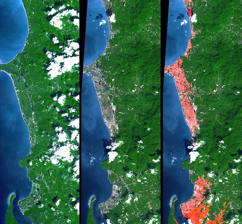
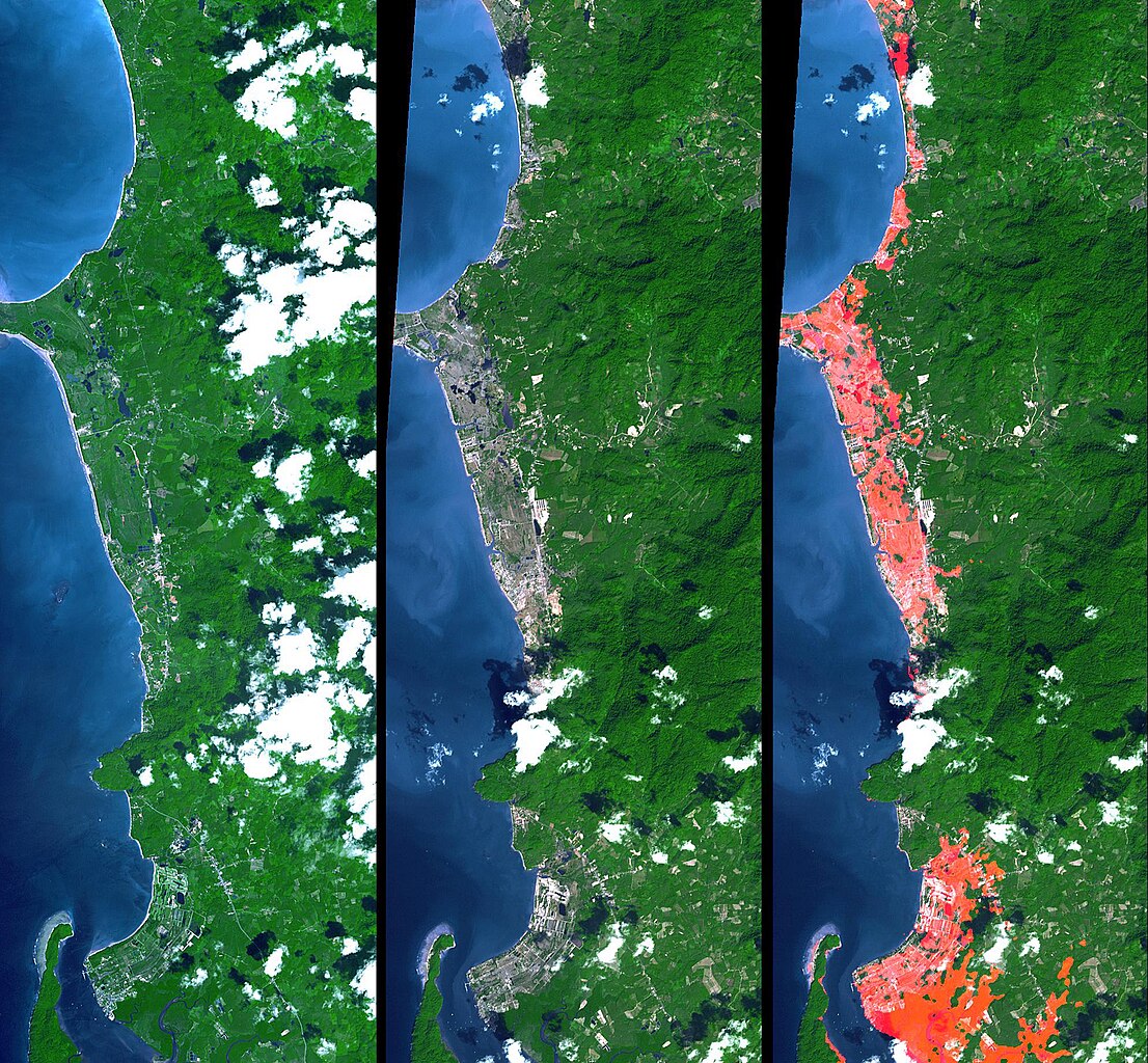
English: Simulated natural color images of a 27 kilometer long stretch of coast north of the Phuket Airport in the Khao Lak, Thailand on December 31 (middle) and two years earlier (left), showing changes to the coast caused by a tsunami. The image on the right is the image in the middle with red highlights of the changes. Additional details can be found at the source link. |
| 날짜 | November 15, 2002 and December 31, 2004 (ASTER), February 2000 (SRTM). See the source link for information about the individual photos |
| 출처 | NASA Photojournal - http://photojournal.jpl.nasa.gov/catalog/PIA06671 |
| 저자 |
ASTER: NASA/GSFC/METI/ERSDAC/JAROS, and U.S./Japan ASTER Science Team |
라이선스
| 이 파일은 NASA에서 제작하였으므로 퍼블릭 도메인입니다. NASA의 저작권 정책에 따르면 NASA의 자료는 명시하지 않는 이상 저작권의 보호를 받지 않습니다. (Template:PD-USGov, 또는 NASA 저작권 정책 문서, JPL 그림 사용 정책을 참고하세요.) | ||
 |
주의사항:
|
기존 올리기 기록
The original description page was here. All following user names refer to en.wikipedia.
- 2005-04-16 17:22 SeanMack 1987×1840× (737390 bytes) PIA06671: Tsunami Inundation, North of Phuket, Thailand ASTER Images and SRTM Elevation Model NASA
파일 역사
날짜/시간 링크를 클릭하면 해당 시간의 파일을 볼 수 있습니다.
| 날짜/시간 | 섬네일 | 크기 | 사용자 | 설명 | |
|---|---|---|---|---|---|
| 현재 | 2012년 1월 2일 (월) 10:43 | | 1,987 × 1,840 (720 KB) | File Upload Bot (Magnus Manske) | {{BotMoveToCommons|en.wikipedia|year={{subst:CURRENTYEAR}}|month={{subst:CURRENTMONTHNAME}}|day={{subst:CURRENTDAY}}}} {{Information |Description={{en|PIA06671: Tsunami Inundation, North of Phuket, Thailand ASTER Images and SRTM Elevation Model Source: |
이 파일을 사용하는 문서
다음 문서 1개가 이 파일을 사용하고 있습니다:
이 파일을 사용하고 있는 모든 위키의 문서 목록
다음 위키에서 이 파일을 사용하고 있습니다:
- de.wikipedia.org에서 이 파일을 사용하고 있는 문서 목록
- el.wikipedia.org에서 이 파일을 사용하고 있는 문서 목록
- en.wikipedia.org에서 이 파일을 사용하고 있는 문서 목록
- eo.wikipedia.org에서 이 파일을 사용하고 있는 문서 목록
- ms.wikipedia.org에서 이 파일을 사용하고 있는 문서 목록
- my.wikipedia.org에서 이 파일을 사용하고 있는 문서 목록
- pt.wikipedia.org에서 이 파일을 사용하고 있는 문서 목록
- tr.wikipedia.org에서 이 파일을 사용하고 있는 문서 목록
- www.wikidata.org에서 이 파일을 사용하고 있는 문서 목록