
파일:The Burning of Cork (9713428703).jpg

원본 파일 (1,978 × 1,420 픽셀, 파일 크기: 1.06 MB, MIME 종류: image/jpeg)
파일 설명
| 설명 |
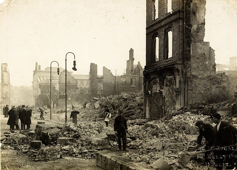
St Patrick's Street in Cork, Ireland on (or around) 14 December 1920. The image captures the aftermath of what's known as en:the Burning of Cork. This event occurred on 11-12 December 1920 during the Irish War of Independence. The primary subject are destroyed buildings in the area from Cook Street to Robert street to Winthrop Street (off Patrick street)in Cork. To the right foreground are workers in clean-up efforts. The prominent building facade (right/middle-ground) has visible stonework signage which reads: Pharmaceutical & Dispensing Chemist. This building was Sunner's chemist shop, #31 Patrick Street. Immediately to its left (behind the arched lamps) was where #29/30 Patrick Street stood. This was the Munster Arcade. Photographer: W.D. Hogan Date: Circa Tuesday, 14 December 1920. NLI Ref.: HOGW 153 |
| 출처 |
|
| 저자 | National Library of Ireland on The Commons |
| 저작권 (이 파일을 인용하기) |
National Library of Ireland on The Commons @ Flickr Commons |
| 다른 버전 |

.jpg?uselang=ko)
| 카메라 위치 | | 이 지역의 다른 사진을 보기: OpenStreetMap |
|---|
.jpg¶ms=051.898450_N_-008.471950_E_globe:Earth_type:camera_source:Flickr_&language=ko)
라이선스
This image was taken from Flickr's The Commons. The uploading organization may have various reasons for determining that no known copyright restrictions exist, such as:
More information can be found at https://flickr.com/commons/usage/. Please add additional copyright tags to this image if more specific information about copyright status can be determined. See Commons:Licensing for more information. |
| 플리커에 게시된 이 그림은 2013년 9월 11일에 관리자 혹은 신뢰된 사용자 File Upload Bot (Magnus Manske)에 의해 검토되어, 이 날짜를 기준으로 위의 라이선스로 사용 가능함이 확인되었습니다. |
파일 역사
날짜/시간 링크를 클릭하면 해당 시간의 파일을 볼 수 있습니다.
| 날짜/시간 | 섬네일 | 크기 | 사용자 | 설명 | |
|---|---|---|---|---|---|
| 현재 | 2019년 12월 8일 (일) 04:39 | | 1,978 × 1,420 (1.06 MB) | Holly Cheng | Cropped 1 % horizontally, 1 % vertically using CropTool with precise mode. |
| 2013년 9월 12일 (목) 00:59 |  | 2,000 × 1,431 (1.03 MB) | File Upload Bot (Magnus Manske) | Transferred from Flickr by User:guliolopez |
이 파일을 사용하는 문서
다음 문서 1개가 이 파일을 사용하고 있습니다:
이 파일을 사용하고 있는 모든 위키의 문서 목록
다음 위키에서 이 파일을 사용하고 있습니다:
- az.wikipedia.org에서 이 파일을 사용하고 있는 문서 목록
- ba.wikipedia.org에서 이 파일을 사용하고 있는 문서 목록
- cs.wikipedia.org에서 이 파일을 사용하고 있는 문서 목록
- en.wikipedia.org에서 이 파일을 사용하고 있는 문서 목록
- Irish War of Independence
- Wikipedia:Selected anniversaries/December 11
- Auxiliary Division
- Timeline of the Irish War of Independence
- History of Cork
- Cork Premier Senior Hurling Championship
- Cork Premier Senior Football Championship
- Cork (city)
- Burning of Cork
- December 1920
- Wikipedia:Main Page history/2019 December 11
- Wikipedia:Main Page history/2020 December 11
- Wikipedia:Main Page history/2020 December 11b
- es.wikipedia.org에서 이 파일을 사용하고 있는 문서 목록
- fr.wikipedia.org에서 이 파일을 사용하고 있는 문서 목록
- ga.wikipedia.org에서 이 파일을 사용하고 있는 문서 목록
- he.wikipedia.org에서 이 파일을 사용하고 있는 문서 목록
- hy.wikipedia.org에서 이 파일을 사용하고 있는 문서 목록
- ja.wikipedia.org에서 이 파일을 사용하고 있는 문서 목록
- nl.wikipedia.org에서 이 파일을 사용하고 있는 문서 목록
- no.wikipedia.org에서 이 파일을 사용하고 있는 문서 목록
- pl.wikipedia.org에서 이 파일을 사용하고 있는 문서 목록
- pt.wikipedia.org에서 이 파일을 사용하고 있는 문서 목록
- ro.wikipedia.org에서 이 파일을 사용하고 있는 문서 목록
- ru.wikipedia.org에서 이 파일을 사용하고 있는 문서 목록
- vls.wikipedia.org에서 이 파일을 사용하고 있는 문서 목록
- www.wikidata.org에서 이 파일을 사용하고 있는 문서 목록
.jpg)