
파일:Tectonic plates boundaries World map Wt 180degE centered-en.svg

SVG 파일의 PNG 형식의 미리보기 크기: 800 × 489 픽셀. 다른 해상도: 320 × 196 픽셀 | 640 × 391 픽셀 | 1,024 × 626 픽셀 | 1,280 × 782 픽셀 | 2,560 × 1,564 픽셀 | 4,903 × 2,996 픽셀
원본 파일 (SVG 파일, 실제 크기 4,903 × 2,996 픽셀, 파일 크기: 4.86 MB)
파일 설명
| 설명 |
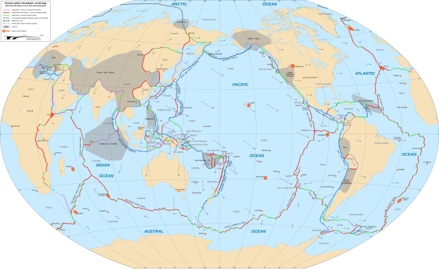
English: World map in English showing the tectonic plates boundaries with their movement vectors and selected hotspots.
Français : Carte mondiale en anglais des limites des plaques tectoniques avec leurs vecteurs de déplacement et une sélection de hotspots.
Español: Mapa en inglés que muestra las placas tectónicas con sus vectores de movimiento.
Winkel tripel projection; central longitude: 180° E |
||
| 날짜 | |||
| 출처 |
|
||
| 저자 | Eric Gaba (Sting - fr:Sting) | ||
| 저작권 (이 파일을 인용하기) |
|
||
| 다른 버전 |
[]
|


|
이 SVG 파일은 편집 가능한 문자를 사용하므로 Inkscape나 Adobe Illustrator를 사용하여 쉽게 다른 언어로 번역할 수 있습니다. 여기를 참고하세요. 또한 텍스트 편집기를 이용하여 수동으로 파일을 번역할 수도 있습니다. |
라이선스
이 파일은 크리에이티브 커먼즈 저작자표시-동일조건변경허락 3.0 Unported 라이선스로 배포됩니다.
저작자표시: "Eric Gaba for Wikimedia Commons"
- 이용자는 다음의 권리를 갖습니다:
- 공유 및 이용 – 저작물의 복제, 배포, 전시, 공연 및 공중송신
- 재창작 – 저작물의 개작, 수정, 2차적저작물 창작
- 다음과 같은 조건을 따라야 합니다:
- 저작자표시 – 적절한 저작자 표시를 제공하고, 라이센스에 대한 링크를 제공하고, 변경사항이 있는지를 표시해야 합니다. 당신은 합리적인 방식으로 표시할 수 있지만, 어떤 방식으로든 사용권 허가자가 당신 또는 당신의 사용을 지지하는 방식으로 표시할 수 없습니다.
- 동일조건변경허락 – 만약 당신이 이 저작물을 리믹스 또는 변형하거나 이 저작물을 기반으로 제작하는 경우, 당신은 당신의 기여물을 원저작물과 동일하거나 호환 가능한 라이선스에 따라 배포하여야 합니다.
파일 역사
날짜/시간 링크를 클릭하면 해당 시간의 파일을 볼 수 있습니다.
| 날짜/시간 | 섬네일 | 크기 | 사용자 | 설명 | |
|---|---|---|---|---|---|
| 현재 | 2018년 2월 17일 (토) 05:38 | | 4,903 × 2,996 (4.86 MB) | Sting | {{Information |Description={{en|World map in English showing the tectonic plates boundaries with their movement vectors and selected hotspots.}} {{fr|Carte mondiale en anglais des limites des plaques tectoniques avec leurs vecteurs de déplacement et u... |
이 파일을 사용하는 문서
다음 문서 1개가 이 파일을 사용하고 있습니다:
이 파일을 사용하고 있는 모든 위키의 문서 목록
다음 위키에서 이 파일을 사용하고 있습니다:
- bn.wikipedia.org에서 이 파일을 사용하고 있는 문서 목록
- el.wikipedia.org에서 이 파일을 사용하고 있는 문서 목록
- en.wikipedia.org에서 이 파일을 사용하고 있는 문서 목록
- Plate tectonics
- Mid-Atlantic Ridge
- Subduction
- Galápagos Islands
- Gakkel Ridge
- Pacific-Antarctic Ridge
- Eurasian Plate
- North American Plate
- Juan de Fuca Plate
- List of tectonic plates
- Farallon Plate
- South American Plate
- Gorda Plate
- Nazca Plate
- Antarctic Plate
- Pacific Plate
- Cocos Plate
- Philippine Sea Plate
- African Plate
- Arabian Plate
- Indo-Australian Plate
- Explorer Plate
- Anatolian Sub-Plate
- Australian Plate
- Abyssal plain
- Hotspot (geology)
- Mountain formation
- East Pacific Rise
- Burma Plate
- Indian Plate
- Scotia Plate
- Caribbean Plate
- Okhotsk microplate
- Amurian microplate
- Kerguelen Plateau
이 파일의 더 많은 사용 내역을 봅니다.