
파일:September 17 2001.jpg
미리 보기 크기: 750 × 600 픽셀 다른 해상도: 300 × 240 픽셀 | 600 × 480 픽셀 | 960 × 768 픽셀 | 1,280 × 1,024 픽셀 | 2,560 × 2,048 픽셀 | 3,000 × 2,400 픽셀
원본 파일 (3,000 × 2,400 픽셀, 파일 크기: 2.89 MB, MIME 종류: image/jpeg)
| 설명 |
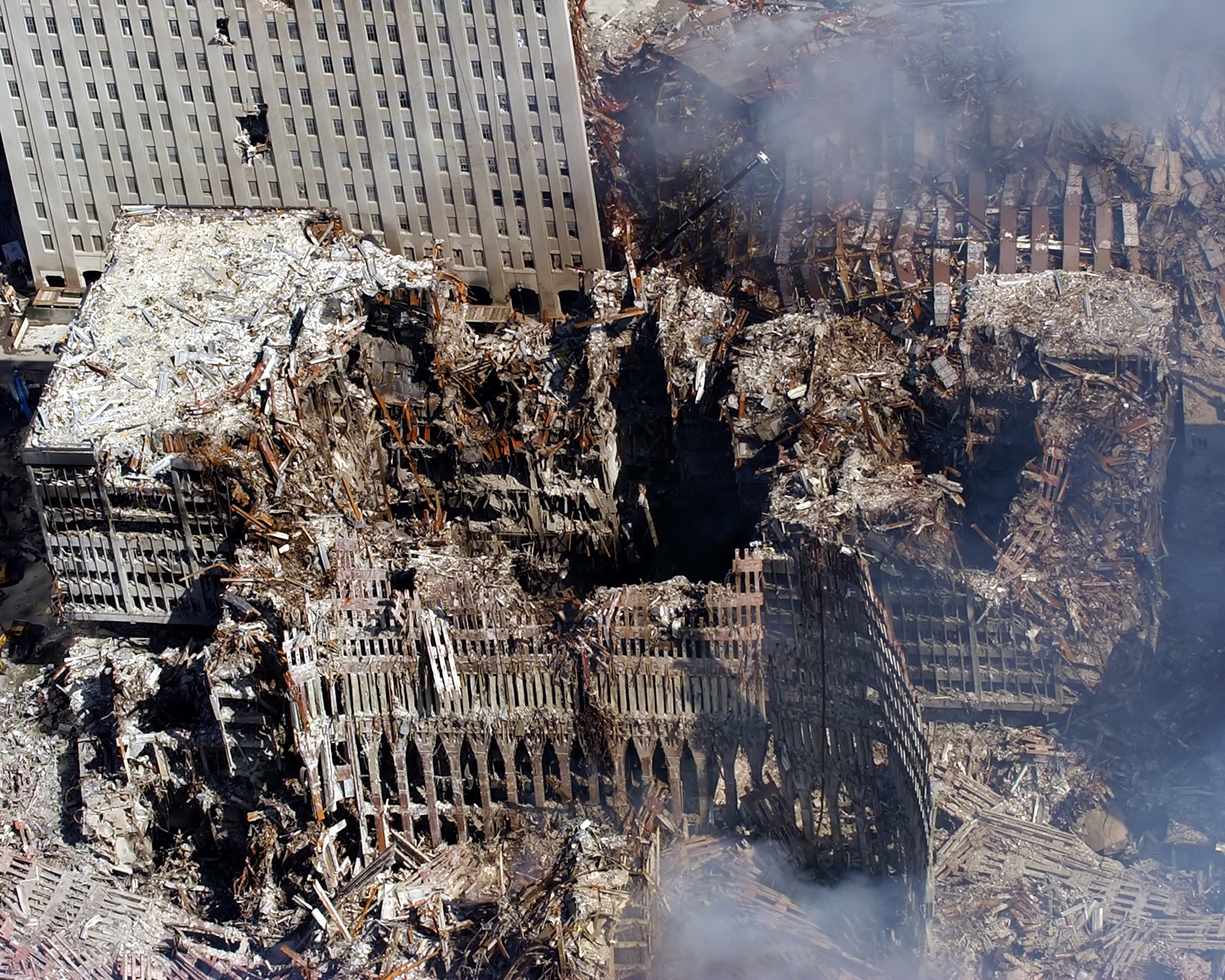
English: Ground Zero, New York City, N.Y. (Sept. 17, 2001) -- An aerial view shows only a small portion of the crime scene where the World Trade Center collapsed following the Sept. 11 terrorist attack. Surrounding buildings were heavily damaged by the debris and massive force of the falling twin towers. Clean-up efforts are expected to continue for months. U.S. Navy photo by Chief Photographer's Mate Eric J. Tilford. (RELEASED) |
||||||
| 날짜 | |||||||
| 출처 |
|
||||||
| 저자 | U.S. Navy photo by Chief Photographer's Mate Eric J. Tilford. | ||||||
| 저작권 (이 파일을 인용하기) |
|
||||||
| 다른 버전 | File:US Navy 010917-N-7479T-515 An aerial view shows only a small portion of the crime scene where the World Trade Center collapsed following the Sept. 11 terrorist attack.jpg | ||||||


파일 역사
날짜/시간 링크를 클릭하면 해당 시간의 파일을 볼 수 있습니다.
| 날짜/시간 | 섬네일 | 크기 | 사용자 | 설명 | |
|---|---|---|---|---|---|
| 현재 | 2007년 2월 9일 (금) 09:32 | | 3,000 × 2,400 (2.89 MB) | Zarex | reduced some noise and slightly sharpened |
| 2005년 6월 2일 (목) 06:23 |  | 3,000 × 2,400 (2.97 MB) | Quasipalm | Ground Zero, New York City, N.Y. (Sept. 17, 2001) -- An aerial view shows only a small portion of the crime scene where the World Trade Center collapsed following the Sept. 11 terrorist attack. Surrounding buildings were heavily damaged by the debris and | |
| 2005년 6월 2일 (목) 06:23 |  | 2,400 × 3,000 (2.75 MB) | Quasipalm | Ground Zero, New York City, N.Y. (Sept. 17, 2001) -- An aerial view shows only a small portion of the crime scene where the World Trade Center collapsed following the Sept. 11 terrorist attack. Surrounding buildings were heavily damaged by the debris and | |
| 2005년 6월 2일 (목) 06:23 |  | 2,400 × 3,000 (2.18 MB) | Quasipalm | Ground Zero, New York City, N.Y. (Sept. 17, 2001) -- An aerial view shows only a small portion of the crime scene where the World Trade Center collapsed following the Sept. 11 terrorist attack. Surrounding buildings were heavily damaged by the debris and | |
| 2005년 6월 2일 (목) 06:23 |  | 3,000 × 2,400 (2.82 MB) | Quasipalm | Ground Zero, New York City, N.Y. (Sept. 17, 2001) -- An aerial view shows only a small portion of the crime scene where the World Trade Center collapsed following the Sept. 11 terrorist attack. Surrounding buildings were heavily damaged by the debris and | |
| 2005년 6월 2일 (목) 06:23 |  | 2,400 × 3,000 (2.87 MB) | Quasipalm | Ground Zero, New York City, N.Y. (Sept. 17, 2001) -- An aerial view shows only a small portion of the crime scene where the World Trade Center collapsed following the Sept. 11 terrorist attack. Surrounding buildings were heavily damaged by the debris and |
이 파일을 사용하는 문서
다음 문서 1개가 이 파일을 사용하고 있습니다:
이 파일을 사용하고 있는 모든 위키의 문서 목록
다음 위키에서 이 파일을 사용하고 있습니다:
- ar.wikipedia.org에서 이 파일을 사용하고 있는 문서 목록
- ast.wikipedia.org에서 이 파일을 사용하고 있는 문서 목록
- bn.wikipedia.org에서 이 파일을 사용하고 있는 문서 목록
- ca.wikipedia.org에서 이 파일을 사용하고 있는 문서 목록
- da.wikipedia.org에서 이 파일을 사용하고 있는 문서 목록
- el.wikipedia.org에서 이 파일을 사용하고 있는 문서 목록
- en.wikipedia.org에서 이 파일을 사용하고 있는 문서 목록
- en.wikiquote.org에서 이 파일을 사용하고 있는 문서 목록
- es.wikipedia.org에서 이 파일을 사용하고 있는 문서 목록
- fa.wikipedia.org에서 이 파일을 사용하고 있는 문서 목록
- fr.wikipedia.org에서 이 파일을 사용하고 있는 문서 목록
- gl.wikipedia.org에서 이 파일을 사용하고 있는 문서 목록
- he.wikipedia.org에서 이 파일을 사용하고 있는 문서 목록
- hi.wikipedia.org에서 이 파일을 사용하고 있는 문서 목록
- hu.wikipedia.org에서 이 파일을 사용하고 있는 문서 목록
- hy.wikipedia.org에서 이 파일을 사용하고 있는 문서 목록
- ms.wikipedia.org에서 이 파일을 사용하고 있는 문서 목록
- my.wikipedia.org에서 이 파일을 사용하고 있는 문서 목록
- pt.wikipedia.org에서 이 파일을 사용하고 있는 문서 목록
- ru.wikipedia.org에서 이 파일을 사용하고 있는 문서 목록
- sh.wikipedia.org에서 이 파일을 사용하고 있는 문서 목록
- si.wikipedia.org에서 이 파일을 사용하고 있는 문서 목록
- sr.wikipedia.org에서 이 파일을 사용하고 있는 문서 목록
- sv.wikipedia.org에서 이 파일을 사용하고 있는 문서 목록
- sv.wikinews.org에서 이 파일을 사용하고 있는 문서 목록
- tl.wikipedia.org에서 이 파일을 사용하고 있는 문서 목록
- tr.wikipedia.org에서 이 파일을 사용하고 있는 문서 목록
- uk.wikipedia.org에서 이 파일을 사용하고 있는 문서 목록
- vi.wikipedia.org에서 이 파일을 사용하고 있는 문서 목록
이 파일의 더 많은 사용 내역을 봅니다.