파일:Sanriku-Erdbeben.jpg

문서 내용이 다른 언어로는 지원되지 않습니다.
위키백과, 우리 모두의 백과사전.

원본 파일(796 × 858 픽셀, 파일 크기: 161 KB, MIME 종류: image/jpeg)

파일 설명

설명
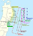
English: Historical tsunamis in the Sanriku area and selection of areas affected by the 2011 Tōhoku tsunami. (Source: Anawat Suppasri, Nobuo Shuto, Fumihiko Imamura, Shunichi Koshimura, Erick Mas, Ahmet Cevdet Yalciner: "Lessons Learned from the 2011 Great East Japan Tsunami: Performance of Tsunami Countermeasures, Coastal Buildings, and Tsunami Evacuation in Japan", Pure and Applied Geophysics, 170, (6-8), 2013, p. 993–1018, here p. 994, figure 1, DOI=10.1007/s00024-012-0511-7, online published: 7. July 2012. Modified and combined with: Nobuhito Mori, Daniel T. Cox, Tomohiro Yasuda, Hajime Mase: "Overview of the 2011 Tohoku Earthquake Tsunami Damage and Its Relation to Coastal Protection along the Sanriku Coast", Earthquake Spectra, 29 (S1), 2013, pp. 127-143, DOI=10.1193/1.4000118, here p. 131, fig. 3. And combined with: Tadashi Nakasu, Yuichi Ono, Wiraporn Pothisiri: "Why did Rikuzentakata have a high death toll in the 2011 Great East Japan Earthquake and Tsunami disaster? Finding the devastating disaster’s root causes", International Journal of Disaster Risk Reduction, Band=27, March 2018, pp. 21-36, DOI: 10.1016/j.ijdrr.2017.08.001, online published on 15 August 2017, here p. 23, fig. 1. Cf. Akemi Ishigaki, Hikari Higashi, Takako Sakamoto, Shigeki Shibahara: "The Great East-Japan Earthquake and Devastating Tsunami: An Update and Lessons from the Past Great Earthquakes in Japan since 1923", The Tohoku Journal of Experimental Medicine, 229, 4, 2013, pp. 287-299, DOI:10.1620/tjem.229.287, online published on 13 April 2013, here: p. 289, Fig. 1 "Distribution of the epicenters of the three Great Earthquakes."
Deutsch: Historische Tsunamis in der Sanriku-Region und Auswahl von Gebieten, die vom Tōhoku-Tsunami von 2011 betroffen waren. (Quelle: Anawat Suppasri, Nobuo Shuto, Fumihiko Imamura, Shunichi Koshimura, Erick Mas, Ahmet Cevdet Yalciner: "Lessons Learned from the 2011 Great East Japan Tsunami: Performance of Tsunami Countermeasures, Coastal Buildings, and Tsunami Evacuation in Japan", Pure and Applied Geophysics, 170, (6-8), 2013, S. 993–1018, hier S. 994, Abb. 1, DOI=10.1007/s00024-012-0511-7, online veröffentlicht am: 7. Juli 2012.) Verändert und kombiniert mit: Nobuhito Mori, Daniel T. Cox, Tomohiro Yasuda, Hajime Mase: "Overview of the 2011 Tohoku Earthquake Tsunami Damage and Its Relation to Coastal Protection along the Sanriku Coast", Earthquake Spectra, 29 (S1), 2013, S. 127-143, DOI=10.1193/1.4000118, hier S. 131, Abb. 3. Und kombiniert mit: Tadashi Nakasu, Yuichi Ono, Wiraporn Pothisiri: "Why did Rikuzentakata have a high death toll in the 2011 Great East Japan Earthquake and Tsunami disaster? Finding the devastating disaster’s root causes", International Journal of Disaster Risk Reduction, Band=27, März 2018, S. 21-36, DOI: 10.1016/j.ijdrr.2017.08.001, online veröffentlicht am 15. August 2017, hier S. 23, Abb. 1
날짜
출처 자작; Original for content: Anawat Suppasri, Nobuo Shuto, Fumihiko Imamura, Shunichi Koshimura, Erick Mas, Ahmet Cevdet Yalciner: "Lessons Learned from the 2011 Great East Japan Tsunami: Performance of Tsunami Countermeasures, Coastal Buildings, and Tsunami Evacuation in Japan", Pure and Applied Geophysics, 170, (6-8), 2013, p. 993–1018, DOI=10.1007/s00024-012-0511-7, online published: 7. July 2012.
저자 Modification and map: Anglo-Araneophilus~commonswiki, Original for content: Anawat Suppasri, Nobuo Shuto, Fumihiko Imamura, Shunichi Koshimura, Erick Mas, Ahmet Cevdet Yalciner: "Lessons Learned from the 2011 Great East Japan Tsunami: Performance of Tsunami Countermeasures, Coastal Buildings, and Tsunami Evacuation in Japan", Pure and Applied Geophysics, 170, (6-8), 2013, p. 993–1018, DOI=10.1007/s00024-012-0511-7, online published: 7. July 2012.
저작권
(이 파일을 인용하기)
w:ko:크리에이티브 커먼즈
저작자표시 동일조건변경허락
이용자는 다음의 권리를 갖습니다:
  • 공유 및 이용 – 저작물의 복제, 배포, 전시, 공연 및 공중송신
  • 재창작 – 저작물의 개작, 수정, 2차적저작물 창작
다음과 같은 조건을 따라야 합니다:
  • 저작자표시 – 적절한 저작자 표시를 제공하고, 라이센스에 대한 링크를 제공하고, 변경사항이 있는지를 표시해야 합니다. 당신은 합리적인 방식으로 표시할 수 있지만, 어떤 방식으로든 사용권 허가자가 당신 또는 당신의 사용을 지지하는 방식으로 표시할 수 없습니다.
  • 동일조건변경허락 – 만약 당신이 이 저작물을 리믹스 또는 변형하거나 이 저작물을 기반으로 제작하는 경우, 당신은 당신의 기여물을 원저작물과 동일하거나 호환 가능한 라이선스에 따라 배포하여야 합니다.

설명

이 파일이 나타내는 바에 대한 한 줄 설명을 추가합니다

이 파일에 묘사된 항목

다음을 묘사함

파일 역사

날짜/시간 링크를 클릭하면 해당 시간의 파일을 볼 수 있습니다.

날짜/시간섬네일크기사용자설명
현재2018년 8월 15일 (수) 04:092018년 8월 15일 (수) 04:09 판의 섬네일796 × 858 (161 KB)Anglo-Araneophilus~commonswikiModified and combined with: Anawat Suppasri,Yo Fukutani,Yoshi Abe,Fumihiko Imamura: "Relationship between earthquake magnitude and tsunami height along the Tohoku coast based on historical tsunami trace database and the 2011 Great East Japan Tsunami", Report of Tsunami Engineering, Vol. 30 (2013), pp. 37-49, here: Fig. 2 ("Location of tsunami affected areas and historical tsunami height distribution").
2018년 4월 6일 (금) 17:212018년 4월 6일 (금) 17:21 판의 섬네일796 × 858 (158 KB)Anglo-Araneophilus~commonswikiModified and combined with: Tadashi Nakasu, Yuichi Ono, Wiraporn Pothisiri: "Why did Rikuzentakata have a high death toll in the 2011 Great East Japan Earthquake and Tsunami disaster? Finding the devastating disaster’s root causes", International Journal of Disaster Risk Reduction, Band=27, March 2018, pp. 21-36, DOI: 10.1016/j.ijdrr.2017.08.001, online published on 15 August 2017.
2018년 4월 2일 (월) 04:332018년 4월 2일 (월) 04:33 판의 섬네일796 × 858 (150 KB)Anglo-Araneophilus~commonswikiModified and combined with: Nobuhito Mori, Daniel T. Cox, Tomohiro Yasuda, Hajime Mase: "Overview of the 2011 Tohoku Earthquake Tsunami Damage and Its Relation to Coastal Protection along the Sanriku Coast", Earthquake Spectra, 29 (S1), 2013, pp. 127-143, DOI=10.1193/1.4000118.
2018년 4월 1일 (일) 00:422018년 4월 1일 (일) 00:42 판의 섬네일796 × 858 (130 KB)Anglo-Araneophilus~commonswiki{{Information |description ={{en|1=Historical tsunamis in the Sanriku area and selection of areas affected by the 2011 Tōhoku tsunami. (Source: Anawat Suppasri, Nobuo Shuto, Fumihiko Imamura, Shunichi Koshimura, Erick Mas, Ahmet Cevdet Yalciner: "Lessons Learned from the 2011 Great East Japan Tsunami: Performance of Tsunami Countermeasures, Coastal Buildings, and Tsunami Evacuation in Japan", Pure and Applied Geophysics, 170, (6-8), 2013, p. 993–1018, here p. 994, figure 1, DOI=10.1007/s000...

다음 문서 3개가 이 파일을 사용하고 있습니다:

이 파일을 사용하고 있는 모든 위키의 문서 목록

다음 위키에서 이 파일을 사용하고 있습니다:

메타데이터