
파일:Premongol.png
최대 해상도입니다.
Premongol.png (752 × 590 픽셀, 파일 크기: 31 KB, MIME 종류: image/png)
파일 설명

|
This map has been uploaded by Electionworld from en.wikipedia.org to enable the |
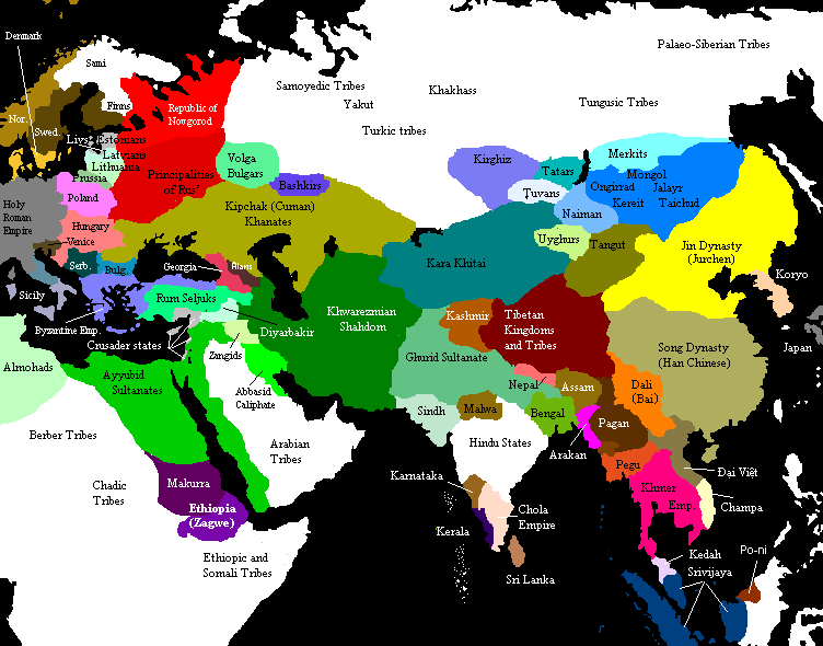
Eurasia on the eve of the Mongol invasions, c. 1200 CE. Source unknown. All of Central, North and East Asian states and tribes were located in wrong places.

|
이 그림 파일은 벡터 SVG 형식으로 다시 만들어야 합니다. SVG의 장점에 대해서는 여기(영어)를 참고해 주십시오. 만약 이 그림의 SVG 버전이 이미 존재한다면 이 틀을 {{vector version available|새 파일 이름.svg}}으로 대체해 주십시오.
|
라이선스

|
GNU 자유 문서 사용 허가서 1.2판 또는 자유 소프트웨어 재단에서 발행한 이후 판의 규정에 따라 본 문서를 복제하거나 개작 및 배포할 수 있습니다. 본 문서에는 변경 불가 부분이 없으며, 앞 표지 구절과 뒷 표지 구절도 없습니다. 본 사용 허가서의 전체 내용은 GNU 자유 문서 사용 허가서 부분에 포함되어 있습니다. |
| 이 파일은 크리에이티브 커먼즈 저작자표시-동일조건변경허락 3.0 Unported 라이선스로 배포됩니다. | ||
| ||
| 이 라이선스 틀은 GFDL 라이선스 변경의 일부로 이 파일에 추가되었습니다. |
See also

Original upload notes
20:43, 21 November 2006 . . Timmie.merc (talk | contribs | block) 752 × 590 (31,383 bytes) (Reverted to earlier revision)
20:42, 21 November 2006 . . Timmie.merc (talk | contribs | block) 752 × 590 (31,383 bytes) (Reverted to earlier revision)
17:31, 3 October 2006 . . Vilniškis (talk | contribs | block) 752 × 590 (31,383 bytes) (Eurasia on the eve of the Mongol invasions, c. 1200.)
17:26, 3 October 2006 . . Vilniškis (talk | contribs | block) 752 × 590 (31,383 bytes)
18:11, 26 September 2006 . . Nanshu (talk | contribs | block) 752 × 590 (20,501 bytes) (minor corrections on East Asia)
20:35, 6 June 2006 . . Foobaz (talk | contribs | block) 752 × 590 (20,505 bytes) (Changed name of Vietnam from Annam to Đại Việt as talk page suggested.)
12:26, 1 June 2006 . . Foobaz (talk | contribs | block) 752 × 590 (20,469 bytes) (fixed spelling error in Africa: "Berber Trubes" -> "Berber Tribes")
00:26, 14 January 2006 . . Briangotts (talk | contribs | block) 752 × 590 (45,292 bytes) (Eurasia on the eve of the Mongol invasions, c. 1200 CE. Category:Historical maps by User:Briangotts)
10:42, 22 December 2005 . . Briangotts (talk | contribs | block) 752 × 590 (44,927 bytes) (Eurasia on the eve of the Mongol invasions, c. 1200 CE. Category:Historical maps by User:Briangotts)
| 주석 | 이 이미지에는 주석이 있습니다: 공용에서 주석을 보기 |
파일 역사
날짜/시간 링크를 클릭하면 해당 시간의 파일을 볼 수 있습니다.
| 날짜/시간 | 섬네일 | 크기 | 사용자 | 설명 | |
|---|---|---|---|---|---|
| 현재 | 2019년 9월 29일 (일) 22:27 | | 752 × 590 (31 KB) | Бмхүн | incorrect{{DEFAULTSORT:<noinclude></noinclude>}} |
| 2018년 11월 23일 (금) 04:04 |  | 752 × 590 (31 KB) | Spiridon Ion Cepleanu | Reverted to version as of 19:35, 27 March 2014 (UTC) | |
| 2015년 3월 9일 (월) 05:59 |  | 3,240 × 1,903 (6.82 MB) | Spiridon Ion Cepleanu | Modification after discussion with Khorichar and verifications in the Westermann Grosser Atlas zur Weltgeschichte (H.E.Stier, dir.), 1985. Perhaps new ameliorations may be tried. | |
| 2015년 3월 3일 (화) 23:49 |  | 752 × 590 (24 KB) | Spiridon Ion Cepleanu | New precisions according with Khorichar's rectifications [https://commons.wikimedia.org/wiki/User_talk:Khorichar] | |
| 2014년 12월 12일 (금) 02:40 |  | 752 × 590 (24 KB) | Spiridon Ion Cepleanu | Some little details according with H.E.Stier (dir.) « Grosser Atlas zur Weltgeschichte », Westermann 1985, ISBN 3-14-100919-8, « Putzger historischer Weltatlas Cornelsen » 1990, ISBN 3-464-00176-8 & some other works. | |
| 2014년 3월 28일 (금) 04:35 |  | 752 × 590 (31 KB) | Comnenus | Reverted to version as of 06:43, 5 March 2012 | |
| 2012년 8월 4일 (토) 20:44 |  | 752 × 590 (31 KB) | محک | Tabaristan was Fals. | |
| 2012년 3월 5일 (월) 15:43 |  | 752 × 590 (31 KB) | Ecthelion83 | 1. Added more geographical accuracy to Korean Peninsula 2. Cleaned up some of the artifacts from previous edits (i.e. spots of wrong color) 3. This map is meant to depict the Old World prior to the rise of the Mongol Empire, i.e. before the year 1190, ... | |
| 2012년 3월 5일 (월) 15:43 |  | 752 × 590 (137 KB) | Ecthelion83 | 1. Added more geographical accuracy to Korean Peninsula 2. Cleaned up some of the artifacts from previous edits (i.e. spots of wrong color) 3. This map is meant to depict the Old World prior to the rise of the Mongol Empire, i.e. before the year 1190, ... | |
| 2011년 9월 21일 (수) 23:44 |  | 752 × 590 (137 KB) | Comnenus | Reverted to version as of 18:29, 20 August 2011 Venice did not rule those territories in 1200. |
이 파일을 사용하는 문서
이 파일을 사용하는 문서가 없습니다.
이 파일을 사용하고 있는 모든 위키의 문서 목록
다음 위키에서 이 파일을 사용하고 있습니다:
- ar.wikipedia.org에서 이 파일을 사용하고 있는 문서 목록
- azb.wikipedia.org에서 이 파일을 사용하고 있는 문서 목록
- ca.wikipedia.org에서 이 파일을 사용하고 있는 문서 목록
- de.wikipedia.org에서 이 파일을 사용하고 있는 문서 목록
- de.wikiversity.org에서 이 파일을 사용하고 있는 문서 목록
- en.wikipedia.org에서 이 파일을 사용하고 있는 문서 목록
- en.wikibooks.org에서 이 파일을 사용하고 있는 문서 목록
- es.wikipedia.org에서 이 파일을 사용하고 있는 문서 목록
- et.wikipedia.org에서 이 파일을 사용하고 있는 문서 목록
- fa.wikipedia.org에서 이 파일을 사용하고 있는 문서 목록
- fr.wikipedia.org에서 이 파일을 사용하고 있는 문서 목록
- hi.wikipedia.org에서 이 파일을 사용하고 있는 문서 목록
- it.wikipedia.org에서 이 파일을 사용하고 있는 문서 목록
- mn.wikipedia.org에서 이 파일을 사용하고 있는 문서 목록
- pnb.wikipedia.org에서 이 파일을 사용하고 있는 문서 목록
- ru.wikipedia.org에서 이 파일을 사용하고 있는 문서 목록
- ta.wikipedia.org에서 이 파일을 사용하고 있는 문서 목록
- tl.wikipedia.org에서 이 파일을 사용하고 있는 문서 목록
- www.wikidata.org에서 이 파일을 사용하고 있는 문서 목록