
파일:Pia16128-640-MatijevicHill-EnduranceCrater-20120928.jpg
Pia16128-640-MatijevicHill-EnduranceCrater-20120928.jpg (640 × 350 픽셀, 파일 크기: 217 KB, MIME 종류: image/jpeg)
파일 설명
| 설명 |
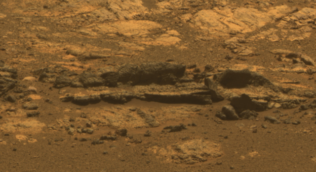
English: Opportunity Eyes Rock Fins on Cape York, Sol 3058
Rock fins up to about 1 foot (30 centimeters) tall dominate this scene from the panoramic camera (Pancam) on NASA's Mars Exploration Rover Opportunity. The component images were taken during the 3,058th Martian day, or sol, of Opportunity's work on Mars (Aug. 23, 2012). The view spans an area of terrain about 30 feet (9 meters) wide. This outcrop is within an area informally named "Matijevic Hill." Orbital investigation of the area has identified a possibility of clay minerals in this area of the Cape York segment of the western rim of Endeavour Crater. The view combines exposures taken through Pancam filters centered on wavelengths of 753 nanometers (near infrared), 535 nanometers (green) and 432 nanometers (violet). It is presented in approximate true color, the camera team's best estimate of what the scene would look like if humans were there and able to see it with their own eyes. Image credit: NASA/JPL-Caltech/Cornell Univ./Arizona State Univ. |
| 날짜 | |
| 출처 | http://www.jpl.nasa.gov/news/news.php?release=2012-306 |
| 저자 | NASA/JPL-Caltech/Cornell Univ./Arizona State Univ. |
| 다른 버전 | http://www.nasa.gov/mission_pages/mer/multimedia/pia16128.html |
라이선스
| 이 파일은 NASA에서 제작하였으므로 퍼블릭 도메인입니다. NASA의 저작권 정책에 따르면 NASA의 자료는 명시하지 않는 이상 저작권의 보호를 받지 않습니다. (Template:PD-USGov, 또는 NASA 저작권 정책 문서, JPL 그림 사용 정책을 참고하세요.) | ||
 |
주의사항:
|
파일 역사
날짜/시간 링크를 클릭하면 해당 시간의 파일을 볼 수 있습니다.
| 날짜/시간 | 섬네일 | 크기 | 사용자 | 설명 | |
|---|---|---|---|---|---|
| 현재 | 2012년 10월 13일 (토) 22:47 | | 640 × 350 (217 KB) | Drbogdan | User created page with UploadWizard |
이 파일을 사용하는 문서
다음 문서 1개가 이 파일을 사용하고 있습니다:
이 파일을 사용하고 있는 모든 위키의 문서 목록
다음 위키에서 이 파일을 사용하고 있습니다:
- en.wikipedia.org에서 이 파일을 사용하고 있는 문서 목록
- es.wikipedia.org에서 이 파일을 사용하고 있는 문서 목록
- pl.wikipedia.org에서 이 파일을 사용하고 있는 문서 목록
- vi.wikipedia.org에서 이 파일을 사용하고 있는 문서 목록
- zh.wikipedia.org에서 이 파일을 사용하고 있는 문서 목록