
파일:Pascatway River New England.jpg
미리 보기 크기: 800 × 569 픽셀 다른 해상도: 320 × 228 픽셀 | 640 × 455 픽셀 | 1,024 × 729 픽셀 | 1,280 × 911 픽셀 | 2,560 × 1,822 픽셀 | 3,440 × 2,448 픽셀
원본 파일 (3,440 × 2,448 픽셀, 파일 크기: 749 KB, MIME 종류: image/jpeg)
파일 설명
| 설명 |
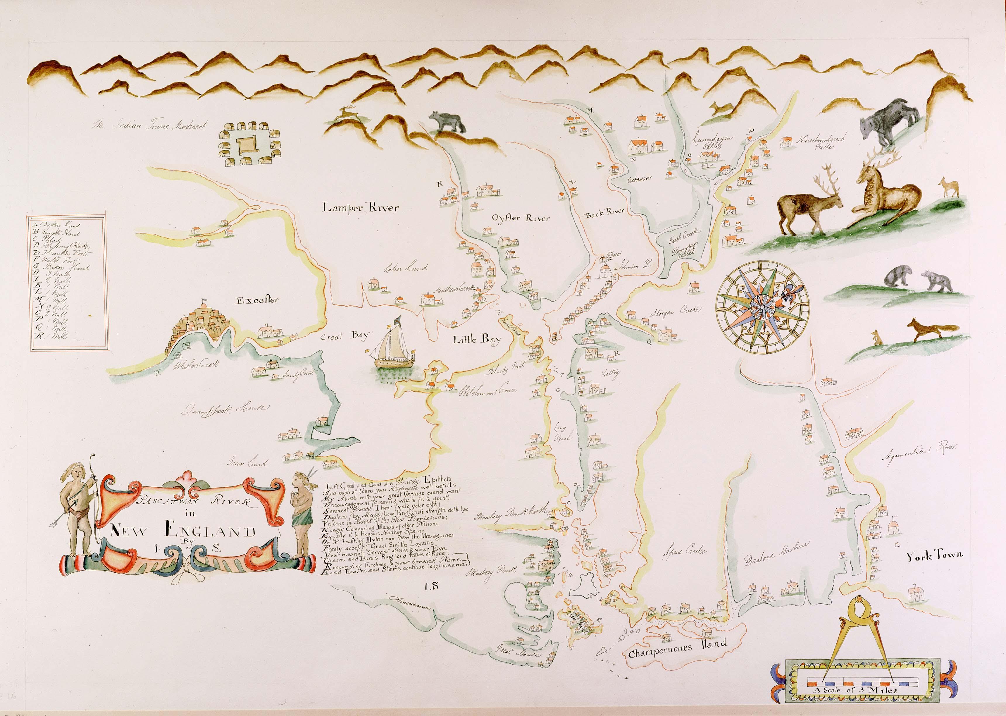
English: Maine historian James Phinney Baxter commissioned the map to be copied from the original in the late 19th century. The original surveyor and creator of the map is unknown, except that the original map carries the initials 'J.S.' from its creator. The map was apparently created during the tenure of King Charles II of England's brother James as the Duke of York, which places its creation sometime around 1670. The map shows the region of the Piscataqua River. Courtesy of the Maine State Archives. Retouched by MarmadukePercy |
| 날짜 | 1670년경 |
| 출처 | http://www.mainememory.net/bin/Detail?ln=6665 |
| 저자 | 미상 |
라이선스
|
이 작품은 미국, 그리고 저작권 보호 기간이 저작자 사후 70년, 또는 그 이하인 모든 국가에서 퍼블릭 도메인입니다.
| |
| 이 저작물은 모든 저작인접권을 포함한 저작권법하의 규제로부터 자유로운 것으로 확인되었습니다. | |
파일 역사
날짜/시간 링크를 클릭하면 해당 시간의 파일을 볼 수 있습니다.
| 날짜/시간 | 섬네일 | 크기 | 사용자 | 설명 | |
|---|---|---|---|---|---|
| 현재 | 2010년 3월 7일 (일) 21:28 | | 3,440 × 2,448 (749 KB) | Justass | resolution |
| 2010년 3월 6일 (토) 07:58 |  | 500 × 334 (91 KB) | MarmadukePercy | {{Information |Description={{en|1=Maine historian James Phinney Baxter commissioned the map to be copied from the original in the late 19th century. The original surveyor and creator of the map is unknown, except that the original map carries the initials |
이 파일을 사용하는 문서
다음 문서 1개가 이 파일을 사용하고 있습니다:
이 파일을 사용하고 있는 모든 위키의 문서 목록
다음 위키에서 이 파일을 사용하고 있습니다:
- arz.wikipedia.org에서 이 파일을 사용하고 있는 문서 목록
- en.wikipedia.org에서 이 파일을 사용하고 있는 문서 목록
- es.wikipedia.org에서 이 파일을 사용하고 있는 문서 목록
- ga.wikipedia.org에서 이 파일을 사용하고 있는 문서 목록
- hu.wikipedia.org에서 이 파일을 사용하고 있는 문서 목록
- la.wikipedia.org에서 이 파일을 사용하고 있는 문서 목록
- sr.wikipedia.org에서 이 파일을 사용하고 있는 문서 목록
- uk.wikipedia.org에서 이 파일을 사용하고 있는 문서 목록