
파일:PIA17085-MarsCuriosityRover-TraverseMap-Sol351-20130801.jpg

원본 파일 (3,300 × 2,550 픽셀, 파일 크기: 2.15 MB, MIME 종류: image/jpeg)
파일 설명
| 설명 |
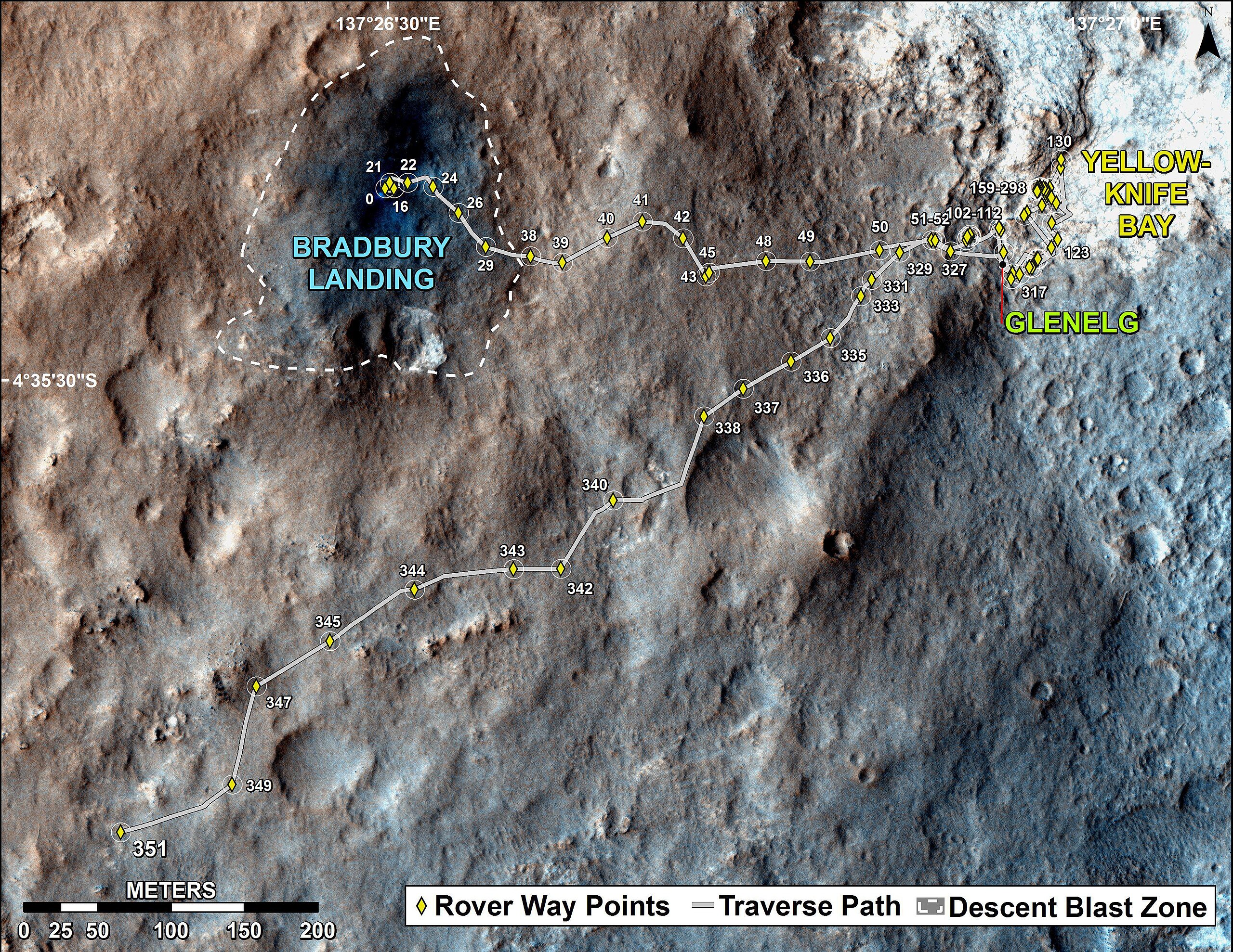
English: PIA17085: Full Curiosity Traverse Passes One-Mile Mark
http://photojournal.jpl.nasa.gov/catalog/PIA17085 NOTE: UPDATED Traverse Maps Are Here => http://mars.jpl.nasa.gov/msl/mission/whereistherovernow/ NOTE: First-Year & First-Mile Traverse Map of the Curiosity rover on Mars (August 1, 2013) (3-D). NASA Description: The total distance driven by NASA's Mars rover Curiosity passed the one-mile mark a few days before the first anniversary of the rover's landing on Mars. This map traces where Curiosity drove between landing at "Bradbury Landing" on Aug. 5, 2012, PDT, (Aug. 6, 2012 (Universal Time and EDT) and the position reached during the mission's 351st Martian day, or sol, (Aug. 1, 2013). The Sol 351 leg added 279 feet (85.1 meters) and brought the odometry since landing to about 1.05 miles (1,686 meters). The mapped area is within Gale Crater and north of the mountain called Mount Sharp in the middle of the crater. After the first use of the drill, the rover's main science destination will be on the lower reaches of Mount Sharp. For broader-context images of the area, see PIA16064 and PIA16058. The base image from the map is from the High Resolution Imaging Science Experiment Camera (HiRISE) in NASA's Mars Reconnaissance Orbiter. |
| 날짜 | |
| 출처 | http://photojournal.jpl.nasa.gov/jpeg/PIA17085.jpg |
| 저자 | NASA/JPL-Caltech/Univ. of Arizona |
라이선스
| 이 파일은 NASA에서 제작하였으므로 퍼블릭 도메인입니다. NASA의 저작권 정책에 따르면 NASA의 자료는 명시하지 않는 이상 저작권의 보호를 받지 않습니다. (Template:PD-USGov, 또는 NASA 저작권 정책 문서, JPL 그림 사용 정책을 참고하세요.) | ||
 |
주의사항:
|
파일 역사
날짜/시간 링크를 클릭하면 해당 시간의 파일을 볼 수 있습니다.
| 날짜/시간 | 섬네일 | 크기 | 사용자 | 설명 | |
|---|---|---|---|---|---|
| 현재 | 2013년 8월 3일 (토) 07:17 | | 3,300 × 2,550 (2.15 MB) | Drbogdan | User created page with UploadWizard |
이 파일을 사용하는 문서
다음 문서 1개가 이 파일을 사용하고 있습니다:
이 파일을 사용하고 있는 모든 위키의 문서 목록
다음 위키에서 이 파일을 사용하고 있습니다:
- ca.wikipedia.org에서 이 파일을 사용하고 있는 문서 목록
- en.wikipedia.org에서 이 파일을 사용하고 있는 문서 목록
- es.wikipedia.org에서 이 파일을 사용하고 있는 문서 목록
- fa.wikipedia.org에서 이 파일을 사용하고 있는 문서 목록
- fr.wikipedia.org에서 이 파일을 사용하고 있는 문서 목록
- it.wikipedia.org에서 이 파일을 사용하고 있는 문서 목록
- ja.wikipedia.org에서 이 파일을 사용하고 있는 문서 목록
- pl.wikipedia.org에서 이 파일을 사용하고 있는 문서 목록
- ru.wikipedia.org에서 이 파일을 사용하고 있는 문서 목록
- tr.wikipedia.org에서 이 파일을 사용하고 있는 문서 목록
- uk.wikipedia.org에서 이 파일을 사용하고 있는 문서 목록
- vi.wikipedia.org에서 이 파일을 사용하고 있는 문서 목록
- zh.wikipedia.org에서 이 파일을 사용하고 있는 문서 목록