
파일:MarsPanoramaa.jpg

원본 파일 (10,000 × 1,248 픽셀, 파일 크기: 11.49 MB, MIME 종류: image/jpeg)
파일 설명
| 설명 |
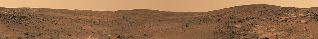
English: Descent from the Summit of 'Husband Hill'
In late November 2005 while descending "Husband Hill", NASA's Mars Exploration Rover Spirit took the most detailed panorama so far of the "Inner Basin", the rover's next target destination. Spirit acquired the 405 individual images that make up this 360-degree view of the surrounding terrain using five different filters on the panoramic camera. The rover took the images on Martian days, or sols, 672 to 677 (23 to 28 Nov. 2005). Français : Vue prise en descendant « Husband Hills », sur Mars. Panorama de 360° obtenu en assemblant 405 photos prises entre le 23 et le 28 novembre 2005 par l'astromobile Spirit de la NASA. Ce panorama est l'image la plus précise de l'« Inner Bassin ». On peut voir en explorant ce panorama en détail les pistes tracées par Spirit lors de son ascension de la colline. |
| 날짜 | Nov. 23-28, 2005 |
| 출처 | NASA Jet Propulsion Laboratory[1] |
| 저자 | NASA |
| 다른 버전 | Restored version of Image:MarsPanorama.jpg with cropping to remove blank patches and minor changes to address stitching flaws. |
| 360° | 360° 파노라마 뷰어로 보기
|
|---|
|

이 이미지는 2011년 1월 12일의 오늘의 이미지로 선정되었습니다. 이미지 설명은 다음과 같습니다. 다른 언어들:
Dansk: Nedkørsel fra toppen af "Husband Hill", en af Columbia-bakkerne i Gusevkrateret i Aeolis quadranglen (180-225° V, 0-30° S) på Mars. Optaget af den ubemandede rumsonde Spirit (en MER) fra 23.-28. november 2005 (Mars soltid, dag 672-677). English: Descent from the Summit of 'Husband Hill', panorama by Spirit Rover taken in 2005. Español: Descenso desde la cima de Husband Hill. Panorámica tomada por el Spirit a finales de noviembre de 2005 en Marte. Italiano: Discesa dalla sommità della collina Husband Hill su Marte ripresa dal rover Spirit durante la sua missione nel 2005. Magyar: Marsi tájkép a Husband Hill-ről nézve Nederlands: Afdaling van de kruin van de Husband Hill, een van de Columbia Hills in de Gusevkrater in het Aeolis-quadrangle (180-225° W, 0-30° Z) van Mars. Panorama gemaakt door het onbemande ruimtevaartuig Spirit (een MER) op 23 tot 28 november 2005 (sol/Martiaanse zonnedag 672 tot 677). Українська: Кругова панорама з вершини Пагорба Хазбенд на Марсі, світлини зроблені марсоходом «Спірит» 23 - 28 листопада 2005 р. 日本語: 火星のハズバンド・ヒル頂上からの下り坂。無人探査機スピリットによる撮影。 |
라이선스
| 이 파일은 NASA에서 제작하였으므로 퍼블릭 도메인입니다. NASA의 저작권 정책에 따르면 NASA의 자료는 명시하지 않는 이상 저작권의 보호를 받지 않습니다. (Template:PD-USGov, 또는 NASA 저작권 정책 문서, JPL 그림 사용 정책을 참고하세요.) | ||
 |
주의사항:
|
파일 역사
날짜/시간 링크를 클릭하면 해당 시간의 파일을 볼 수 있습니다.
| 날짜/시간 | 섬네일 | 크기 | 사용자 | 설명 | |
|---|---|---|---|---|---|
| 현재 | 2008년 3월 1일 (토) 15:40 | 10,000 × 1,248 (11.49 MB) | Durova | {{Information |Description= |Source= |Date= |Author= |Permission= |other_versions= }} | |
| 2008년 3월 1일 (토) 15:27 | 7,000 × 874 (5.9 MB) | Durova | {{Information |Description= |Source=self-made |Date= |Author= Durova |Permission= |other_versions= }} | ||
| 2008년 3월 1일 (토) 15:00 | 5,500 × 686 (2.1 MB) | Durova | {{Information |Description=Descent from the Summit of 'Husband Hill' In late November 2005 while descending "Husband Hill," NASA's Mars Exploration Rover Spirit took the most detailed panorama so far of the "Inner Basin," the rover's next target destinat |
이 파일을 사용하는 문서
다음 문서 2개가 이 파일을 사용하고 있습니다:
이 파일을 사용하고 있는 모든 위키의 문서 목록
다음 위키에서 이 파일을 사용하고 있습니다:
- ar.wikipedia.org에서 이 파일을 사용하고 있는 문서 목록
- ba.wikipedia.org에서 이 파일을 사용하고 있는 문서 목록
- be-tarask.wikipedia.org에서 이 파일을 사용하고 있는 문서 목록
- be.wikipedia.org에서 이 파일을 사용하고 있는 문서 목록
- bg.wikipedia.org에서 이 파일을 사용하고 있는 문서 목록
- bn.wikipedia.org에서 이 파일을 사용하고 있는 문서 목록
- crh.wikipedia.org에서 이 파일을 사용하고 있는 문서 목록
- cv.wikipedia.org에서 이 파일을 사용하고 있는 문서 목록
- da.wikipedia.org에서 이 파일을 사용하고 있는 문서 목록
- en.wikipedia.org에서 이 파일을 사용하고 있는 문서 목록
- Mars rover
- Husband Hill
- User:Kotra
- Portal:Outer space
- Portal:Solar System/Selected picture
- User:Darkieboy236
- Wikipedia:WikiProject Media Restoration/Landmark images
- Wikipedia:Featured pictures thumbs/10
- Wikipedia:Featured picture candidates/March-2008
- Wikipedia:Featured picture candidates/Mars panorama
- Wikipedia:Wikipedia Signpost/2008-03-13/Features and admins
- User talk:Durova/Archive 53
- User:Orion11M87
- Wikipedia:Picture of the day/September 2008
- Template:POTD/2008-09-12
- Wikipedia:Wikipedia Signpost/2008-03-13/SPV
- User talk:Durova/Archive 62
- User:Durova/Featured credits at the Turkish language Wikipedia
- User:Darkieboy236/Sandbox
- User:Durova/Featured picture gallery/2008
- Portal:Outer space/Selected picture
- Portal:Outer space/Selected picture/28
- Wikipedia:Featured pictures/Space/Panorama
- Wikipedia:Wikipedia Signpost/Single/2008-03-13
- en.wikiversity.org에서 이 파일을 사용하고 있는 문서 목록
- es.wikipedia.org에서 이 파일을 사용하고 있는 문서 목록
- fa.wikipedia.org에서 이 파일을 사용하고 있는 문서 목록
- fr.wikipedia.org에서 이 파일을 사용하고 있는 문서 목록
- hu.wikipedia.org에서 이 파일을 사용하고 있는 문서 목록
이 파일의 더 많은 사용 내역을 봅니다.