
파일:Karte saarbruecken in deutschland.png
최대 해상도입니다.
Karte_saarbruecken_in_deutschland.png (188 × 235 픽셀, 파일 크기: 5 KB, MIME 종류: image/png)
파일 설명
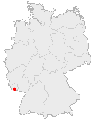
English: Location of Saabruecken in Germany
Lëtzebuergesch: Lag vu Saarbrécken an Däitschland
Zusammenfassung
Lage von Saarbrücken in Deutschland
라이선스
This image was generated with OpenGeoDB. The information there is placed in the public domain, images generated from OpenGeoDB are derivative works without passing the threshold of creativity, they are therefore also public domain.
| 이 저작물은 완전히 공공의 재산으로서의 정보로만 구성되어 있으며, 창작성이 있는 요소가 포함되어 있지 않아 저작권 보호에 부적격하므로 퍼블릭 도메인입니다. |
파일 역사
날짜/시간 링크를 클릭하면 해당 시간의 파일을 볼 수 있습니다.
| 날짜/시간 | 섬네일 | 크기 | 사용자 | 설명 | |
|---|---|---|---|---|---|
| 현재 | 2006년 6월 26일 (월) 01:18 | | 188 × 235 (5 KB) | Yassen~commonswiki | english:Location of Saabrucken in Germany<br> deutsch:Lage von Saarbrücken in Deutschland<br> {{GFDL-OpenGeoDB}} Category:Locator_maps_of_cities_in_Germany |
이 파일을 사용하는 문서
이 파일을 사용하는 문서가 없습니다.
이 파일을 사용하고 있는 모든 위키의 문서 목록
다음 위키에서 이 파일을 사용하고 있습니다:
- af.wikipedia.org에서 이 파일을 사용하고 있는 문서 목록
- azb.wikipedia.org에서 이 파일을 사용하고 있는 문서 목록
- de.wikipedia.org에서 이 파일을 사용하고 있는 문서 목록
- de.wikinews.org에서 이 파일을 사용하고 있는 문서 목록
- fa.wikipedia.org에서 이 파일을 사용하고 있는 문서 목록
- fy.wikipedia.org에서 이 파일을 사용하고 있는 문서 목록
- io.wikipedia.org에서 이 파일을 사용하고 있는 문서 목록
- is.wikipedia.org에서 이 파일을 사용하고 있는 문서 목록
- ja.wikipedia.org에서 이 파일을 사용하고 있는 문서 목록
- la.wiktionary.org에서 이 파일을 사용하고 있는 문서 목록
- lmo.wikipedia.org에서 이 파일을 사용하고 있는 문서 목록
- pl.wikivoyage.org에서 이 파일을 사용하고 있는 문서 목록
- pms.wikipedia.org에서 이 파일을 사용하고 있는 문서 목록
- pnb.wikipedia.org에서 이 파일을 사용하고 있는 문서 목록
- ps.wikipedia.org에서 이 파일을 사용하고 있는 문서 목록
- sq.wikipedia.org에서 이 파일을 사용하고 있는 문서 목록
- uk.wikipedia.org에서 이 파일을 사용하고 있는 문서 목록
- zh-yue.wikipedia.org에서 이 파일을 사용하고 있는 문서 목록