
파일:John-Speed-The-Kingdome-of-China-1626-2544.jpg

미리 보기 크기: 740 × 600 픽셀 다른 해상도: 296 × 240 픽셀 | 593 × 480 픽셀 | 948 × 768 픽셀 | 1,264 × 1,024 픽셀 | 2,024 × 1,640 픽셀
원본 파일 (2,024 × 1,640 픽셀, 파일 크기: 3.98 MB, MIME 종류: image/jpeg)
| 설명 |
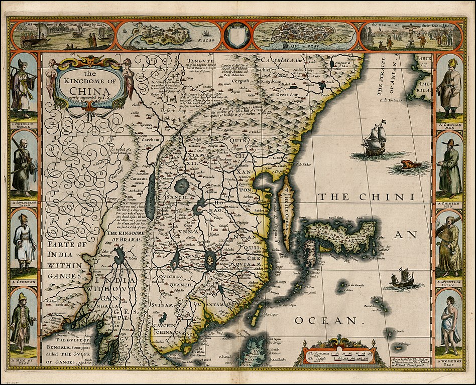
English: "The Kingdome of China", one of the first English-language maps of China. Note generally correct outline of the Ming China, with many provinces labeled (Cantam/Guangdong, Quancii/Guangxi, Chequiam/Zhejiang, Quicheu/Guizhou, Fuquam/en:Huguang/Huguang, Honao/Henan, Xanton/Shandong, Xiamxii and Sancii (Shanxi and Shaanxi?). "Xuntien alias Quinzay" more or less corresponds to Beijing (the name Shuntian Prefecture was indeed in use). However, north of China proper, John Speed had also placed "Cathaya, the Chief Kingdome of Great Cam", with the capital Cambalu (Khanbaliq - i.e., in fact, the same Beijing). This kind of duplication was common on the maps of the period, as geographers had not apparently yet fully identified Marco Polo's Cathay with the China then known to Europeans, and Cambalu with Beijing. |
|||||||||||||||||
| 날짜 | Originally published 1626, reprint 1627 | |||||||||||||||||
| 출처 |
English: An antique map from the Special Collection "China in Maps" of the Hong Kong University of Science and Technology Library, reproduced by the HKUST Library in the book "China in European Maps", Hong Kong, 2003. ISBN 962-86403-9-9.
Русский: Старинная карта из специальной коллекции Библиотеки Гонконгского научно-технического университета. Опубликована этой библиотекой в книге "China in European Maps" (Китай на европейских картах), Гонконг, 2003. ISBN 962-86403-9-9, тиражом 1000 экз. См. также каталог выставки, Special Collection "China in Maps".
Plate 21 |
|||||||||||||||||
| 저자 |
|
|||||||||||||||||
| 저작권 (이 파일을 인용하기) |
Author died more than 70 years ago - public domain | |||||||||||||||||

|
이 작품은 미국, 그리고 저작권 보호 기간이 저작자 사후 70년, 또는 그 이하인 모든 국가에서 퍼블릭 도메인입니다.
| |
| 이 저작물은 모든 저작인접권을 포함한 저작권법하의 규제로부터 자유로운 것으로 확인되었습니다. | |
파일 역사
날짜/시간 링크를 클릭하면 해당 시간의 파일을 볼 수 있습니다.
| 날짜/시간 | 섬네일 | 크기 | 사용자 | 설명 | |
|---|---|---|---|---|---|
| 현재 | 2010년 1월 28일 (목) 21:38 | | 2,024 × 1,640 (3.98 MB) | Vmenkov | better scan of same map, from http://www.raremaps.com/gallery/detail/22839/the_Kingdome_of_China_newly_augmented_by_IS_1626/Speed.html |
| 2009년 3월 22일 (일) 09:35 |  | 2,560 × 1,920 (2.11 MB) | Vmenkov | {{Information |Description={{en|"The Kingdome of China", one of the first English-language maps of China. Note generally correct outline of the Ming China, with many provinces labeled (Cantam/Guangdong, Quancii/Guangxi, Chequiam/Zhejiang, Quicheu/Guizhou, |
이 파일을 사용하는 문서
다음 문서 1개가 이 파일을 사용하고 있습니다:
이 파일을 사용하고 있는 모든 위키의 문서 목록
다음 위키에서 이 파일을 사용하고 있습니다:
- ar.wikipedia.org에서 이 파일을 사용하고 있는 문서 목록
- arz.wikipedia.org에서 이 파일을 사용하고 있는 문서 목록
- ast.wikipedia.org에서 이 파일을 사용하고 있는 문서 목록
- bg.wikipedia.org에서 이 파일을 사용하고 있는 문서 목록
- bn.wikipedia.org에서 이 파일을 사용하고 있는 문서 목록
- ca.wikipedia.org에서 이 파일을 사용하고 있는 문서 목록
- cv.wikipedia.org에서 이 파일을 사용하고 있는 문서 목록
- de.wikivoyage.org에서 이 파일을 사용하고 있는 문서 목록
- el.wikipedia.org에서 이 파일을 사용하고 있는 문서 목록
- en.wikipedia.org에서 이 파일을 사용하고 있는 문서 목록
- en.wikivoyage.org에서 이 파일을 사용하고 있는 문서 목록
- es.wikipedia.org에서 이 파일을 사용하고 있는 문서 목록
- eu.wikipedia.org에서 이 파일을 사용하고 있는 문서 목록
- fa.wikipedia.org에서 이 파일을 사용하고 있는 문서 목록
- fi.wikipedia.org에서 이 파일을 사용하고 있는 문서 목록
- fr.wikipedia.org에서 이 파일을 사용하고 있는 문서 목록
- he.wikipedia.org에서 이 파일을 사용하고 있는 문서 목록
- hu.wikipedia.org에서 이 파일을 사용하고 있는 문서 목록
- hy.wikipedia.org에서 이 파일을 사용하고 있는 문서 목록
- id.wikipedia.org에서 이 파일을 사용하고 있는 문서 목록
- it.wikipedia.org에서 이 파일을 사용하고 있는 문서 목록
- kk.wikipedia.org에서 이 파일을 사용하고 있는 문서 목록
- la.wikipedia.org에서 이 파일을 사용하고 있는 문서 목록
- nl.wikipedia.org에서 이 파일을 사용하고 있는 문서 목록
- nn.wikipedia.org에서 이 파일을 사용하고 있는 문서 목록
- pl.wikipedia.org에서 이 파일을 사용하고 있는 문서 목록
- pnb.wikipedia.org에서 이 파일을 사용하고 있는 문서 목록
- pt.wikipedia.org에서 이 파일을 사용하고 있는 문서 목록
- ru.wikipedia.org에서 이 파일을 사용하고 있는 문서 목록
이 파일의 더 많은 사용 내역을 봅니다.