
파일:Jangmi 2008-09-27 0445Z.jpg

미리 보기 크기: 473 × 599 픽셀 다른 해상도: 189 × 240 픽셀 | 379 × 480 픽셀 | 606 × 768 픽셀 | 808 × 1,024 픽셀 | 1,617 × 2,048 픽셀 | 6,000 × 7,600 픽셀
원본 파일 (6,000 × 7,600 픽셀, 파일 크기: 4.93 MB, MIME 종류: image/jpeg)
파일 설명
| 설명 |
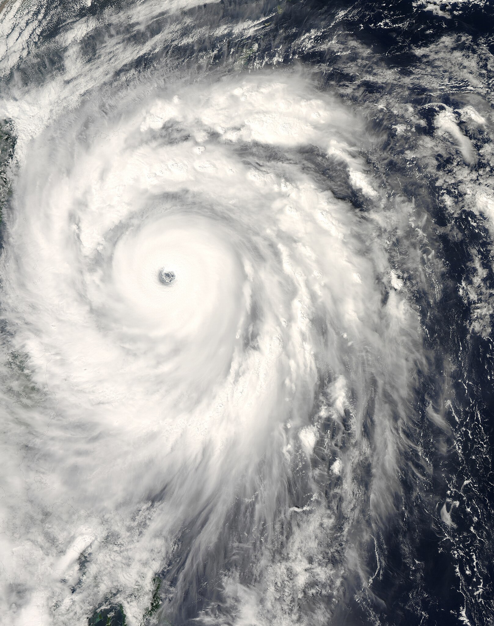
English: The title of “strongest storm of 2008” goes to Typhoon Jangmi, shown in this image from the Moderate Resolution Imaging Spectroradiometer (MODIS) on NASA’s Aqua satellite from September 27, 2008.
Seen from space, even a super typhoon seems more beautiful than dangerous. The 50-kilometer-wide eye of Jangmi is encircled by a smooth disk of clouds. Bands of clouds swirl gracefully into the low-pressure heart of the storm. The smooth cloud band north of the eye is studded with thunderstorms. On the ground, Jangmi was less lovely It was not only the strongest storm in any ocean basin in 2008 but the only storm to reach category 5 strength anywhere in the world that year. |
| 날짜 | |
| 출처 | http://rapidfire.sci.gsfc.nasa.gov/cgi-bin/imagery/single.cgi?image=Jangmi.A2008271.0445.250m.jpg |
| 저자 | MODIS image captured by NASA’s Aqua satellite |
| 카메라 위치 | | 이 지역의 다른 사진을 보기: OpenStreetMap |
|---|
라이선스
| 이 파일은 NASA에서 제작하였으므로 퍼블릭 도메인입니다. NASA의 저작권 정책에 따르면 NASA의 자료는 명시하지 않는 이상 저작권의 보호를 받지 않습니다. (Template:PD-USGov, 또는 NASA 저작권 정책 문서, JPL 그림 사용 정책을 참고하세요.) | ||
 |
주의사항:
|
파일 역사
날짜/시간 링크를 클릭하면 해당 시간의 파일을 볼 수 있습니다.
| 날짜/시간 | 섬네일 | 크기 | 사용자 | 설명 | |
|---|---|---|---|---|---|
| 현재 | 2018년 5월 30일 (수) 22:58 | | 6,000 × 7,600 (4.93 MB) | Nino Marakot | Reverted to version as of 05:09, 9 January 2018 (UTC) |
| 2018년 4월 22일 (일) 08:03 |  | 1,723 × 2,089 (1.06 MB) | Saxitoxin | Less gray | |
| 2018년 4월 22일 (일) 08:02 |  | 1,723 × 2,089 (2.64 MB) | Saxitoxin | More storm centered | |
| 2018년 1월 9일 (화) 14:09 |  | 6,000 × 7,600 (4.93 MB) | Nino Marakot | Reverted to version as of 22:20, 2 November 2008 (UTC) - It's gallery version. Please separate them (it would become 3rd party if stayed) | |
| 2017년 11월 25일 (토) 00:48 |  | 5,985 × 7,980 (9.62 MB) | Meow | Rebuilt. | |
| 2008년 11월 3일 (월) 07:20 |  | 6,000 × 7,600 (4.93 MB) | Cyclonebiskit | {{Information |Description={{en|1={{en|1=Satellite image of Typhoon Jangmi at 0445 UTC Sept. 27, 2008.}}This photo-like image was taken by the Aqua MODIS Satellite as Typhoon Jangmi (or Super Typhoon 19W according to the JTWC) moved closer to the island o |
이 파일을 사용하는 문서
다음 문서 2개가 이 파일을 사용하고 있습니다:
이 파일을 사용하고 있는 모든 위키의 문서 목록
다음 위키에서 이 파일을 사용하고 있습니다:
- de.wikipedia.org에서 이 파일을 사용하고 있는 문서 목록
- en.wikipedia.org에서 이 파일을 사용하고 있는 문서 목록
- ja.wikipedia.org에서 이 파일을 사용하고 있는 문서 목록
- pt.wikipedia.org에서 이 파일을 사용하고 있는 문서 목록
- vi.wikipedia.org에서 이 파일을 사용하고 있는 문서 목록
- zh-yue.wikipedia.org에서 이 파일을 사용하고 있는 문서 목록
- zh.wikipedia.org에서 이 파일을 사용하고 있는 문서 목록