
파일:Hrvatsko Podunavlje.png

미리 보기 크기: 439 × 600 픽셀 다른 해상도: 175 × 240 픽셀 | 351 × 480 픽셀 | 881 × 1,204 픽셀
원본 파일 (881 × 1,204 픽셀, 파일 크기: 79 KB, MIME 종류: image/png)
| 설명 |
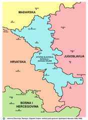
English: Map of the Eastern Slavonia, Baranja and Western Syrmia - Croatian language version. Hrvatski: Mapa Istočne Slavonije, Baranje i Zapadnog Srijema - verzija na hrvatskom jeziku. |
| 날짜 | (UTC) |
| 출처 | |
| 저자 |
|
| 다른 버전 |
|

| 이 그림은 수정된 그림으로, 원래 그림에서 디지털 변환이 이루어진 그림입니다. 수정 사항 : {{{1}}}. 원래의 그림 : Srem baranja.png:
|
나는 아래 작품의 저작권자로서, 이 저작물을 다음과 같은 라이선스로 배포합니다:
| 나는 이 작품의 저작권자로서, 이 작품을 퍼블릭 도메인으로 모두에게 공개합니다. 이 공개 선언은 전 세계적으로 유효합니다. 만약 저작권의 포기가 법률적으로 가능하지 않은 경우, 나는 이 작품을 법적으로 허용되는 한도 내에서 누구나 자유롭게 어떤 목적으로도 제한없이 사용할 수 있도록 허용합니다. |
References
- Sve srpske mape - od šestog veka do Pariza, Specijalno izdanje BLICA, Decembar 1995
- Dr Tomislav Bogavac, Nestajanje Srba, Niš, 1994.
- Miodrag Milošević, Geografija za 8. razred osnovne škole, Beograd, 1994.
- Dragan Rodić, Geografija za I ili III razred srednje škole, Beograd, 1995.
- Istorijski atlas, Geokarta, Beograd, 1999.
- Richard Overy, The Times History of the 20th Century, Times Books, London, 2004.
- The Times History of Europe, Times Books, London, 2002.
- Slavko Vejinović, Srbi u dijaspori u prošlosti i sadašnjosti, Novi Sad, 1999.
- Tim Džuda, Srbi - istorija, mit i razaranje Jugoslavije, Beograd, 2003.
- Džon R. Lempi, Jugoslavija kao istorija, Beograd, 2004.
- Nada Miletić Stanić, Pravoslavne crkve u Baranji, Novi Sad, 1999.
- http://web.ku.edu/~eceurope/hist557/lect20_files/yugoslavprovinces.jpg archive copy at the Wayback Machine
- http://terkepek.adatbank.transindex.ro/kepek/netre/292.gif
- http://www.pointernet.pds.hu/touristinfo/croatia/image/g.jpg archive copy at the Wayback Machine
- http://clip2net.com/clip/m6499/1217833413-krajina_army_territorial_division-jpg-34kb.jpg
- http://profile.ak.fbcdn.net/hprofile-ak-snc4/50514_294052851171_2302284_n.jpg archive copy at the Wayback Machine
- http://www.vecernji.hr/slika-500x329/vijesti/otkrivamo-britanci-trazili-da-baranju-dio-istocne-slavonije-predamo-srbiji-slika-85519[dead link]
- http://www.srpskapolitika.com/krajina/mapa211.jpg archive copy at the Wayback Machine
- http://www.srpska-mreza.com/MAPS/Ethnic-groups/map-UN-1994.jpg
- http://www.srpskapolitika.com/krajina/etnicka_karta.jpg archive copy at the Wayback Machine
- http://www.srpskapolitika.com/krajina/mapa311.jpg archive copy at the Wayback Machine
- http://farm1.static.flickr.com/45/110412384_09ffb827cb.jpg
기존 올리기 기록
This image is a derivative work of the following images:
- File:Srem_baranja.png licensed with PD-self
- 2006-10-01T05:27:44Z Amadalvarez 754x1116 (240718 Bytes) map of the [[Eastern Slavonia, Baranja and Western Srem]] (self made) I'M NOT THE AUTHOR. It's been copied from english wiki, where it has GFDL self Licensing from his author, [[:en:user:PANONIA]] {{PD-self}} [[Category:Yu
Uploaded with derivativeFX
파일 역사
날짜/시간 링크를 클릭하면 해당 시간의 파일을 볼 수 있습니다.
| 날짜/시간 | 섬네일 | 크기 | 사용자 | 설명 | |
|---|---|---|---|---|---|
| 현재 | 2012년 6월 8일 (금) 19:34 | | 881 × 1,204 (79 KB) | PANONIAN | proposing this compromise version: this image shows borders from 1996-1998 (as was suggested as better solution by user:Ex13, but it shows more accurate and more detailed borders as well as more notable towns. if user:Ex13 does not agree with this prop... |
| 2012년 4월 17일 (화) 16:38 |  | 754 × 1,116 (212 KB) | Ex13 | Reverted to version as of 21:14, 15 April 2012 you can upload another file | |
| 2012년 4월 17일 (화) 15:11 |  | 881 × 1,285 (92 KB) | PANONIAN | Reverted to version as of 11:26, 4 August 2011 - this is impoved and corrected version, why you reverted to version with wrong borders? | |
| 2012년 4월 16일 (월) 06:14 |  | 754 × 1,116 (212 KB) | Ex13 | Reverted to version as of 17:42, 20 February 2010 | |
| 2011년 8월 4일 (목) 20:26 |  | 881 × 1,285 (92 KB) | PANONIAN | improved version, same as in in original English language file | |
| 2010년 2월 21일 (일) 02:42 |  | 754 × 1,116 (212 KB) | Ex13 | NEW | |
| 2010년 2월 21일 (일) 02:40 |  | 754 × 1,116 (209 KB) | Ex13 | {{Information |Description=Map of the Eastern Slavonia, Baranja and Western Srem |Source=*File:Srem_baranja.png |Date=2010-02-20 17:38 (UTC) |Author=*File:Srem_baranja.png: It's been copied from english wiki, where it has GFDL self Licensin |
이 파일을 사용하는 문서
다음 문서 1개가 이 파일을 사용하고 있습니다:
이 파일을 사용하고 있는 모든 위키의 문서 목록
다음 위키에서 이 파일을 사용하고 있습니다:
- ar.wikipedia.org에서 이 파일을 사용하고 있는 문서 목록
- azb.wikipedia.org에서 이 파일을 사용하고 있는 문서 목록
- bs.wikipedia.org에서 이 파일을 사용하고 있는 문서 목록
- ca.wikipedia.org에서 이 파일을 사용하고 있는 문서 목록
- ckb.wikipedia.org에서 이 파일을 사용하고 있는 문서 목록
- cs.wikipedia.org에서 이 파일을 사용하고 있는 문서 목록
- de.wikipedia.org에서 이 파일을 사용하고 있는 문서 목록
- el.wikipedia.org에서 이 파일을 사용하고 있는 문서 목록
- en.wikipedia.org에서 이 파일을 사용하고 있는 문서 목록
- fr.wikipedia.org에서 이 파일을 사용하고 있는 문서 목록
- hr.wikipedia.org에서 이 파일을 사용하고 있는 문서 목록
- id.wikipedia.org에서 이 파일을 사용하고 있는 문서 목록
- pl.wikipedia.org에서 이 파일을 사용하고 있는 문서 목록
- ro.wikipedia.org에서 이 파일을 사용하고 있는 문서 목록
- sh.wikipedia.org에서 이 파일을 사용하고 있는 문서 목록
- sk.wikipedia.org에서 이 파일을 사용하고 있는 문서 목록
- sr.wikipedia.org에서 이 파일을 사용하고 있는 문서 목록
- sv.wikipedia.org에서 이 파일을 사용하고 있는 문서 목록
- th.wikipedia.org에서 이 파일을 사용하고 있는 문서 목록
- tr.wikipedia.org에서 이 파일을 사용하고 있는 문서 목록
- uk.wikipedia.org에서 이 파일을 사용하고 있는 문서 목록
- www.wikidata.org에서 이 파일을 사용하고 있는 문서 목록
- zh.wikipedia.org에서 이 파일을 사용하고 있는 문서 목록