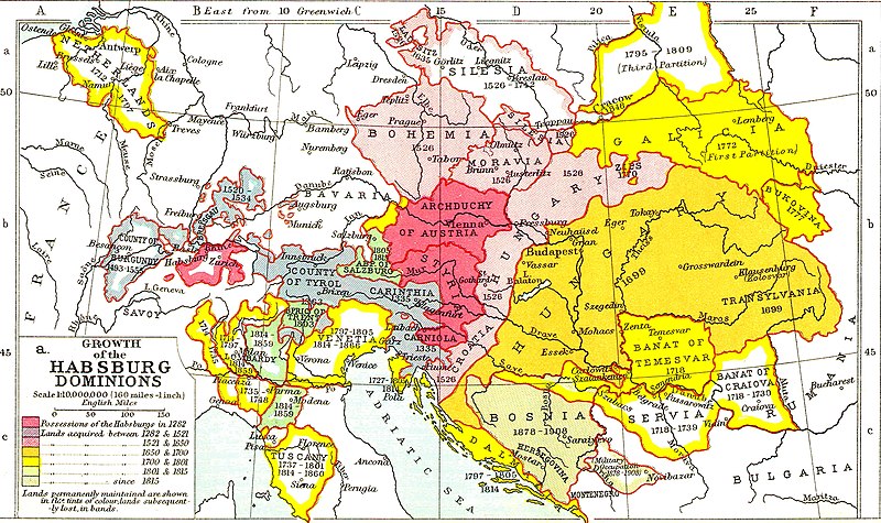
파일:Growth of Habsburg territories.jpg

미리 보기 크기: 800 × 475 픽셀 다른 해상도: 320 × 190 픽셀 | 640 × 380 픽셀 | 1,024 × 608 픽셀 | 1,280 × 760 픽셀 | 2,275 × 1,350 픽셀
원본 파일 (2,275 × 1,350 픽셀, 파일 크기: 1.02 MB, MIME 종류: image/jpeg)
파일 역사
날짜/시간 링크를 클릭하면 해당 시간의 파일을 볼 수 있습니다.
| 날짜/시간 | 섬네일 | 크기 | 사용자 | 설명 | |
|---|---|---|---|---|---|
| 현재 | 2022년 11월 26일 (토) 04:37 |  | 2,275 × 1,350 (1.02 MB) | Gyalu22 | Reverted to version as of 08:54, 16 March 2016 (UTC) |
| 2017년 12월 24일 (일) 04:24 |  | 2,275 × 1,350 (1.03 MB) | MAXHO | Reverted to version as of 2015 according with cited sources | |
| 2016년 3월 16일 (수) 17:54 |  | 2,275 × 1,350 (1.02 MB) | Fakirbakir | back to the original version | |
| 2015년 12월 1일 (화) 02:12 |  | 2,275 × 1,350 (1.03 MB) | Spiridon Ion Cepleanu | Some details according with « Grosser Atlas zur Weltgeschichte » (H.E.Stier, dir.) Westermann 1985, ISBN 3-14-100919-8, « Putzger historischer Weltatlas Cornelsen » 1990, ISBN 3-464-00176-8 & « Történelmi atlasz a középiskolák számára », K... | |
| 2014년 5월 14일 (수) 06:31 |  | 2,275 × 1,350 (1.02 MB) | CSvBibra | contrast | |
| 2009년 2월 16일 (월) 05:27 |  | 2,275 × 1,350 (956 KB) | Bizso | {{Information |Description={{en|1=Growth of Habsburg territories.}} |Source=[http://www.heritage-history.com/maps/philips/phil025a.jpg] |Author=unknown |Date=unnowkn |Permission= |other_versions= }} <!--{{ImageUpload|full}}--> |
이 파일을 사용하는 문서
다음 문서 6개가 이 파일을 사용하고 있습니다:
이 파일을 사용하고 있는 모든 위키의 문서 목록
다음 위키에서 이 파일을 사용하고 있습니다:
- als.wikipedia.org에서 이 파일을 사용하고 있는 문서 목록
- ar.wikipedia.org에서 이 파일을 사용하고 있는 문서 목록
- azb.wikipedia.org에서 이 파일을 사용하고 있는 문서 목록
- ba.wikipedia.org에서 이 파일을 사용하고 있는 문서 목록
- be-tarask.wikipedia.org에서 이 파일을 사용하고 있는 문서 목록
- be.wikipedia.org에서 이 파일을 사용하고 있는 문서 목록
- bg.wikipedia.org에서 이 파일을 사용하고 있는 문서 목록
- bn.wikipedia.org에서 이 파일을 사용하고 있는 문서 목록
- br.wikipedia.org에서 이 파일을 사용하고 있는 문서 목록
- ca.wikipedia.org에서 이 파일을 사용하고 있는 문서 목록
- cs.wikipedia.org에서 이 파일을 사용하고 있는 문서 목록
- da.wikipedia.org에서 이 파일을 사용하고 있는 문서 목록
- el.wikipedia.org에서 이 파일을 사용하고 있는 문서 목록
- en.wikipedia.org에서 이 파일을 사용하고 있는 문서 목록
- es.wikipedia.org에서 이 파일을 사용하고 있는 문서 목록
- et.wikipedia.org에서 이 파일을 사용하고 있는 문서 목록
- fa.wikipedia.org에서 이 파일을 사용하고 있는 문서 목록
- fi.wikipedia.org에서 이 파일을 사용하고 있는 문서 목록
- frr.wikipedia.org에서 이 파일을 사용하고 있는 문서 목록
- fr.wikipedia.org에서 이 파일을 사용하고 있는 문서 목록
이 파일의 더 많은 사용 내역을 봅니다.
