
파일:Erebus 360 L257atc-B652R1.jpg

미리 보기 크기: 800 × 211 픽셀 다른 해상도: 320 × 84 픽셀 | 640 × 168 픽셀 | 1,024 × 270 픽셀 | 1,280 × 337 픽셀 | 2,560 × 674 픽셀 | 22,780 × 5,996 픽셀
원본 파일 (22,780 × 5,996 픽셀, 파일 크기: 74.36 MB, MIME 종류: image/jpeg)
| 주의 | 이 그림은 크기가 상당히 크며, 일부 브라우저의 경우 그림을 실제 크기로 표시할 때 프로그램이 멈출 수 있습니다. 이 경우, '최대 해상도' 링크 위에서 마우스 오른쪽 버튼을 눌러서 컴퓨터 파일로 저장한 다음, 포토샵이나 GIMP 같은 편집기를 이용해서 파일을 열어 주세요. |
|---|
파일 설명
| 설명 |
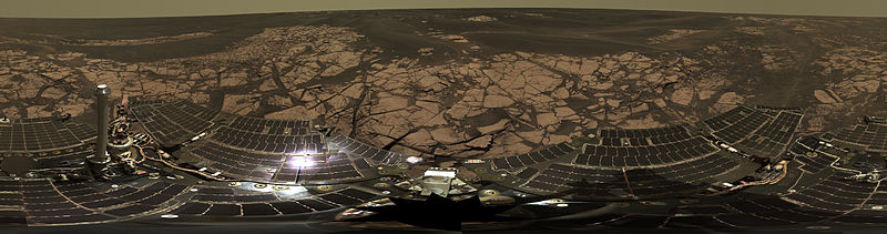
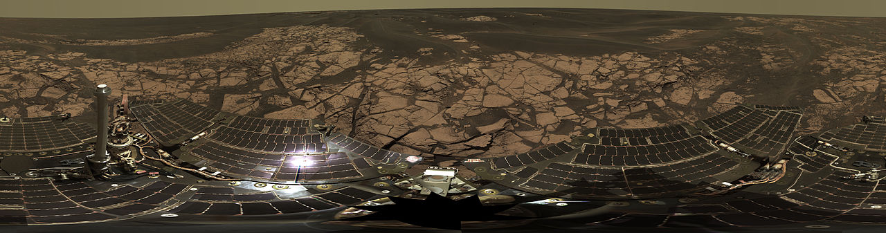
English: This is the Opportunity panoramic camera's "Erebus Rim" panorama, acquired on sols 652 to 663 (Nov. 23 to Dec. 5, 2005 ), as NASA's Mars Exploration Rover Opportunity was exploring sand dunes and outcrop rocks in Meridiani Planum. The panorama originally consisted of 635 separate images in four different Pancam filters, and covers 360 degrees of terrain around the rover and the full rover deck. Since the time that this panorama was acquired, and while engineers have been diagnosing and testing Opportunity's robotic arm, the panorama has been expanded to include more than 1,300 images of this terrain through all of the Pancam multispectral filters. It is the largest panorama acquired by either rover during the mission.
The panorama shown here is an approximate true-color rendering using Pancam's 750 nanometer, 530 nanometer and 430 nanometer filters. It is presented here as a cylindrical projection. Image-to-image seams have been eliminated from the sky portion of the mosaic to better simulate the vista a person standing on Mars would see. This panorama provides the team's highest resolution view yet of the finely-layered outcrop rocks, wind ripples, and small cobbles and grains along the rim of the wide but shallow "Erebus" crater. Once the arm diagnostics and testing are completed, the team hopes to explore other layered outcrop rocks at Erebus and then eventually continue southward toward the large crater known as "Victoria." |
| 날짜 | 2005년 11월 23일 - 2005년 12월 5일 |
| 출처 | http://marsrovers.jpl.nasa.gov/gallery/press/opportunity/20060104a.html / http://photojournal.jpl.nasa.gov/catalog/PIA03270 |
| 저자 | NASA/JPL-Caltech/Cornell |
| 360° | 360° 파노라마 뷰어로 보기
|
|---|
This image or video was catalogued by Jet Propulsion Laboratory of the United States National Aeronautics and Space Administration (NASA) under Photo ID: PIA03270. This tag does not indicate the copyright status of the attached work. A normal copyright tag is still required. See Commons:Licensing. Other languages:
|
라이선스
| 이 파일은 NASA에서 제작하였으므로 퍼블릭 도메인입니다. NASA의 저작권 정책에 따르면 NASA의 자료는 명시하지 않는 이상 저작권의 보호를 받지 않습니다. (Template:PD-USGov, 또는 NASA 저작권 정책 문서, JPL 그림 사용 정책을 참고하세요.) | ||
 |
주의사항:
|
파일 역사
날짜/시간 링크를 클릭하면 해당 시간의 파일을 볼 수 있습니다.
| 날짜/시간 | 섬네일 | 크기 | 사용자 | 설명 | |
|---|---|---|---|---|---|
| 현재 | 2013년 2월 22일 (금) 15:00 | 22,780 × 5,996 (74.36 MB) | Huntster | Original super-resolution version of image. | |
| 2006년 1월 15일 (일) 19:50 | 3,000 × 790 (523 KB) | JamesHoadley | w:Erebus crater. From [http://marsrovers.jpl.nasa.gov/gallery/press/opportunity/20060104a.html]. Original caption: <blockquote>'''On the Rim of 'Erebus'''' This is the Opportunity panoramic camera's "Erebus Rim" panorama, acquired on sols 652 to 66 |
이 파일을 사용하는 문서
다음 문서 1개가 이 파일을 사용하고 있습니다:
이 파일을 사용하고 있는 모든 위키의 문서 목록
다음 위키에서 이 파일을 사용하고 있습니다:
- ast.wikipedia.org에서 이 파일을 사용하고 있는 문서 목록
- bs.wikipedia.org에서 이 파일을 사용하고 있는 문서 목록
- de.wikipedia.org에서 이 파일을 사용하고 있는 문서 목록
- en.wikipedia.org에서 이 파일을 사용하고 있는 문서 목록
- es.wikipedia.org에서 이 파일을 사용하고 있는 문서 목록
- fr.wikipedia.org에서 이 파일을 사용하고 있는 문서 목록
- hi.wikipedia.org에서 이 파일을 사용하고 있는 문서 목록
- it.wikipedia.org에서 이 파일을 사용하고 있는 문서 목록
- ja.wikipedia.org에서 이 파일을 사용하고 있는 문서 목록
- lb.wikipedia.org에서 이 파일을 사용하고 있는 문서 목록
- mn.wikipedia.org에서 이 파일을 사용하고 있는 문서 목록
- pt.wikipedia.org에서 이 파일을 사용하고 있는 문서 목록
- ro.wikipedia.org에서 이 파일을 사용하고 있는 문서 목록
- ru.wikipedia.org에서 이 파일을 사용하고 있는 문서 목록
- uk.wikipedia.org에서 이 파일을 사용하고 있는 문서 목록
- zh.wikipedia.org에서 이 파일을 사용하고 있는 문서 목록