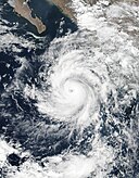
파일:Dora 2017-06-26 2020Z.jpg

미리 보기 크기: 480 × 599 픽셀 다른 해상도: 192 × 240 픽셀 | 384 × 480 픽셀 | 615 × 768 픽셀 | 820 × 1,024 픽셀 | 1,640 × 2,048 픽셀 | 4,009 × 5,005 픽셀
원본 파일 (4,009 × 5,005 픽셀, 파일 크기: 3.22 MB, MIME 종류: image/jpeg)
파일 역사
날짜/시간 링크를 클릭하면 해당 시간의 파일을 볼 수 있습니다.
| 날짜/시간 | 섬네일 | 크기 | 사용자 | 설명 | |
|---|---|---|---|---|---|
| 현재 | 2019년 6월 2일 (일) 15:03 |  | 4,009 × 5,005 (3.22 MB) | Nino Marakot | Cropped 16 % horizontally, 26 % vertically using CropTool with precise mode. |
| 2018년 12월 1일 (토) 03:20 |  | 4,800 × 6,800 (5.32 MB) | FleurDeOdile | remade and centered | |
| 2017년 7월 1일 (토) 20:52 |  | 8,021 × 10,859 (8.21 MB) | ChocolateTrain | As no objection was made on the [https://en.wikipedia.org/wiki/File_talk:Dora_2017-06-26_2020Z.jpg talk page], consensus has now been reached. Any inquiries or concerns must be directed there before any action takes place. | |
| 2017년 6월 29일 (목) 22:43 |  | 5,505 × 7,073 (2.72 MB) | MarioProtIV | Reverted to version as of 06:49, 27 June 2017 (UTC) Still too zoomed in. I am tired of you constantly reverting this. Please take to talk. | |
| 2017년 6월 29일 (목) 13:57 |  | 8,021 × 10,859 (8.21 MB) | ChocolateTrain | Zoomed out further. Effectively the same image as the one that Typhoon2013, MarioProtIV and B dash want. The ugly line has been removed, however, in order to improve the image. | |
| 2017년 6월 29일 (목) 13:28 |  | 5,505 × 7,073 (2.72 MB) | A1Cafel | Reverted because this is not a valid reason, please talk to the editors if you disagree their point of view | |
| 2017년 6월 29일 (목) 11:44 |  | 7,974 × 9,701 (6.68 MB) | ChocolateTrain | Reverted because 'B dash' is blocked indefinitely due to sock puppetry. I must therefore assume that something fishy is going on, and that this account is a sock puppet creating a false sense of support for a viewpoint. Apologies if this is wrong. | |
| 2017년 6월 29일 (목) 11:32 |  | 5,505 × 7,073 (2.72 MB) | A1Cafel | per MarioProtIV and Typhoon2013 | |
| 2017년 6월 29일 (목) 11:07 |  | 7,974 × 9,701 (6.68 MB) | ChocolateTrain | Compromise. I agree it looks better now. All will be happy, finally. | |
| 2017년 6월 29일 (목) 03:43 |  | 5,505 × 7,073 (2.72 MB) | Typhoon2013 | same reason as Mario guy... other words image is TOO close up on the storm itself |
이 파일을 사용하는 문서
다음 문서 1개가 이 파일을 사용하고 있습니다:
이 파일을 사용하고 있는 모든 위키의 문서 목록
다음 위키에서 이 파일을 사용하고 있습니다:
- en.wikipedia.org에서 이 파일을 사용하고 있는 문서 목록
- es.wikipedia.org에서 이 파일을 사용하고 있는 문서 목록
- fr.wikipedia.org에서 이 파일을 사용하고 있는 문서 목록
- pt.wikipedia.org에서 이 파일을 사용하고 있는 문서 목록
- vi.wikipedia.org에서 이 파일을 사용하고 있는 문서 목록
- zh.wikipedia.org에서 이 파일을 사용하고 있는 문서 목록


