
파일:Dead trees at Mammoth Hot Springs.jpg
미리 보기 크기: 800 × 529 픽셀 다른 해상도: 320 × 212 픽셀 | 640 × 423 픽셀 | 1,024 × 677 픽셀 | 1,280 × 846 픽셀 | 2,400 × 1,587 픽셀
원본 파일 (2,400 × 1,587 픽셀, 파일 크기: 2.9 MB, MIME 종류: image/jpeg)
|
파일 설명
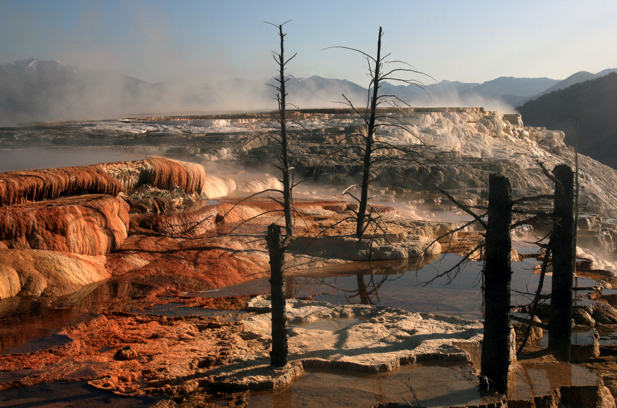
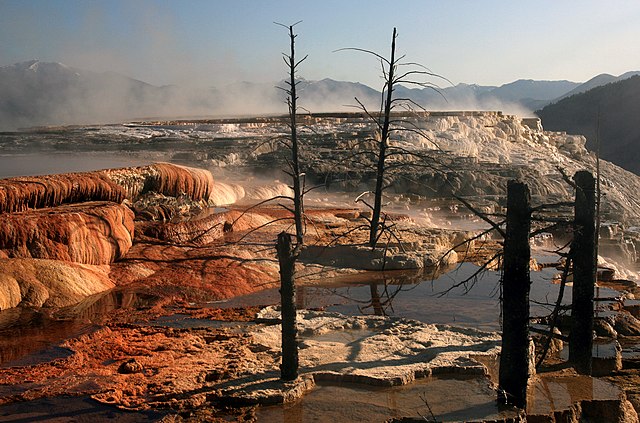
| 설명 | Mammoth Hot Springs terraces. Hot water is the creative force of the terraces.Even though Mammoth Hot Springs lie north of the caldera ring-fracture system, a fault trending north from Norris Geyser Basin, 21 miles (34 km) away, may connect Mammoth Hot Springs to the hot water of that system. A system of small fissures carries water upward to create approximately 50 hot springs in the Mammoth Hot Springs area. Another necessary ingredient for terrace growth is the mineral calcium carbonate. Thick layers of sedimentary limestone, deposited millions of years ago by vast seas, lie beneath the Mammoth area. As ground water seeps slowly downward and laterally, it comes in contact with hot gases charged with carbon dioxide rising from the magma chamber. Some carbon dioxide is readily dissolved in the hot water to form a weak carbonic acid solution. This hot, acidic solution dissolves great quantities of limestone as it works up through the rock layers to the surface hot springs. Once exposed to the open air, some of the carbon dioxide escapes from solution. As this happens, limestone can no longer remain in solution. A solid mineral reforms and is deposited as the travertine that forms the terraces.Dead trees in the terraces of Mammoth Hot Springs, Yellowstone National Park grew during inactivity of the mineral-rich springs, and were killed when calcium carbonate carried by spring water clogged the vascular systems of the trees. |
| 날짜 | |
| 출처 | 자작 |
| 저자 | Brocken Inaglory |
| 카메라 위치 | | 이 지역의 다른 사진을 보기: OpenStreetMap |
|---|
라이선스
나는 아래 작품의 저작권자로서, 이 저작물을 다음과 같은 라이선스로 배포합니다:
이 파일은 크리에이티브 커먼즈 저작자표시-동일조건변경허락 3.0 Unported 라이선스로 배포됩니다.
- 이용자는 다음의 권리를 갖습니다:
- 공유 및 이용 – 저작물의 복제, 배포, 전시, 공연 및 공중송신
- 재창작 – 저작물의 개작, 수정, 2차적저작물 창작
- 다음과 같은 조건을 따라야 합니다:
- 저작자표시 – 적절한 저작자 표시를 제공하고, 라이센스에 대한 링크를 제공하고, 변경사항이 있는지를 표시해야 합니다. 당신은 합리적인 방식으로 표시할 수 있지만, 어떤 방식으로든 사용권 허가자가 당신 또는 당신의 사용을 지지하는 방식으로 표시할 수 없습니다.
- 동일조건변경허락 – 만약 당신이 이 저작물을 리믹스 또는 변형하거나 이 저작물을 기반으로 제작하는 경우, 당신은 당신의 기여물을 원저작물과 동일하거나 호환 가능한 라이선스에 따라 배포하여야 합니다.

|
GNU 자유 문서 사용 허가서 1.2판 또는 자유 소프트웨어 재단에서 발행한 이후 판의 규정에 따라 본 문서를 복제하거나 개작 및 배포할 수 있습니다. 본 문서에는 변경 불가 부분이 없으며, 앞 표지 구절과 뒷 표지 구절도 없습니다. 본 사용 허가서의 전체 내용은 GNU 자유 문서 사용 허가서 부분에 포함되어 있습니다. |
이 라이선스 중에서 목적에 맞는 것을 선택하여 사용할 수 있습니다.
파일 역사
날짜/시간 링크를 클릭하면 해당 시간의 파일을 볼 수 있습니다.
| 날짜/시간 | 섬네일 | 크기 | 사용자 | 설명 | |
|---|---|---|---|---|---|
| 현재 | 2008년 6월 28일 (토) 08:10 | | 2,400 × 1,587 (2.9 MB) | Mbz1 | {{Information |Description={{en|1=m}} |Source=Own work by uploader |Author=Mbz1 |Date= |Permission= |other_versions= }} {{ImageUpload|full}} |
이 파일을 사용하는 문서
다음 문서 1개가 이 파일을 사용하고 있습니다:
이 파일을 사용하고 있는 모든 위키의 문서 목록
다음 위키에서 이 파일을 사용하고 있습니다:
- ca.wikipedia.org에서 이 파일을 사용하고 있는 문서 목록
- da.wikipedia.org에서 이 파일을 사용하고 있는 문서 목록
- de.wikipedia.org에서 이 파일을 사용하고 있는 문서 목록
- en.wikipedia.org에서 이 파일을 사용하고 있는 문서 목록
- Geothermal areas of Yellowstone
- Mammoth Hot Springs
- List of Yellowstone geothermal features
- Wikipedia:Featured pictures/Places/Landscapes
- Wikipedia:WikiProject Wyoming
- Wikipedia:Featured pictures thumbs/22
- Wikipedia:WikiProject Volcanoes/Content
- User talk:Mbz1/a7
- Wikipedia:Featured picture candidates/February-2010
- Wikipedia:Featured picture candidates/Mammoth Hot Springs at Yellowstone National Park
- Wikipedia:Wikipedia Signpost/2010-02-15/Features and admins
- Wikipedia:WikiProject United States/Recognized content
- User talk:Mbz1/Archive 30
- Wikipedia:WikiProject United States/Quality content
- User talk:Mbz1/a77
- Talk:Mammoth Hot Springs
- Wikipedia:WikiProject Wyoming/Featured content
- Wikipedia:Picture of the day/September 2011
- Template:POTD/2011-09-15
- Wikipedia:Main Page history/2011 September 15
- User:Gowtham shiva
- Wikipedia:Wikipedia Signpost/Single/2010-02-15
- Wikipedia:WikiProject United States/Featured pictures
- User:Conceptyphoon/sandbox
- en.wikivoyage.org에서 이 파일을 사용하고 있는 문서 목록
- es.wikipedia.org에서 이 파일을 사용하고 있는 문서 목록
- Geografía de Estados Unidos
- Wikipedia:Recurso del día/julio de 2008
- Wikipedia:Candidatos a recursos destacados/Julio-2008
- Wikipedia:Candidatos a recursos destacados/Dead trees at Mammoth Hot Springs.jpg
- Plantilla:RDD/206
- Wikipedia:Recurso del día/201 - 300
- Wikipedia:Recurso del día/abril de 2009
- Anexo:Patrimonio de la Humanidad en Estados Unidos
- Wikipedia:Recurso del día/julio de 2010
- Wikipedia:Recurso del día/enero de 2012
- Wikipedia:Recurso del día/enero de 2014
- Wikipedia:Recurso del día/julio de 2016
- Wikipedia:Recurso del día/octubre de 2018
- Wikipedia:Recurso del día/febrero de 2021
- Wikipedia:Recurso del día/enero de 2024
- fa.wikipedia.org에서 이 파일을 사용하고 있는 문서 목록
- fr.wikipedia.org에서 이 파일을 사용하고 있는 문서 목록
- hu.wikipedia.org에서 이 파일을 사용하고 있는 문서 목록
이 파일의 더 많은 사용 내역을 봅니다.