
파일:Curiosity Rover Landing Site - Quadmapping Yellowknife.jpg
원본 파일 (1,024 × 768 픽셀, 파일 크기: 173 KB, MIME 종류: image/jpeg)
파일 설명
| 설명 |
English: 08.09.2012
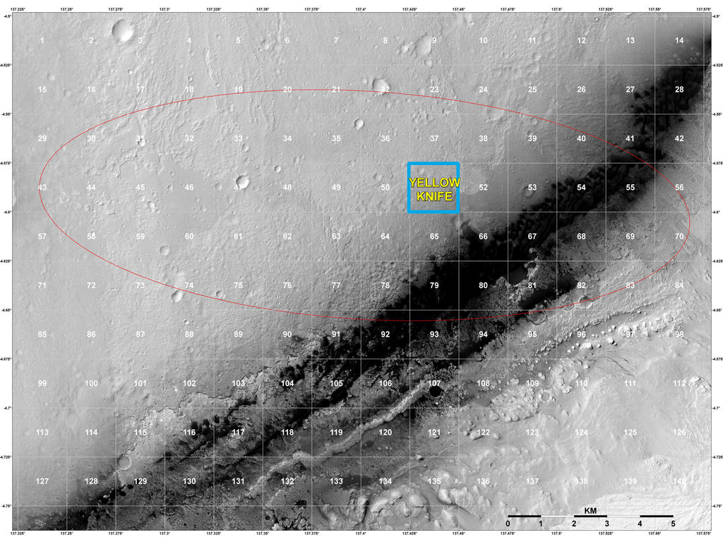
Staking out Curiosity's Landing Site The geological context for the landing site of NASA's Curiosity rover is visible in this image mosaic obtained by the High-Resolution Imaging Science Experiment (HiRISE) camera on NASA's Mars Reconnaissance Orbiter. The area around the landing site has been divided into square areas of interest about .9-mile (1.5-kilometers) wide. The mission has divided the surface into those quadrangles, or quads, so that groups of team members can focus their analysis on a particular part of the surface. Mt. Sharp is to the bottom right, out of the picture. HiRISE is one of six instruments on NASA's Mars Reconnaissance Orbiter. The University of Arizona, Tucson, operates the orbiter's HiRISE camera, which was built by Ball Aerospace & Technologies Corp., Boulder, Colo. NASA's Jet Propulsion Laboratory, a division of the California Institute of Technology in Pasadena, manages the Mars Reconnaissance Orbiter Project for the NASA Science Mission Directorate, Washington. Lockheed Martin Space Systems, Denver, built the spacecraft. Image Credit: NASA/JPL-Caltech/Univ. of Arizona |
| 날짜 | |
| 출처 | http://mars.jpl.nasa.gov/msl/images/pia16031_Sumner_2MSL_Quadmapping_yellowknife-br2.jpg |
| 저자 | NASA/JPL-Caltech/Univ. of Arizona |
라이선스
| 이 파일은 NASA에서 제작하였으므로 퍼블릭 도메인입니다. NASA의 저작권 정책에 따르면 NASA의 자료는 명시하지 않는 이상 저작권의 보호를 받지 않습니다. (Template:PD-USGov, 또는 NASA 저작권 정책 문서, JPL 그림 사용 정책을 참고하세요.) | ||
 |
주의사항:
|
파일 역사
날짜/시간 링크를 클릭하면 해당 시간의 파일을 볼 수 있습니다.
| 날짜/시간 | 섬네일 | 크기 | 사용자 | 설명 | |
|---|---|---|---|---|---|
| 현재 | 2012년 8월 16일 (목) 03:30 | | 1,024 × 768 (173 KB) | Drbogdan |
이 파일을 사용하는 문서
다음 문서 1개가 이 파일을 사용하고 있습니다:
이 파일을 사용하고 있는 모든 위키의 문서 목록
다음 위키에서 이 파일을 사용하고 있습니다:
- bg.wikipedia.org에서 이 파일을 사용하고 있는 문서 목록
- bn.wikipedia.org에서 이 파일을 사용하고 있는 문서 목록
- ca.wikipedia.org에서 이 파일을 사용하고 있는 문서 목록
- en.wikipedia.org에서 이 파일을 사용하고 있는 문서 목록
- es.wikipedia.org에서 이 파일을 사용하고 있는 문서 목록
- fa.wikipedia.org에서 이 파일을 사용하고 있는 문서 목록
- it.wikipedia.org에서 이 파일을 사용하고 있는 문서 목록
- ja.wikipedia.org에서 이 파일을 사용하고 있는 문서 목록
- test.wikipedia.org에서 이 파일을 사용하고 있는 문서 목록
- tr.wikipedia.org에서 이 파일을 사용하고 있는 문서 목록
- uk.wikipedia.org에서 이 파일을 사용하고 있는 문서 목록
- zh.wikipedia.org에서 이 파일을 사용하고 있는 문서 목록