
파일:Crookston Commercial Historic District.jpg

미리 보기 크기: 757 × 599 픽셀 다른 해상도: 303 × 240 픽셀 | 606 × 480 픽셀 | 956 × 757 픽셀
원본 파일 (956 × 757 픽셀, 파일 크기: 84 KB, MIME 종류: image/jpeg)
|
This is an image of a place or building that is listed on the National Register of Historic Places in the United States of America. Its reference number is 84002709. |
| 설명 |
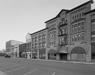
English: Buildings in the Crookston Commercial Historic District in central Crookston, Polk County, Minnesota, United States. The district reflects the city's early period of growth, which was prompted by agriculture and the railroad industry. It remains a large, and mostly intact, concentration of late nineteenth- and early twentieth-century commercial structures and is listed on the National Register of Historic Places. |
|||||
| 날짜 | 날짜를 알 수 없음 | |||||
| 출처 | Library of Congress Prints and Photographs Division, Historic American Buildings Survey: MINN,60-CROK,1-6 | |||||
| 저자 | 미상 | |||||
| 저작권 (이 파일을 인용하기) |
|

| 대상 위치 | | 이 지역의 다른 사진을 보기: OpenStreetMap |
|---|

|
This image is available from the United States Library of Congress's Prints and Photographs division
under the digital ID hhh.mn0444. This tag does not indicate the copyright status of the attached work. A normal copyright tag is still required. See Commons:Licensing.
|
파일 역사
날짜/시간 링크를 클릭하면 해당 시간의 파일을 볼 수 있습니다.
| 날짜/시간 | 섬네일 | 크기 | 사용자 | 설명 | |
|---|---|---|---|---|---|
| 현재 | 2009년 1월 31일 (토) 23:07 | | 956 × 757 (84 KB) | Cropbot | upload cropped version, operated by User:Finavon. Summary: border cropped |
| 2009년 1월 29일 (목) 23:35 |  | 1,024 × 818 (96 KB) | Nyttend | {{Information |Description=Photograph from the {{w|Historic American Buildings Survey}} of buildings in the {{w|Crookston Commercial Historic District}}, an area listed on the {{w|National Register of Historic Places}}. The district is located in central |
이 파일을 사용하는 문서
다음 문서 1개가 이 파일을 사용하고 있습니다:
이 파일을 사용하고 있는 모든 위키의 문서 목록
다음 위키에서 이 파일을 사용하고 있습니다:
- ar.wikipedia.org에서 이 파일을 사용하고 있는 문서 목록
- arz.wikipedia.org에서 이 파일을 사용하고 있는 문서 목록
- azb.wikipedia.org에서 이 파일을 사용하고 있는 문서 목록
- be.wikipedia.org에서 이 파일을 사용하고 있는 문서 목록
- ca.wikipedia.org에서 이 파일을 사용하고 있는 문서 목록
- ceb.wikipedia.org에서 이 파일을 사용하고 있는 문서 목록
- ce.wikipedia.org에서 이 파일을 사용하고 있는 문서 목록
- dag.wikipedia.org에서 이 파일을 사용하고 있는 문서 목록
- de.wikipedia.org에서 이 파일을 사용하고 있는 문서 목록
- en.wikipedia.org에서 이 파일을 사용하고 있는 문서 목록
- en.wikivoyage.org에서 이 파일을 사용하고 있는 문서 목록
- es.wikipedia.org에서 이 파일을 사용하고 있는 문서 목록
- eu.wikipedia.org에서 이 파일을 사용하고 있는 문서 목록
- fa.wikipedia.org에서 이 파일을 사용하고 있는 문서 목록
- fr.wikipedia.org에서 이 파일을 사용하고 있는 문서 목록
- ht.wikipedia.org에서 이 파일을 사용하고 있는 문서 목록
- hu.wikipedia.org에서 이 파일을 사용하고 있는 문서 목록
- ia.wikipedia.org에서 이 파일을 사용하고 있는 문서 목록
- ky.wikipedia.org에서 이 파일을 사용하고 있는 문서 목록
- lld.wikipedia.org에서 이 파일을 사용하고 있는 문서 목록
- pt.wikipedia.org에서 이 파일을 사용하고 있는 문서 목록
- ru.wikipedia.org에서 이 파일을 사용하고 있는 문서 목록
- sh.wikipedia.org에서 이 파일을 사용하고 있는 문서 목록
- sr.wikipedia.org에서 이 파일을 사용하고 있는 문서 목록
- tr.wikipedia.org에서 이 파일을 사용하고 있는 문서 목록
- tt.wikipedia.org에서 이 파일을 사용하고 있는 문서 목록
- uk.wikipedia.org에서 이 파일을 사용하고 있는 문서 목록
- ur.wikipedia.org에서 이 파일을 사용하고 있는 문서 목록
- uz.wikipedia.org에서 이 파일을 사용하고 있는 문서 목록
- vi.wikipedia.org에서 이 파일을 사용하고 있는 문서 목록
- www.wikidata.org에서 이 파일을 사용하고 있는 문서 목록
- zh-min-nan.wikipedia.org에서 이 파일을 사용하고 있는 문서 목록