
파일:Cape Helles landing map.jpg
미리 보기 크기: 789 × 599 픽셀 다른 해상도: 316 × 240 픽셀 | 632 × 480 픽셀 | 845 × 642 픽셀
원본 파일 (845 × 642 픽셀, 파일 크기: 72 KB, MIME 종류: image/jpeg)
파일 설명
| 설명 |
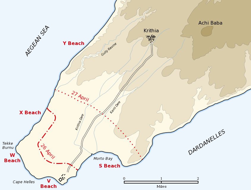
English: Map of the landing of the British 29th Division at Cape Helles on April 25, 1915 during the Battle of Gallipoli. The front line established by the night of April 26 is shown by the red dash-dot line. The front line reached by the night of April 27 is shown by the red dotted line. This became the "jumping off" line for the First Battle of Krithia. |
||
| 날짜 | |||
| 출처 | Self created from map [1] in Hamilton, Ian (1920년) Gallipoli Diary, Volume I, Category:New York: George H Doran Company | ||
| 저자 | Gsl | ||
| 저작권 (이 파일을 인용하기) |
|
||
| 다른 버전 |
|


![[1]](http://gutenberg.readingroo.ms/1/9/3/1/19317/19317-h/images/img-map.jpg)
기존 올리기 기록
The original description page was Helles landing map.jpg here. All following user names refer to en.wikipedia.
- 2004-05-16 06:37 Gsl 845×642× (64213 bytes)
파일 역사
날짜/시간 링크를 클릭하면 해당 시간의 파일을 볼 수 있습니다.
| 날짜/시간 | 섬네일 | 크기 | 사용자 | 설명 | |
|---|---|---|---|---|---|
| 현재 | 2012년 6월 22일 (금) 03:20 | | 845 × 642 (72 KB) | Hohum | Sea to blue |
| 2005년 5월 7일 (토) 00:04 |  | 845 × 642 (63 KB) | Anathema | Map of the landing of the British 29th Division at Cape Helles, Gallipoli, on April 25, 1915. The front line established by the night of April 26 is shown by the red dash-dot line. The front line reached by the night of April 27 is shown by the red |
이 파일을 사용하는 문서
다음 문서 1개가 이 파일을 사용하고 있습니다:
이 파일을 사용하고 있는 모든 위키의 문서 목록
다음 위키에서 이 파일을 사용하고 있습니다:
- ar.wikipedia.org에서 이 파일을 사용하고 있는 문서 목록
- ast.wikipedia.org에서 이 파일을 사용하고 있는 문서 목록
- bg.wikipedia.org에서 이 파일을 사용하고 있는 문서 목록
- ca.wikipedia.org에서 이 파일을 사용하고 있는 문서 목록
- cs.wikipedia.org에서 이 파일을 사용하고 있는 문서 목록
- da.wikipedia.org에서 이 파일을 사용하고 있는 문서 목록
- de.wikipedia.org에서 이 파일을 사용하고 있는 문서 목록
- en.wikipedia.org에서 이 파일을 사용하고 있는 문서 목록
- fr.wikipedia.org에서 이 파일을 사용하고 있는 문서 목록
- fy.wikipedia.org에서 이 파일을 사용하고 있는 문서 목록
- he.wikipedia.org에서 이 파일을 사용하고 있는 문서 목록
- id.wikipedia.org에서 이 파일을 사용하고 있는 문서 목록
- io.wikipedia.org에서 이 파일을 사용하고 있는 문서 목록
- it.wikipedia.org에서 이 파일을 사용하고 있는 문서 목록
- no.wikipedia.org에서 이 파일을 사용하고 있는 문서 목록
- pl.wikipedia.org에서 이 파일을 사용하고 있는 문서 목록
- pt.wikipedia.org에서 이 파일을 사용하고 있는 문서 목록
- ro.wikipedia.org에서 이 파일을 사용하고 있는 문서 목록
- ru.wikipedia.org에서 이 파일을 사용하고 있는 문서 목록
- sr.wikipedia.org에서 이 파일을 사용하고 있는 문서 목록
- uk.wikipedia.org에서 이 파일을 사용하고 있는 문서 목록