
파일:Bopha Dec 3 2012 0435Z (alternate).jpg

미리 보기 크기: 600 × 600 픽셀 다른 해상도: 240 × 240 픽셀 | 480 × 480 픽셀 | 768 × 768 픽셀 | 1,024 × 1,024 픽셀 | 2,048 × 2,048 픽셀 | 5,000 × 5,000 픽셀
원본 파일 (5,000 × 5,000 픽셀, 파일 크기: 13.9 MB, MIME 종류: image/jpeg)
.jpg?uselang=ko)
파일 설명
| 설명 |
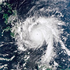
English: Bopha continued moving toward the Philippines on December 3, 2012. The Visible Infrared Imaging Radiometer Suite (VIIRS) on the Suomi NPP satellite acquired this natural-color image the same day. Over the previous day, Bopha moved west of Palau, and by December 3, storm clouds were skirting the island of Mindanao.
The same day that VIIRS acquired this image, the U.S. Navy’s Joint Typhoon Warning Center (JTWC) reported that Bopha packed sustained winds of 140 knots (260 kilometers per hour) and gusts up to 170 knots (315 kilometers per hour). The storm was located about 630 nautical miles (1,170 kilometers) southeast of the Philippine capital of Manila, and was moving toward the west-northwest, JTWC reported. |
|||
| 날짜 | ||||
| 출처 | http://earthobservatory.nasa.gov/NaturalHazards/view.php?id=79872 | |||
| 저자 | NASA Earth Observatory image by Jesse Allen, using VIIRS Day-Night Band data from the Suomi National Polar-orbiting Partnership. Caption by Michon Scott. | |||
| 저작권 (이 파일을 인용하기) |
|
라이선스
| 이 파일은 NASA에서 제작하였으므로 퍼블릭 도메인입니다. NASA의 저작권 정책에 따르면 NASA의 자료는 명시하지 않는 이상 저작권의 보호를 받지 않습니다. (Template:PD-USGov, 또는 NASA 저작권 정책 문서, JPL 그림 사용 정책을 참고하세요.) | ||
 |
주의사항:
|
파일 역사
날짜/시간 링크를 클릭하면 해당 시간의 파일을 볼 수 있습니다.
| 날짜/시간 | 섬네일 | 크기 | 사용자 | 설명 | |
|---|---|---|---|---|---|
| 현재 | 2012년 12월 4일 (화) 07:23 | | 5,000 × 5,000 (13.9 MB) | Supportstorm | {{Information |Description ={{en|1=Bopha continued moving toward the Philippines on December 3, 2012. The Visible Infrared Imaging Radiometer Suite (VIIRS) on the Suomi NPP satellite acquired this natural-color image the same day. Over the previous ... |
이 파일을 사용하는 문서
이 파일을 사용하는 문서가 없습니다.
이 파일을 사용하고 있는 모든 위키의 문서 목록
다음 위키에서 이 파일을 사용하고 있습니다:
- de.wikipedia.org에서 이 파일을 사용하고 있는 문서 목록
- en.wikipedia.org에서 이 파일을 사용하고 있는 문서 목록
- fr.wikipedia.org에서 이 파일을 사용하고 있는 문서 목록
- id.wikipedia.org에서 이 파일을 사용하고 있는 문서 목록
- pl.wikipedia.org에서 이 파일을 사용하고 있는 문서 목록
- th.wikipedia.org에서 이 파일을 사용하고 있는 문서 목록
- zh.wikipedia.org에서 이 파일을 사용하고 있는 문서 목록
.jpg)