
파일:Bahn-Streckenkarte Deutschland-06-2010.png

원본 파일 (1,122 × 1,515 픽셀, 파일 크기: 680 KB, MIME 종류: image/png)
| 설명 |
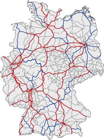
Deutsch: Eisenbahnnetz in Deutschland. Rot: ICE-Strecken; blau: IC/EC-Strecken; grau: sonstiger Personenverkehr
English: Railway network of Germany. Red: lines with InterCityExpress traffic; blue: lines with InterCity/EuroCity traffic; grey: lines with other passenger traffic
Français : Réseau ferré allemand. Rouge : lignes InterCityExpress (ICE); bleu : lignes InterCity/EuroCity; gris : autres lignes de transport de passagers
Magyar: Németország vasúthálózata ;vörös :Vasútvonal InterCityExpress közlekedéssel ;kék :Vasútvonal InterCity/EuroCity közlekedéssel ;szürke :Vasútvonal egyéb személyvonat forgalommal |
|||
| 날짜 | (UTC) | |||
| 출처 | ||||
| 저자 |
|
|||
| 다른 버전 |
|


| 이 그림은 수정된 그림으로, 원래 그림에서 디지털 변환이 이루어진 그림입니다. 수정 사항 : Aktualisiert. 원래의 그림 : Bahn-Streckenkarte Deutschland.png:
|
This image was generated with OpenGeoDB. The information there is placed in the public domain, images generated from OpenGeoDB are derivative works without passing the threshold of creativity, they are therefore also public domain.
| 이 저작물은 완전히 공공의 재산으로서의 정보로만 구성되어 있으며, 창작성이 있는 요소가 포함되어 있지 않아 저작권 보호에 부적격하므로 퍼블릭 도메인입니다. In case this file would pass the threshold of originality, the copyright holder allows the use of this file with the following conditions:
{{PD-ineligible}}
|
기존 올리기 기록
This image was a derivative work of the following image:
- File:Bahn-Streckenkarte_Deutschland.png licensed with GFDL-OpenGeoDB, PD-ineligible
- 2006-05-02T01:06:28Z Qualle 1122x1515 (215324 Bytes) {{Information| |Description={{de|Eisenbahnnetz in Deutschland ;rot :ICE-Strecken ;blau :IC/EC-Strecken ;grau :sonstiger Personenverkehr}}{{en|Railway network of Germany ;red :lines with InterCityExpress traffic ;blue :lines w
Uploaded with derivativeFX
In order to reestablish file version continuity for those who still link to the older file File:Bahn-Streckenkarte_Deutschland.png, on February 16, 2011, the current version of this file has been uploaded as current version of File:Bahn-Streckenkarte_Deutschland.png to its location in Wikimedia Commons. --Qniemiec (talk) 02:16, 16 February 2011 (UTC)
파일 역사
날짜/시간 링크를 클릭하면 해당 시간의 파일을 볼 수 있습니다.
| 날짜/시간 | 섬네일 | 크기 | 사용자 | 설명 | |
|---|---|---|---|---|---|
| 현재 | 2010년 6월 6일 (일) 20:58 | | 1,122 × 1,515 (680 KB) | YouthOfSword | {{Information |Description={{de|Eisenbahnnetz in Deutschland ;rot :ICE-Strecken ;blau :IC/EC-Strecken ;grau :sonstiger Personenverkehr }} <br /> {{en|Railway network of Germany ;red :lines with InterCityExpress traffic ;blue :lines with InterCity/EuroCity |
이 파일을 사용하는 문서
이 파일을 사용하는 문서가 없습니다.
이 파일을 사용하고 있는 모든 위키의 문서 목록
다음 위키에서 이 파일을 사용하고 있습니다:
- de.wikipedia.org에서 이 파일을 사용하고 있는 문서 목록
- en.wikipedia.org에서 이 파일을 사용하고 있는 문서 목록
- fr.wiktionary.org에서 이 파일을 사용하고 있는 문서 목록
- ja.wikipedia.org에서 이 파일을 사용하고 있는 문서 목록
- zh.wikipedia.org에서 이 파일을 사용하고 있는 문서 목록