
파일:AgrihanNASA.jpg

미리 보기 크기: 800 × 535 픽셀 다른 해상도: 320 × 214 픽셀 | 640 × 428 픽셀 | 1,000 × 669 픽셀
원본 파일 (1,000 × 669 픽셀, 파일 크기: 144 KB, MIME 종류: image/jpeg)
파일 설명
| 설명 |
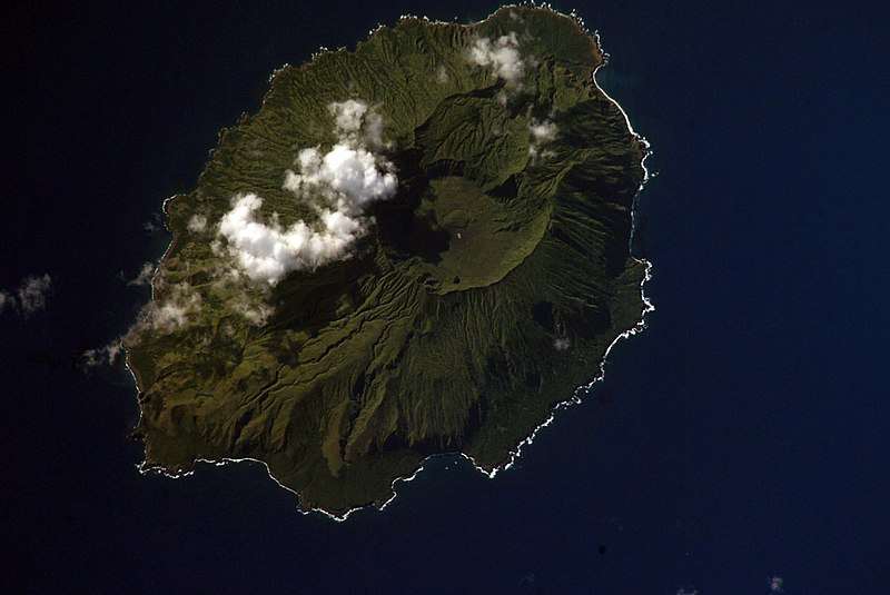
English: NASA Space Shuttle image of Agrihan island in the Northern Mariana Islands.
|
||||||||||||||||||||||||||||||||||||||||||||||||||
| 장소 | Northern Mariana Islands | ||||||||||||||||||||||||||||||||||||||||||||||||||
| 날짜 | |||||||||||||||||||||||||||||||||||||||||||||||||||
| 출처 |
|
||||||||||||||||||||||||||||||||||||||||||||||||||
| 저자 | NASA | ||||||||||||||||||||||||||||||||||||||||||||||||||
| 대상 위치 | | 이 지역의 다른 사진을 보기: OpenStreetMap |
|---|
This image or video was catalogued by one of the centers of the United States National Aeronautics and Space Administration (NASA) under Photo ID: ISS006-E-42419. This tag does not indicate the copyright status of the attached work. A normal copyright tag is still required. See Commons:Licensing. Other languages:
|
라이선스
This file is in the public domain in the United States because it was created by the Image Science & Analysis Laboratory, of the NASA Johnson Space Center. NASA copyright policy states that "NASA material is not protected by copyright unless noted". (NASA media use guidelines or Conditions of Use of Astronaut Photographs).
Photo source: ISS006-E-42419.
|
파일 역사
날짜/시간 링크를 클릭하면 해당 시간의 파일을 볼 수 있습니다.
| 날짜/시간 | 섬네일 | 크기 | 사용자 | 설명 | |
|---|---|---|---|---|---|
| 현재 | 2007년 4월 22일 (일) 13:54 | | 1,000 × 669 (144 KB) | Seattle Skier | == Summary == {{Information |Description= NASA Space Shuttle image of Agrihan island in the Northern Mariana Islands. |Source= http://www.oceandots.com/pacific/mariana/agrihan.htm |Date= 01 April 2003 |Location = [[Northern Mariana Islands |
이 파일을 사용하는 문서
다음 문서 1개가 이 파일을 사용하고 있습니다:
이 파일을 사용하고 있는 모든 위키의 문서 목록
다음 위키에서 이 파일을 사용하고 있습니다:
- arz.wikipedia.org에서 이 파일을 사용하고 있는 문서 목록
- ast.wikipedia.org에서 이 파일을 사용하고 있는 문서 목록
- ceb.wikipedia.org에서 이 파일을 사용하고 있는 문서 목록
- de.wikipedia.org에서 이 파일을 사용하고 있는 문서 목록
- en.wikipedia.org에서 이 파일을 사용하고 있는 문서 목록
- en.wiktionary.org에서 이 파일을 사용하고 있는 문서 목록
- eo.wikipedia.org에서 이 파일을 사용하고 있는 문서 목록
- es.wikipedia.org에서 이 파일을 사용하고 있는 문서 목록
- et.wikipedia.org에서 이 파일을 사용하고 있는 문서 목록
- fa.wikipedia.org에서 이 파일을 사용하고 있는 문서 목록
- fi.wikipedia.org에서 이 파일을 사용하고 있는 문서 목록
- fr.wikipedia.org에서 이 파일을 사용하고 있는 문서 목록
- fr.wikiquote.org에서 이 파일을 사용하고 있는 문서 목록
- gcr.wikipedia.org에서 이 파일을 사용하고 있는 문서 목록
- gl.wikipedia.org에서 이 파일을 사용하고 있는 문서 목록
- it.wikipedia.org에서 이 파일을 사용하고 있는 문서 목록
- ja.wikipedia.org에서 이 파일을 사용하고 있는 문서 목록
- ka.wikipedia.org에서 이 파일을 사용하고 있는 문서 목록
- lld.wikipedia.org에서 이 파일을 사용하고 있는 문서 목록
- ms.wikipedia.org에서 이 파일을 사용하고 있는 문서 목록
- mzn.wikipedia.org에서 이 파일을 사용하고 있는 문서 목록
- nl.wikipedia.org에서 이 파일을 사용하고 있는 문서 목록
- pl.wikipedia.org에서 이 파일을 사용하고 있는 문서 목록
- pt.wiktionary.org에서 이 파일을 사용하고 있는 문서 목록
- ru.wikipedia.org에서 이 파일을 사용하고 있는 문서 목록
- ru.wiktionary.org에서 이 파일을 사용하고 있는 문서 목록
- sk.wikipedia.org에서 이 파일을 사용하고 있는 문서 목록
- sv.wikipedia.org에서 이 파일을 사용하고 있는 문서 목록
- ur.wikipedia.org에서 이 파일을 사용하고 있는 문서 목록
- vi.wikipedia.org에서 이 파일을 사용하고 있는 문서 목록
- www.wikidata.org에서 이 파일을 사용하고 있는 문서 목록
- zh.wikipedia.org에서 이 파일을 사용하고 있는 문서 목록