
파일:Administrative division of denmark in medieval times.jpg
미리 보기 크기: 800 × 583 픽셀 다른 해상도: 320 × 233 픽셀 | 640 × 466 픽셀 | 1,024 × 746 픽셀 | 1,280 × 932 픽셀 | 2,560 × 1,865 픽셀 | 5,952 × 4,336 픽셀
원본 파일 (5,952 × 4,336 픽셀, 파일 크기: 15.8 MB, MIME 종류: image/jpeg)
파일 설명
| 묘사 |
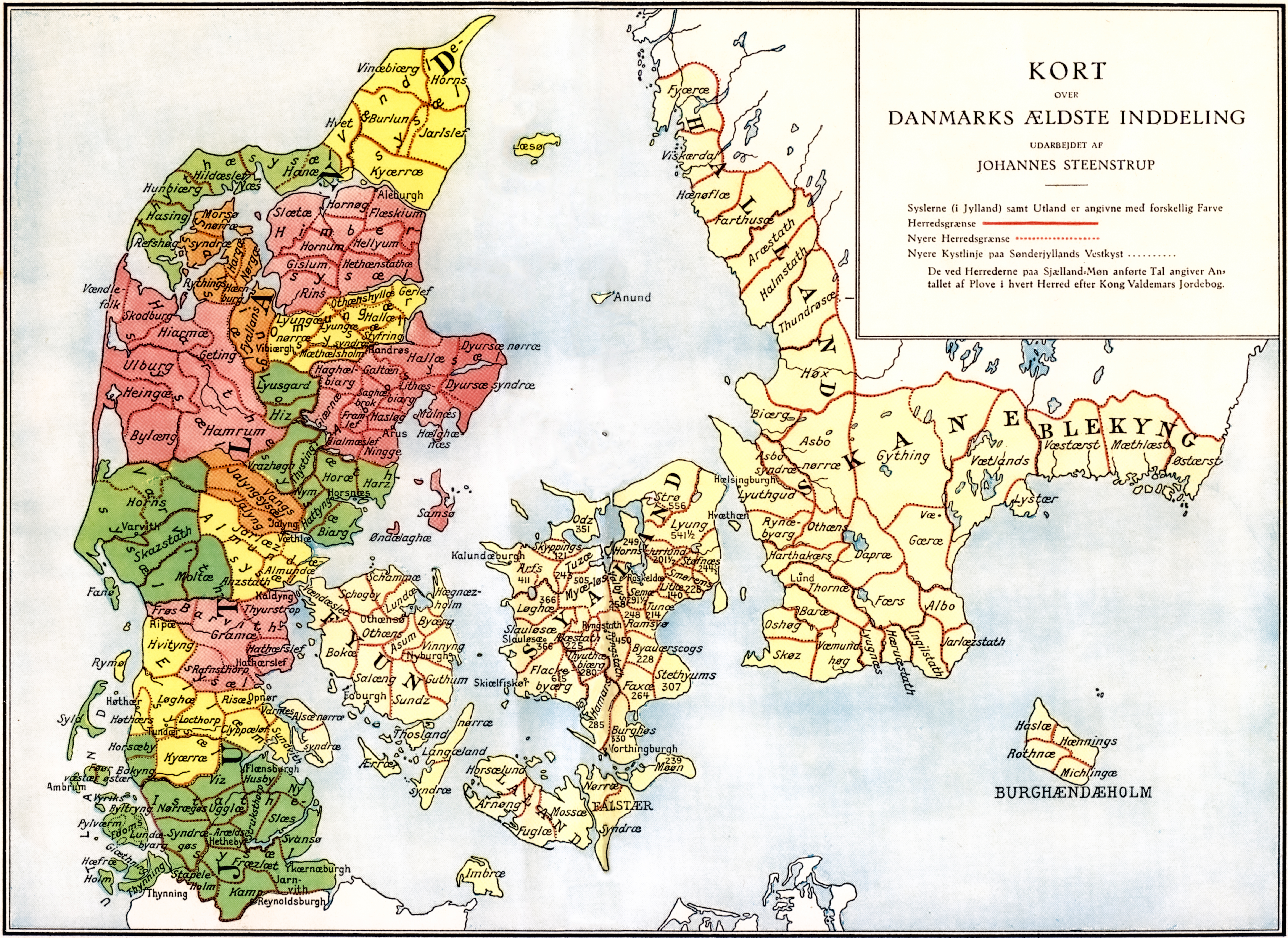
Administrative division of Denmark in Medieval times. |
||||||||||||||||||||
| 지도 범례 | The different colors indicate the division in sysler in Jutland while the red lines indicate borders between herreder (hundreds). Dotted red lines indicate newer borders. Note:The purely ecclesiastic sysler on Zealand are not included on this map. | ||||||||||||||||||||
| 출처 | The map was made by professor Johannes Steenstrup (died 1935) for use in Danmarks Riges Historie (1900, after page 625) and is in Public Domain since Steenstrup died more than 70 years ago. | ||||||||||||||||||||
| 창작자 |
|
||||||||||||||||||||
| 저작권 (이 파일을 인용하기) |
|
||||||||||||||||||||
| 지리 참고 | 부적절한 경우에 숨기려면 warp_status = skip로 설정하세요. | ||||||||||||||||||||
| 다른 버전 | |||||||||||||||||||||


.jpg)

.jpg)
.jpg)
.jpg)
.jpg)
.jpg)
.jpg)
.jpg)
.jpg)
.jpg)
.jpg)
.jpg)
.jpg)


.jpg)
파일 역사
날짜/시간 링크를 클릭하면 해당 시간의 파일을 볼 수 있습니다.
| 날짜/시간 | 섬네일 | 크기 | 사용자 | 설명 | |
|---|---|---|---|---|---|
| 현재 | 2019년 6월 13일 (목) 01:30 | | 5,952 × 4,336 (15.8 MB) | Aeroid | removed vertical lines, straight, slight color change |
| 2005년 6월 19일 (일) 14:36 |  | 5,952 × 4,336 (16.87 MB) | Heelgrasper | Administrative division of Denmark in Medieval times. The different colors indicate the division in "sysler" in Jutland while the red lines indicate borders between "herreder" (counties). Dotted red lines indicate never borders. The map is made by profes |
이 파일을 사용하는 문서
다음 문서 1개가 이 파일을 사용하고 있습니다:
이 파일을 사용하고 있는 모든 위키의 문서 목록
다음 위키에서 이 파일을 사용하고 있습니다:
- cs.wikipedia.org에서 이 파일을 사용하고 있는 문서 목록
- da.wikipedia.org에서 이 파일을 사용하고 있는 문서 목록
- de.wikipedia.org에서 이 파일을 사용하고 있는 문서 목록
- en.wikipedia.org에서 이 파일을 사용하고 있는 문서 목록
- eo.wikipedia.org에서 이 파일을 사용하고 있는 문서 목록
- es.wikipedia.org에서 이 파일을 사용하고 있는 문서 목록
- et.wikipedia.org에서 이 파일을 사용하고 있는 문서 목록
- fi.wikipedia.org에서 이 파일을 사용하고 있는 문서 목록
- frr.wikipedia.org에서 이 파일을 사용하고 있는 문서 목록
- fr.wikipedia.org에서 이 파일을 사용하고 있는 문서 목록
- he.wikipedia.org에서 이 파일을 사용하고 있는 문서 목록
- hu.wikipedia.org에서 이 파일을 사용하고 있는 문서 목록
- id.wikipedia.org에서 이 파일을 사용하고 있는 문서 목록
- it.wikipedia.org에서 이 파일을 사용하고 있는 문서 목록
- la.wikipedia.org에서 이 파일을 사용하고 있는 문서 목록
- nds.wikipedia.org에서 이 파일을 사용하고 있는 문서 목록
- nl.wikipedia.org에서 이 파일을 사용하고 있는 문서 목록
- no.wikipedia.org에서 이 파일을 사용하고 있는 문서 목록
이 파일의 더 많은 사용 내역을 봅니다.