
파일:Location greek ancient.png
최대 해상도입니다.
Location_greek_ancient.png (248 × 113 픽셀, 파일 크기: 4 KB, MIME 종류: image/png)
파일 설명
| 설명 |
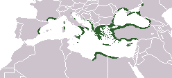
English: Locator map depicting the ancient Greek world, c. 550 BC |
|||
| 날짜 | ||||
| 출처 | Self-created, after http://www.wwnorton.com/nrl/english/nawol/maps/MAP7GRCO.JPG | |||
| 저자 | User:ChrisO | |||
| 저작권 (이 파일을 인용하기) |
|
|||
| 다른 버전 |
|


파일 역사
날짜/시간 링크를 클릭하면 해당 시간의 파일을 볼 수 있습니다.
| 날짜/시간 | 섬네일 | 크기 | 사용자 | 설명 | |
|---|---|---|---|---|---|
| 현재 | 2021년 9월 28일 (화) 01:20 | | 248 × 113 (4 KB) | Deji Olajide1999 | Added the missing regions of Orestis, Elimiotis, Eordaia and Tymphaea + cleared up the Greek colonies in Thrace. |
| 2018년 1월 23일 (화) 18:22 |  | 248 × 113 (4 KB) | Maphobbyist | Added Colchis. | |
| 2014년 6월 27일 (금) 01:15 |  | 248 × 113 (6 KB) | SilentResident | Added missing kingdom of Epirus | |
| 2012년 12월 29일 (토) 19:55 |  | 248 × 113 (5 KB) | Gepgepgep | Aggiunta l'area di colonizzazione greca dell'Adriatico, che mancava completamente | |
| 2011년 9월 6일 (화) 02:22 |  | 248 × 113 (5 KB) | Spesh531 | Showing borders that are recognized. Still showing unrecognized countries for a reference of where Ancient Greek was. It was also about the shape of the lands, as Greek Islands where either not shown correctly or not there at all | |
| 2011년 9월 5일 (월) 22:00 |  | 248 × 113 (4 KB) | Maphobbyist | Pfrevious user Saguamundi is right. International borders, and NOT disputed borders must be shown. Nor is this about the present but about historical Greek settlements. There is no place for current politics for a historical map. | |
| 2011년 9월 5일 (월) 07:28 |  | 248 × 113 (5 KB) | Spesh531 | Reverted to version as of 01:56, 11 May 2011 The border were fine, your showing territories where some are unrecognizable | |
| 2011년 9월 5일 (월) 07:21 |  | 248 × 113 (5 KB) | Spesh531 | Reverted to version as of 01:56, 11 May 2011 The border were fine, your showing territories where some are unrecognizable | |
| 2011년 9월 5일 (월) 06:26 |  | 248 × 113 (4 KB) | Saguamundi | Same map but with internationally recognized borders. | |
| 2011년 5월 11일 (수) 10:56 |  | 248 × 113 (5 KB) | Spesh531 | update more to source, the current Greece was not under territory. |
이 파일을 사용하는 문서
이 파일을 사용하는 문서가 없습니다.
이 파일을 사용하고 있는 모든 위키의 문서 목록
다음 위키에서 이 파일을 사용하고 있습니다:
- en.wikipedia.org에서 이 파일을 사용하고 있는 문서 목록
- pl.wikibooks.org에서 이 파일을 사용하고 있는 문서 목록