파일:Cyclone Catarina from the ISS on March 26 2004.JPG
문서 내용이 다른 언어로는 지원되지 않습니다.
위키백과, 우리 모두의 백과사전.

원본 파일(3,032 × 2,004 픽셀, 파일 크기: 1.01 MB, MIME 종류: image/jpeg)

모습 of the year
모습 of the year
모습 of the day
모습 of the day
Former Featured picture

위키미디어 공용위키백과

이 파일은 2006년 올해의 이미지에서 후보로 선정되었습니다.
이 파일은 2007년 2월 15일오늘의 이미지로 선정되었습니다.
이 파일은 위키미디어 공용 (알찬 그림)에서 알찬 이미지였으며 최우수 이미지 중 하나로 여겨졌습니다.
 이 파일은 8:5, 16:10, 또는 16:9 화면 비율로, 와이드스크린 컴퓨터 바탕화면으로 쓰기에 적합한 이미지입니다. (관련 화랑)

위키백과
 이 파일은 아랍어 위키백과 (صور مختارة)에서 알찬 이미지였으며 최우수 이미지 중 하나로 여겨집니다.
 이 파일은 영어 위키백과 (Featured pictures)에서 알찬 이미지였으며 최우수 이미지 중 하나로 여겨졌습니다.
 이 파일은 스페인어 위키백과 (Recursos destacados)에서 알찬 이미지였으며 최우수 이미지 중 하나로 여겨집니다.
 이 파일은 말레이어 위키백과 (Gambar pilihan)에서 알찬 이미지였으며 최우수 이미지 중 하나로 여겨집니다.
 이 파일은 터키어 위키백과 (Seçkin resimler)에서 알찬 이미지였으며 최우수 이미지 중 하나로 여겨집니다.

비슷한 품질의 이미지를 알맞은 라이선스로 배포할 수 있다면, 파일을 올린 후에 저작권 태그를 붙여서 후보로 등록 해주세요.

설명
العربية: قبل سنة 2004م، سُجِّل ظُهور عاصفتين إستوائيتين فقط في حوض المُحيط الأطلسي الجنوبي، دون أن تظهر أيَّة أعاصير. على أنَّ إحدى العواصف الصغيرة التي ظهرت مُقابل شواطئ البرازيل الجنوبيَّة تطوَّرت حتَّى أصبحت لها خصائص العاصفة الاستوائيَّة واستمرَّت تتضخَّم مع توجُهها نحو الغرب. وسُرعان ما أصبح لِهذه العاصفة عينٌ مركزيَّة ووصلت قُوَّتها إلى قُوَّة الإعصار بِحسب الظاهر يوم الجُمُعة 26 آذار (مارس)، قبل أن يضرب اليابسة في أواخر يوم السبت 27 آذار (مارس) 2004م.
أُعلم طاقم محطَّة الفضاء الدوليَّة بِهذه العاصفة فالتقطوا لها صُورًا مُمتازة ما أن ضربت اليابسة في ولاية سانتا كاترينا بِجنوب البرازيل (بناءً على هذا أُطلق على العاصفة تسمية إعصار كاترينا). لاحظ كيف أنَّ حركة الأعاصير في النصف الجنوبي من الكُرة الأرضيَّة هي باتجاه عقارب. يُمكن رُؤية الساحل البرازيلي أسفل الغُيُوم في الزاوية العُليا اليُسرى من الصُورة.
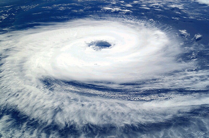
English: Before the year 2004, only two tropical cyclones had ever been noted in the South Atlantic Basin, and no hurricane. However, a circulation center well off the coast of southern Brazil developed tropical cyclone characteristics and continued to intensify as it moved westward. The system developed an eye and apparently reached hurricane strength on Friday, March 26, before eventually making landfall late on Saturday, March 27, 2004.
The crew of the International Space Station was notified of the cyclone and acquired excellent photographs of the storm just as it made landfall on the southern Brazilian state of Santa Catarina (the storm has been unofficially dubbed “Cyclone Catarina”). Note the clockwise circulation of Southern Hemisphere cyclones, the well-defined banding features, and the eyewall of at least a Category 1 system. The coastline is visible under the clouds in the upper left corner of the image.
Français : Avant 2004, aucun cyclone n'a jamais été observé dans l'Atlantique sud. Cependant, au cours du mois de mars 2004, un système dépressionnaire situé loin au large du Brésil a développé toutes les caractéristiques d'un ouragan tout en se déplaçant vers l'ouest. Le 26 mars, l'ouragan forme un œil bien défini ce qui correspond au niveau Cyclone. Le 27 mars 2007 au soir, il atteint les côtes brésiliennes.
L'équipe de la station spatiale internationale, informée du développement de ce cyclone inhabituel, a pu prendre de belles photos du cyclone juste au moment ou il a touché terre dans l'état brésilien de Santa Catarina (D’où son nom officieux de Cyclone Catarina. Le cyclone présente sur cette photo un œil bien défini, et tourne dans le sens des aiguilles d'une montre. La côte est visible en haut à gauche de l'image.
날짜 촬영 날짜: 2004년 3월 26일
출처

NASA

이 그림은 수정된 그림으로, 원래 그림에서 디지털 변환이 이루어진 그림입니다. 수정 사항 : Increased contrast; decreased brightness; adjusted color balance in favor of blues and whites; removed large black splotches in several locations. 수정판 제작자 Tomf688.

저자 Astronaut photograph ISS008-E-19646 was taken March 7, 2004, with a Kodak DCS760 digital camera equipped with an 50-mm lens, and is provided by the Earth Observations Laboratory, Johnson Space Center.
저작권
(이 파일을 인용하기)
Public domain 이 파일은 NASA에서 제작하였으므로 퍼블릭 도메인입니다. NASA의 저작권 정책에 따르면 NASA의 자료는 명시하지 않는 이상 저작권의 보호를 받지 않습니다. (Template:PD-USGov, 또는 NASA 저작권 정책 문서, JPL 그림 사용 정책을 참고하세요.)
주의사항:
This file was reviewed on 2011년 5월 24일 by the administrator or trusted user Jappalang (talk), who confirmed the Public Domain status on that date.
다른 버전

이 파일은 다음으로 파생됨:

This image or video was catalogued by one of the centers of the United States National Aeronautics and Space Administration (NASA) under Photo ID: ISS008-E-19646.

This tag does not indicate the copyright status of the attached work. A normal copyright tag is still required. See Commons:Licensing.

설명

이 파일이 나타내는 바에 대한 한 줄 설명을 추가합니다

이 파일에 묘사된 항목

다음을 묘사함

파일 역사

날짜/시간 링크를 클릭하면 해당 시간의 파일을 볼 수 있습니다.

날짜/시간섬네일크기사용자설명
현재2006년 9월 11일 (월) 09:562006년 9월 11일 (월) 09:56 판의 섬네일3,032 × 2,004 (1.01 MB)Tomhigher res
2005년 9월 8일 (목) 22:102005년 9월 8일 (목) 22:10 판의 섬네일1,000 × 662 (321 KB)Tom
2005년 8월 24일 (수) 15:272005년 8월 24일 (수) 15:27 판의 섬네일1,000 × 662 (321 KB)Tom{{PD-USGov-NASA}} http://eol.jsc.nasa.gov/sseop/images/EO/highres/ISS008/ISS008-E-19646.JPG Only two tropical cyclones had ever been noted in the South Atlantic Basin, and no hurricanes. However, a circulation center well off the coast of southern Brazi

이 파일을 사용하고 있는 모든 위키의 문서 목록

다음 위키에서 이 파일을 사용하고 있습니다:

이 파일의 더 많은 사용 내역을 봅니다.

메타데이터