
파일:TorresStraitIslandsMap.png

미리 보기 크기: 604 × 599 픽셀 다른 해상도: 242 × 240 픽셀 | 484 × 480 픽셀 | 929 × 922 픽셀
원본 파일 (929 × 922 픽셀, 파일 크기: 28 KB, MIME 종류: image/png)
파일 설명

|
이 그림 파일은 벡터 SVG 형식으로 다시 만들어야 합니다. SVG의 장점에 대해서는 여기(영어)를 참고해 주십시오. 만약 이 그림의 SVG 버전이 이미 존재한다면 이 틀을 {{vector version available|새 파일 이름.svg}}으로 대체해 주십시오.
|
| 설명 |
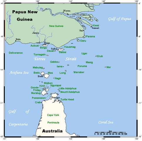
A map of the Torres Strait Islands. I have endeavoured to use native names wherever I could find them. If you can suggest ways in which this map could be made more up to date, don't hesitate to leave me a message to that effect. This map's source is here, with the uploader's modifications, and the GMT homepage says that the tools are released under the GNU General Public License. |
| 날짜 | 2006년 4월 18일 (원본 올리기 일시) |
| 출처 | en.wikipedia에서 공용으로 옮겨왔습니다. |
| 저자 | 영어 위키백과의 Kelisi |
| 다른 버전 | Image:TorresStraitIslandsMap (zh).png |
.png)
라이선스
Kelisi from en.wikipedia.org은(는) 아래 작품의 저작권자로서, 해당 저작물을 다음과 같은 라이선스로 배포합니다:
| 이 파일은 크리에이티브 커먼즈 저작자표시-동일조건변경허락 3.0 Unported 라이선스로 배포됩니다. 면책 조항이 적용됩니다. | ||
| 저작자표시: Kelisi from en.wikipedia.org | ||
| ||
| 이 라이선스 틀은 GFDL 라이선스 변경의 일부로 이 파일에 추가되었습니다. |

|
GNU 자유 문서 사용 허가서 1.2판 또는 자유 소프트웨어 재단에서 발행한 이후 판의 규정에 따라 본 문서를 복제하거나 개작 및 배포할 수 있습니다. 본 문서에는 변경 불가 부분이 없으며, 앞 표지 구절과 뒷 표지 구절도 없습니다. 본 사용 허가서의 전체 내용은 GNU 자유 문서 사용 허가서 부분에 포함되어 있습니다. 면책 조항이 적용됩니다. |
기존 올리기 기록
The original description page was here. All following user names refer to en.wikipedia.
- 2006-04-19 00:55 Kelisi 929×922×8 (28510 bytes)
- 2006-04-18 03:38 Kelisi 929×922×8 (28133 bytes) A map of the Torres Strait Islands. I have endeavoured to use native names wherever I could find them. If you can suggest ways in which this map could be made more up to date, don't hesitate to leave me a message to that effect. This map's source is [htt
파일 역사
날짜/시간 링크를 클릭하면 해당 시간의 파일을 볼 수 있습니다.
| 날짜/시간 | 섬네일 | 크기 | 사용자 | 설명 | |
|---|---|---|---|---|---|
| 현재 | 2022년 1월 13일 (목) 15:42 | | 929 × 922 (28 KB) | Kelisi | Reverted to version as of 00:09, 1 May 2007 (UTC) Hardly; those two colours are closer to each other. |
| 2021년 10월 7일 (목) 02:59 |  | 929 × 922 (31 KB) | Claude Zygiel | Better contrast | |
| 2007년 5월 1일 (화) 09:09 |  | 929 × 922 (28 KB) | Stanmar | {{Information |Description=A map of the Torres Strait Islands. I have endeavoured to use native names wherever I could find them. If you can suggest ways in which this map could be made more up to date, don't hesitate to leave me a message to that effect. |
이 파일을 사용하는 문서
이 파일을 사용하고 있는 모든 위키의 문서 목록
다음 위키에서 이 파일을 사용하고 있습니다:
- af.wikipedia.org에서 이 파일을 사용하고 있는 문서 목록
- als.wikipedia.org에서 이 파일을 사용하고 있는 문서 목록
- ar.wikipedia.org에서 이 파일을 사용하고 있는 문서 목록
- azb.wikipedia.org에서 이 파일을 사용하고 있는 문서 목록
- ba.wikipedia.org에서 이 파일을 사용하고 있는 문서 목록
- bg.wikipedia.org에서 이 파일을 사용하고 있는 문서 목록
- bn.wikipedia.org에서 이 파일을 사용하고 있는 문서 목록
- br.wikipedia.org에서 이 파일을 사용하고 있는 문서 목록
- ca.wikipedia.org에서 이 파일을 사용하고 있는 문서 목록
- ceb.wikipedia.org에서 이 파일을 사용하고 있는 문서 목록
- cs.wikipedia.org에서 이 파일을 사용하고 있는 문서 목록
- cy.wikipedia.org에서 이 파일을 사용하고 있는 문서 목록
- da.wikipedia.org에서 이 파일을 사용하고 있는 문서 목록
- de.wikipedia.org에서 이 파일을 사용하고 있는 문서 목록
- Torres-Straße
- Prince-of-Wales-Insel (Queensland)
- Torres-Straits-Expedition
- Bellevue-Inseln
- Mabuiag
- Talbot-Inseln
- Boigu
- Flagge der Torres-Strait-Insulaner
- Manar-Inseln
- Thursday Island
- Horn Island (Torres Strait)
- Saibai
- Thursday-Inseln
- The Three Sisters (Torres Strait)
- Dauan
- Bet Island
- Poll Island
- Sue Island
- Murray-Inseln
- Murray Island
- Badu Island
- Moa Island
- Coconut Island (Australien)
- Yam Island
- Hammond Island
- Goods Island
- Friday Island (Torres Strait)
이 파일의 더 많은 사용 내역을 봅니다.